
Seller's Agent in 2026
Heather Dever
Showcase Realty, Inc.
(203) 528-8993
1 in this area
73 Total Sales
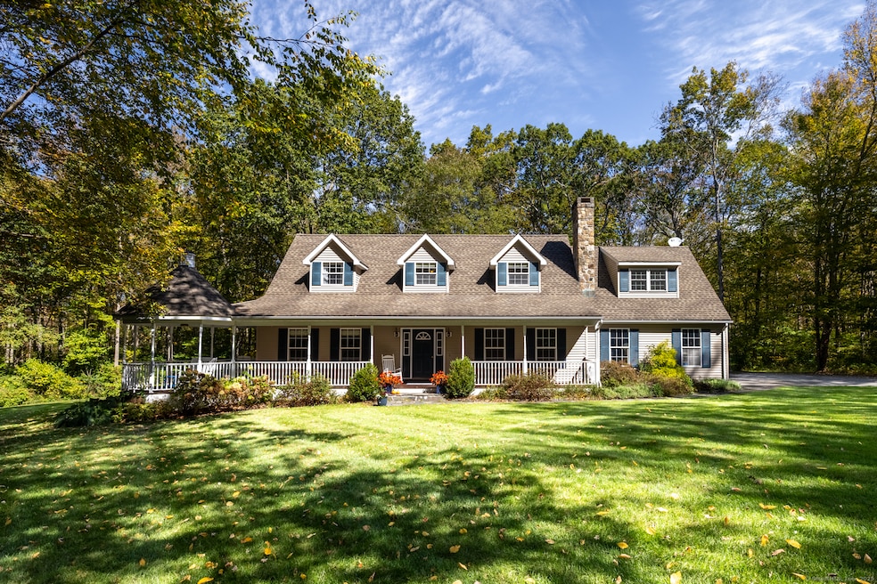
Nestled on a serene 3.85-acre lot in a desirable Bethlehem subdivision, this beautifully maintained Cape offers the perfect blend of privacy, comfort, and modern updates. The home welcomes you with a mahogany front porch, complete with rocking chairs, a porch swing, and a gazebo - an inviting space to unwind and enjoy the peaceful surroundings. Everything freshly painted inside, the hardwood floors refinished and new carpet in the bedrooms. The spacious living room features a cozy stone fireplace with an insert and blower, providing warmth and charm on cool evenings. A versatile floor plan offers two bedrooms and a full bath on the main level, ideal for guests or a home office. Upstairs, the primary suite is a true retreat with custom built-ins, a double vanity, and a walk-in shower. A second en suite bedroom and a bright upper foyer with hardwood flooring offer additional space for a reading nook or office area. The dining room opens through French doors to a bluestone patio, perfect for entertaining or relaxing amid the natural beauty of the backyard. Additional highlights include programmable mini splits (2024), a new boiler (2019), and a new roof (2013). The 2 car garage features a polished concrete floor in a matte finish. Outdoors, enjoy a garden shed, lush landscaping, and ample space for gardening or play. This interior lot ensures privacy while still being part of a lovely community. Shared driveway, No drive-bys, confirmed appointments only.
Last Agent to Sell the Property
Showcase Realty, Inc. Brokerage Phone: (203) 528-8993 License #RES.0798408 Listed on: 10/08/2025
| Date | Type | Sale Price | Title Company |
|---|---|---|---|
| Warranty Deed | $640,000 | -- | |
| Quit Claim Deed | -- | None Available | |
| Quit Claim Deed | -- | None Available | |
| Quit Claim Deed | -- | None Available | |
| Deed | $410,000 | -- | |
| Warranty Deed | $151,500 | -- | |
| Deed | $410,000 | -- | |
| Warranty Deed | $151,500 | -- |
| Date | Status | Loan Amount | Loan Type |
|---|---|---|---|
| Open | $565,000 | New Conventional | |
| Previous Owner | $235,400 | Stand Alone Refi Refinance Of Original Loan | |
| Previous Owner | $31,000 | No Value Available |
| Date | Event | Price | List to Sale | Price per Sq Ft |
|---|---|---|---|---|
| 01/21/2026 01/21/26 | Sold | $640,000 | -1.5% | $262 / Sq Ft |
| 01/16/2026 01/16/26 | Pending | -- | -- | -- |
| 10/13/2025 10/13/25 | For Sale | $650,000 | -- | $266 / Sq Ft |
| Year | Tax Paid | Tax Assessment Tax Assessment Total Assessment is a certain percentage of the fair market value that is determined by local assessors to be the total taxable value of land and additions on the property. | Land | Improvement |
|---|---|---|---|---|
| 2025 | $7,964 | $352,700 | $72,300 | $280,400 |
| 2024 | $7,671 | $352,700 | $72,300 | $280,400 |
| 2023 | $6,548 | $238,200 | $66,800 | $171,400 |
| 2022 | $6,551 | $238,200 | $66,800 | $171,400 |
| 2021 | $6,553 | $238,200 | $66,800 | $171,400 |
| 2020 | $6,362 | $238,200 | $66,800 | $171,400 |
| 2019 | $6,381 | $238,200 | $66,800 | $171,400 |
| 2018 | $6,141 | $254,300 | $76,000 | $178,300 |
| 2017 | $6,454 | $254,300 | $76,000 | $178,300 |
| 2016 | $5,953 | $254,300 | $76,000 | $178,300 |
| 2015 | $5,839 | $254,300 | $76,000 | $178,300 |
| 2014 | $5,631 | $250,600 | $76,000 | $174,600 |
Seller's Agent in 2026
Heather Dever
Showcase Realty, Inc.
(203) 528-8993
1 in this area
73 Total Sales
Buyer's Agent in 2026
Zach Nichols
West View Properties, LLC
(203) 490-8445
2 in this area
123 Total Sales
Source: SmartMLS
MLS Number: 24131749
APN: BETH-000917-000000-000014
Disclaimer: Certain information contained herein is derived from information provided by parties other than Homes.com. All information provided is deemed reliable, but is not guaranteed to be accurate and should be independently verified.
![]() IDX information is provided exclusively for personal, non-commercial use, and may not be used for any purpose other than to identify prospective properties consumers may be interested in purchasing. Information is deemed reliable but not guaranteed.
IDX information is provided exclusively for personal, non-commercial use, and may not be used for any purpose other than to identify prospective properties consumers may be interested in purchasing. Information is deemed reliable but not guaranteed.
Ask me questions while you tour the home.