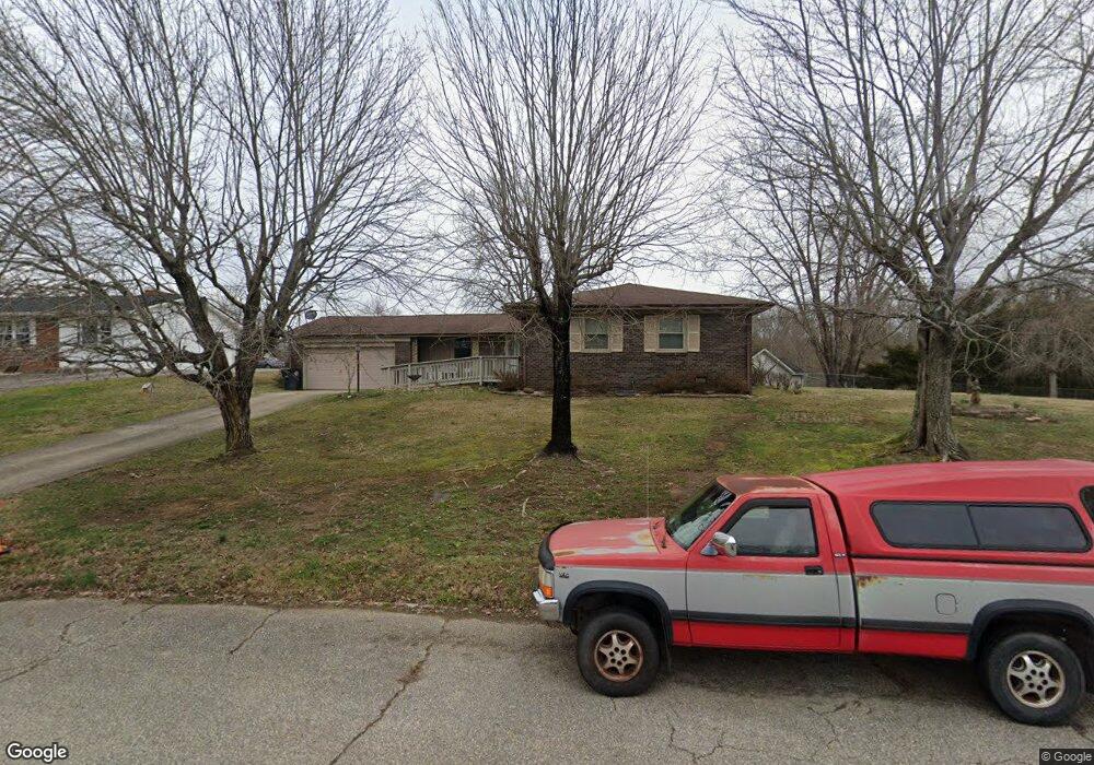
124 Aurawood Dr Kingsport, TN 37660
Estimated Value: $233,233 - $326,000
3
Beds
2
Baths
1,605
Sq Ft
$179/Sq Ft
Est. Value
About This Home
This home is located at 124 Aurawood Dr, Kingsport, TN 37660 and is currently estimated at $287,558, approximately $179 per square foot. 124 Aurawood Dr is a home located in Sullivan County with nearby schools including Thomas Jefferson Elementary School, Ross N. Robinson Middle School, and Dobyns-Bennett High School.
Ownership History
Date
Name
Owned For
Owner Type
Purchase Details
Closed on
Dec 11, 2020
Sold by
Starnes Melinda
Bought by
Starnes Grover
Current Estimated Value
Purchase Details
Closed on
Sep 20, 2004
Sold by
Brown Steve R and Brown Karen
Bought by
Grove Starnes
Home Financials for this Owner
Home Financials are based on the most recent Mortgage that was taken out on this home.
Original Mortgage
$105,000
Outstanding Balance
$51,498
Interest Rate
5.73%
Estimated Equity
$236,060
Purchase Details
Closed on
Dec 19, 1998
Create a Home Valuation Report for This Property
The Home Valuation Report is an in-depth analysis detailing your home's value as well as a comparison with similar homes in the area
Home Values in the Area
Average Home Value in this Area
Purchase History
| Date | Buyer | Sale Price | Title Company |
|---|---|---|---|
| Starnes Grover | -- | None Available | |
| Grove Starnes | $105,000 | -- | |
| -- | $87,000 | -- |
Source: Public Records
Mortgage History
| Date | Status | Borrower | Loan Amount |
|---|---|---|---|
| Open | -- | $105,000 |
Source: Public Records
Tax History Compared to Growth
Tax History
| Year | Tax Paid | Tax Assessment Tax Assessment Total Assessment is a certain percentage of the fair market value that is determined by local assessors to be the total taxable value of land and additions on the property. | Land | Improvement |
|---|---|---|---|---|
| 2024 | -- | $37,400 | $5,100 | $32,300 |
| 2023 | $1,647 | $37,400 | $5,100 | $32,300 |
| 2022 | $1,647 | $37,400 | $5,100 | $32,300 |
| 2021 | $1,602 | $37,400 | $5,100 | $32,300 |
| 2020 | $901 | $37,400 | $5,100 | $32,300 |
| 2019 | $1,625 | $35,075 | $5,100 | $29,975 |
| 2018 | $1,587 | $35,075 | $5,100 | $29,975 |
| 2017 | $1,587 | $35,075 | $5,100 | $29,975 |
| 2016 | $1,409 | $30,325 | $5,100 | $25,225 |
| 2014 | $1,326 | $30,311 | $0 | $0 |
Source: Public Records
Map
Nearby Homes
- Tbd Norma Dr
- 5079 Rose Gardens Cir
- 2804 Carrollwood Heights Rd
- 1001 Sunny Place
- 1000 Windridge Dr
- Tbd E Stone Dr
- 3130 E Stone Dr
- 400 Bancroft Chapel Rd
- 712 New Beason Well Rd
- Tbd Bancroft Chapel Rd
- 569 Bancroft Chapel Rd
- 503 New Beason Well Rd
- 2733 Prestwick Ct
- 1764 Buckingham Ct
- 3300 Grandview Dr
- 132 Packing House Rd
- 4416 Beechcliff Dr
- 0 Orebank Rd Unit 11537999
- 0 Orebank Rd Unit 307463
- 313 Milburn Ave
- 305 Norma Dr
- 128 Aurawood Dr
- 120 Aurawood Dr
- 125 Aurawood Dr
- 309 Norma Dr
- 133 Aurawood Dr
- Lot 3 Aurawood Dr
- 132 Aurawood Dr
- 313 Norma Dr
- 308 Norma Dr
- 141 Aurawood Dr
- 112 Aurawood Dr
- 169 Aurawood Dr
- 140 Aurawood Dr
- 117 Aurawood Dr
- 317 Norma Dr
- 145 Aurawood Dr
- 108 Aurawood Dr
- 316 Norma Dr
- 213 Joann Dr