

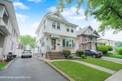
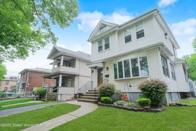
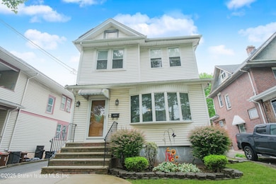
124 Bancroft Ave Staten Island, NY 10306
New Dorp NeighborhoodEstimated payment $5,057/month
Total Views
1,142
3
Beds
2
Baths
1,324
Sq Ft
$604
Price per Sq Ft
Highlights
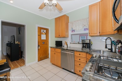
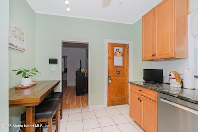
- Eat-In Kitchen
- 3-minute walk to Grant City
- Combination Dining and Living Room
- New Dorp High School Rated A-
- Cooling Available
- Hot Water Baseboard Heater
About This Home
Welcome to this beautifully maintained SINGLE FAMILY 3-bedroom, 2-bathroom, nestled in the highly sought-after New Dorp section of Staten Island. Perfectly situated on a spacious 4,000 sq ft. Step inside to find generous living space with updates throughout. The outdoor space is truly a private oasis—featuring a stunning inground pool, elegant pavers, and a low-maintenance Trex deck—ideal for relaxing or entertaining guests all summer long. Located just minutes from the Staten Island Railroad, multiple local and express bus lines, and all the shopping, dining, and amenities Hyland Boulevard has to offer. This home combines suburban tranquility with unbeatable accessibility. Don't miss your chance to own this gem in one of Staten Island's most desirable neighborhoods!
Listing Agent
Thomas Gugliucci Real Estate License #10401323820 Listed on: 06/16/2025
Property Details
Home Type
- Multi-Family
Est. Annual Taxes
- $7,513
Year Built
- Built in 1930
Lot Details
- 4,000 Sq Ft Lot
- Lot Dimensions are 22x24
Home Design
- Duplex
- Vinyl Siding
Interior Spaces
- 1,324 Sq Ft Home
- 2-Story Property
- Combination Dining and Living Room
- Eat-In Kitchen
Bedrooms and Bathrooms
- 3 Bedrooms
- 2 Full Bathrooms
Parking
- On-Street Parking
- Off-Street Parking
Utilities
- Cooling Available
- Heating System Uses Natural Gas
- Hot Water Baseboard Heater
- 220 Volts
- Individual Gas Meter
Community Details
- 2 Units
Listing and Financial Details
- Legal Lot and Block 0040 / 03607
- Assessor Parcel Number 03607-0040
Map
Create a Home Valuation Report for This Property
The Home Valuation Report is an in-depth analysis detailing your home's value as well as a comparison with similar homes in the area
Home Values in the Area
Average Home Value in this Area
Tax History
| Year | Tax Paid | Tax Assessment Tax Assessment Total Assessment is a certain percentage of the fair market value that is determined by local assessors to be the total taxable value of land and additions on the property. | Land | Improvement |
|---|---|---|---|---|
| 2025 | $7,117 | $51,180 | $9,561 | $41,619 |
| 2024 | $4,403 | $44,460 | $10,424 | $34,036 |
| 2023 | $4,075 | $33,427 | $10,093 | $23,334 |
| 2022 | $6,296 | $39,180 | $13,080 | $26,100 |
| 2021 | $6,637 | $35,400 | $13,080 | $22,320 |
| 2020 | $9,642 | $33,960 | $13,080 | $20,880 |
| 2019 | $11,449 | $32,100 | $13,080 | $19,020 |
| 2018 | $5,678 | $27,856 | $11,678 | $16,178 |
| 2017 | $5,357 | $26,280 | $11,412 | $14,868 |
| 2016 | $5,254 | $26,280 | $12,320 | $13,960 |
| 2015 | $4,722 | $25,980 | $10,920 | $15,060 |
| 2014 | $4,722 | $24,606 | $10,342 | $14,264 |
Source: Public Records
Property History
| Date | Event | Price | Change | Sq Ft Price |
|---|---|---|---|---|
| 06/27/2025 06/27/25 | Pending | -- | -- | -- |
| 06/16/2025 06/16/25 | For Sale | $799,999 | -- | $604 / Sq Ft |
Source: Staten Island Multiple Listing Service
Purchase History
| Date | Type | Sale Price | Title Company |
|---|---|---|---|
| Interfamily Deed Transfer | -- | -- | |
| Bargain Sale Deed | -- | -- | |
| Interfamily Deed Transfer | -- | -- |
Source: Public Records
Mortgage History
| Date | Status | Loan Amount | Loan Type |
|---|---|---|---|
| Open | $25,000 | Credit Line Revolving | |
| Open | $100,000 | Credit Line Revolving |
Source: Public Records
Similar Homes in the area
Source: Staten Island Multiple Listing Service
MLS Number: 2503478
APN: 03607-0040
Disclaimer: Certain information contained herein is derived from information provided by parties other than Homes.com. All information provided is deemed reliable, but is not guaranteed to be accurate and should be independently verified.
![]() Certain real estate listing data is provided by Staten Island MLS under its Internet Data Exchange program. This data is provided exclusively for consumers’ personal, non-commercial use and may only be used for identifying prospective properties consumers may be interested in purchasing or renting. Any other use of the data is hereby prohibited. Data deemed reliable but is not guaranteed accurate by Staten Island MLS and should be independently verified. Copyright 2025 Staten Island Multiple Listing Service, Inc. All rights reserved.
Certain real estate listing data is provided by Staten Island MLS under its Internet Data Exchange program. This data is provided exclusively for consumers’ personal, non-commercial use and may only be used for identifying prospective properties consumers may be interested in purchasing or renting. Any other use of the data is hereby prohibited. Data deemed reliable but is not guaranteed accurate by Staten Island MLS and should be independently verified. Copyright 2025 Staten Island Multiple Listing Service, Inc. All rights reserved.
Nearby Homes
- 122 Prescott Ave
- 183 Edison St
- 200 Bryant Ave
- 202 Bryant Ave
- 103 Otis Ave
- 142 Fremont Ave
- 217 Bancroft Ave
- 15 Allison Place
- 24 Bancroft Ave
- 23 Bancroft Ave
- 164 Burbank Ave
- 190 Burbank Ave
- 77 Burbank Ave
- 145 Lincoln Ave Unit 6X
- 145 Lincoln Ave Unit 1K
- 145 Lincoln Ave Unit 2H
- 145 Lincoln Ave Unit 4E
- 145 Lincoln Ave Unit 1V
- 145 Lincoln Ave Unit 1P
- 145 Lincoln Ave Unit 6J