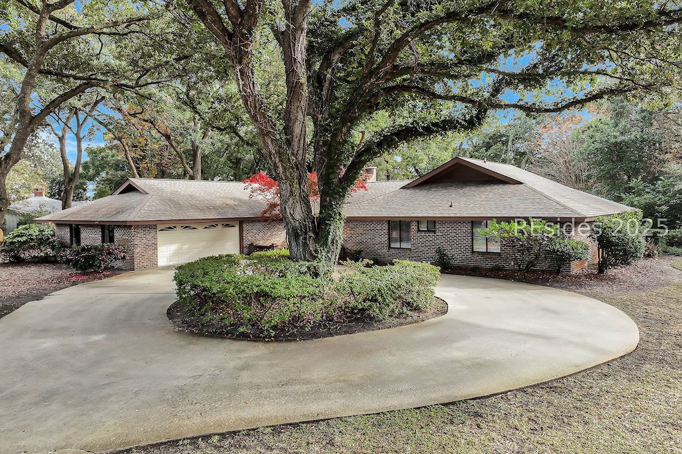


124 Coggins Point Rd Hilton Head Island, SC 29928
Port Royal Plantation NeighborhoodEstimated payment $6,578/month
Highlights
- Golf Course View
- Cathedral Ceiling
- Attic
- Hilton Head Island High School Rated A-
- Engineered Wood Flooring
- Community Pool
About This Home
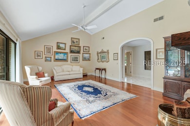
Tucked into the heart of Port Royal Plantation just .3 miles from the private beach path, this classic single-story brick home rests on an exceptional .704-acre lot, shaded by magnificent specimen live oak trees overlooking the 15th green of the Barony Course. The setting feels timeless & unmistakably Low-country, complete with a private pool perfect for morning swims, impromptu gatherings, & sunset evenings.Inside, smooth vaulted ceilings & abundant natural light create a bright, welcoming canvas. 3BR/3.5BA, 2,562 sq ft, and a 2-car garage, the layout offers wonderful bone & flexibility-ideal for reimagining spaces & adding personal style at your own pace. Thoughtfully maintained, the home includes a 2021 roof and enjoys the added peace of mind of an X flood zone.Port Royal Plantation is a private oceanfront community known for its warmth, beauty, & enduring appeal. Owners enjoy leisure trails, fire pits, private beaches, an oceanfront pool & beach house, tennis, pickleball, and 24-hour security. No short-term rentals, and optional membership to the semi-private Port Royal Golf Club preserve the community's easygoing, residential feel.A rare opportunity to blend location, lot size, and imagination-this is a home where thoughtful updates can meet timeless surroundings, and the next chapter can be truly special.
Home Details
Home Type
- Single Family
Est. Annual Taxes
- $3,817
Year Built
- Built in 1983
Lot Details
- 0.7 Acre Lot
- Sprinkler System
Parking
- 2 Car Garage
Property Views
- Golf Course
- Pool
Home Design
- Brick Exterior Construction
- Asphalt Roof
- Tile
Interior Spaces
- 2,562 Sq Ft Home
- 1-Story Property
- Smooth Ceilings
- Cathedral Ceiling
- Ceiling Fan
- Fireplace
- Living Room
- Dining Room
- Utility Room
- Pull Down Stairs to Attic
Kitchen
- Eat-In Kitchen
- Microwave
- Dishwasher
- Disposal
Flooring
- Engineered Wood
- Carpet
Bedrooms and Bathrooms
- 3 Bedrooms
- Separate Shower
Laundry
- Laundry Room
- Dryer
- Washer
Outdoor Features
- Outdoor Shower
- Patio
Utilities
- Central Heating and Cooling System
Listing and Financial Details
- Tax Lot 4
- Assessor Parcel Number R510 009 000 0542 0000
Community Details
Amenities
- Community Garden
- Community Fire Pit
- Picnic Area
Recreation
- Tennis Courts
- Community Basketball Court
- Pickleball Courts
- Community Playground
- Community Pool
- Trails
Additional Features
- Sec 2N Subdivision
- Security Guard
Map
Home Values in the Area
Average Home Value in this Area
Tax History
| Year | Tax Paid | Tax Assessment Tax Assessment Total Assessment is a certain percentage of the fair market value that is determined by local assessors to be the total taxable value of land and additions on the property. | Land | Improvement |
|---|---|---|---|---|
| 2024 | $3,817 | $47,636 | $15,600 | $32,036 |
| 2023 | $3,842 | $47,636 | $15,600 | $32,036 |
| 2022 | $3,490 | $26,032 | $13,000 | $13,032 |
| 2021 | $10,389 | $26,032 | $13,000 | $13,032 |
| 2020 | $3,577 | $26,032 | $13,000 | $13,032 |
| 2019 | $3,387 | $26,032 | $13,000 | $13,032 |
| 2018 | $3,318 | $26,030 | $0 | $0 |
| 2017 | $3,084 | $23,950 | $0 | $0 |
| 2016 | $2,861 | $23,950 | $0 | $0 |
| 2014 | $3,020 | $23,950 | $0 | $0 |
Property History
| Date | Event | Price | List to Sale | Price per Sq Ft |
|---|---|---|---|---|
| 11/26/2025 11/26/25 | Price Changed | $1,189,000 | 0.0% | $464 / Sq Ft |
| 11/26/2025 11/26/25 | For Sale | $1,189,000 | -- | $464 / Sq Ft |
| 11/25/2025 11/25/25 | Off Market | -- | -- | -- |
Purchase History
| Date | Type | Sale Price | Title Company |
|---|---|---|---|
| Interfamily Deed Transfer | -- | None Available |
Mortgage History
| Date | Status | Loan Amount | Loan Type |
|---|---|---|---|
| Closed | $937,500 | Reverse Mortgage Home Equity Conversion Mortgage |
Source: REsides
MLS Number: 503047
APN: R510-009-000-0542-0000
Disclaimer: Certain information contained herein is derived from information provided by parties other than Homes.com. All information provided is deemed reliable, but is not guaranteed to be accurate and should be independently verified.
![]() We do not attempt to independently verify the currency, completeness, accuracy or authenticity of the data contained herein. All area measurements and calculations are approximate and should be independently verified. Data may be subject to transcription and transmission errors. Accordingly, the data is provided on an “as is” “as available” basis only and may not reflect all real estate activity in the market”. © [2025] REsides, Inc. All rights reserved. Certain information contained herein is derived from information, which is the licensed property of, and copyrighted by, REsides, Inc.
We do not attempt to independently verify the currency, completeness, accuracy or authenticity of the data contained herein. All area measurements and calculations are approximate and should be independently verified. Data may be subject to transcription and transmission errors. Accordingly, the data is provided on an “as is” “as available” basis only and may not reflect all real estate activity in the market”. © [2025] REsides, Inc. All rights reserved. Certain information contained herein is derived from information, which is the licensed property of, and copyrighted by, REsides, Inc.
- 2 Sherman Dr
- 20 Fairway Winds Place
- 43 Scarborough Head Rd
- 5 Princeton Cir
- 98 S Port Royal Dr
- 28 Planters Row
- 22 Sovereign Dr
- 85 S Port Royal Dr
- 33 N Port Royal Dr
- 20 Royal Crest Dr
- 11 Dahlgren Ln
- 4 Heyward Place
- 17 Dahlgren Ln
- 2 Resolute Place
- 3 Claire Dr
- 65 N Port Royal Dr
- 2 Wimbledon Ct Unit 209
- 2 Wimbledon Ct Unit 205
- 3 Wimbledon Ct Unit 104
- 3 Wimbledon Ct Unit 204
- 85 Folly Field Rd Unit ID1316236P
- 45 Folly Field Rd Unit ID1316251P
- 239 Beach City Rd Unit ID1316239P
- 239 Beach City Rd Unit 3319
- 40 Folly Field Rd
- 40 Folly Field Rd Unit ID1316233P
- 100 Mathews Dr Unit 7
- 40 Folly Field Rd Unit HHIBTR #AR416
- 52 Sandcastle Ct Unit ID1316234P
- 400 William Hilton Pkwy Unit ID1309198P
- 400 William Hilton Pkwy Unit ID1309203P
- 400 William Hilton Pkwy Unit ID1309199P
- 400 William Hilton Pkwy Unit ID1309197P
- 55 Gardner Dr
- 10 Surf Watch Way
- 55 Gardner Dr Unit B1
- 55 Gardner Dr Unit A1
- 55 Gardner Dr Unit A2
- 3 Collier Ct Unit ID1316246P
- 100 Marsh Point Dr
