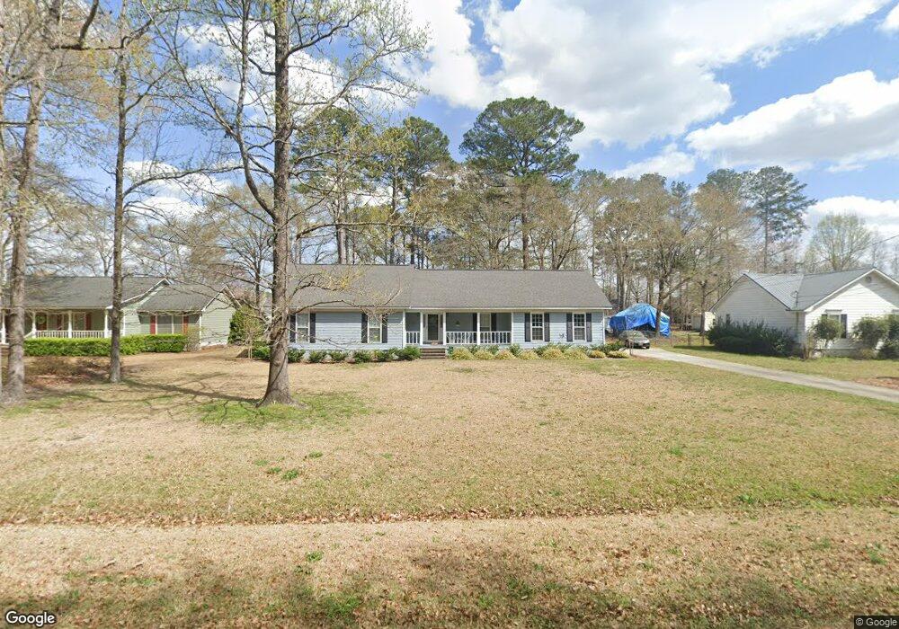
124 Francis Dr Macon, GA 31216
Estimated Value: $224,139 - $250,000
3
Beds
2
Baths
1,660
Sq Ft
$144/Sq Ft
Est. Value
About This Home
This home is located at 124 Francis Dr, Macon, GA 31216 and is currently estimated at $238,285, approximately $143 per square foot. 124 Francis Dr is a home located in Bibb County with nearby schools including Heard Elementary School, Rutland Middle School, and Rutland High School.
Ownership History
Date
Name
Owned For
Owner Type
Purchase Details
Closed on
Feb 27, 2006
Sold by
Atkinson John G
Bought by
Atkinson Tami T
Current Estimated Value
Home Financials for this Owner
Home Financials are based on the most recent Mortgage that was taken out on this home.
Original Mortgage
$94,000
Interest Rate
6.05%
Mortgage Type
New Conventional
Create a Home Valuation Report for This Property
The Home Valuation Report is an in-depth analysis detailing your home's value as well as a comparison with similar homes in the area
Home Values in the Area
Average Home Value in this Area
Purchase History
| Date | Buyer | Sale Price | Title Company |
|---|---|---|---|
| Atkinson Tami T | -- | None Avilabale |
Source: Public Records
Mortgage History
| Date | Status | Borrower | Loan Amount |
|---|---|---|---|
| Closed | Atkinson Tami T | $94,000 |
Source: Public Records
Tax History Compared to Growth
Tax History
| Year | Tax Paid | Tax Assessment Tax Assessment Total Assessment is a certain percentage of the fair market value that is determined by local assessors to be the total taxable value of land and additions on the property. | Land | Improvement |
|---|---|---|---|---|
| 2025 | $1,785 | $79,622 | $8,480 | $71,142 |
| 2024 | $1,752 | $75,987 | $8,480 | $67,507 |
| 2023 | $1,582 | $60,408 | $8,480 | $51,928 |
| 2022 | $1,448 | $48,810 | $6,678 | $42,132 |
| 2021 | $1,589 | $48,810 | $6,678 | $42,132 |
| 2020 | $1,449 | $44,312 | $6,010 | $38,302 |
| 2019 | $1,386 | $42,397 | $6,010 | $36,387 |
| 2018 | $2,147 | $39,814 | $5,342 | $34,472 |
| 2017 | $1,229 | $39,814 | $5,342 | $34,472 |
| 2016 | $1,135 | $39,814 | $5,342 | $34,472 |
| 2015 | $1,593 | $39,528 | $5,342 | $34,186 |
| 2014 | $1,689 | $41,428 | $5,342 | $36,085 |
Source: Public Records
Map
Nearby Homes
- 126 Francis Dr
- 122 Francis Dr
- 117 Alan Ct
- 119 Alan Ct
- 128 Francis Dr
- 115 Alan Ct
- 120 Francis Dr
- 125 Francis Dr
- 127 Francis Dr
- 121 Alan Ct
- 121 Francis Dr
- 111 Alan Ct
- 129 Francis Dr
- 119 Francis Dr
- 123 Alan Ct
- 118 Francis Dr
- 118 Alan Ct
- 118 Alan Ct Unit 110-3
- 0 Alan Ct Unit 8403108
- 0 Alan Ct Unit 7218698