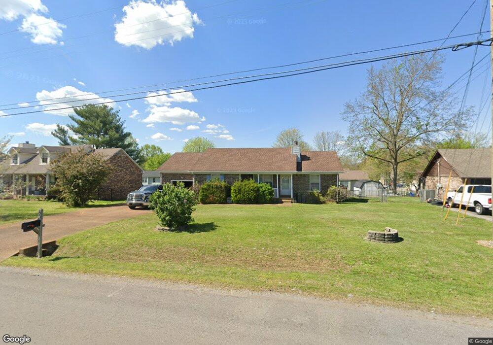
124 Noel Ln Smyrna, TN 37167
Estimated Value: $292,415 - $347,000
--
Bed
2
Baths
1,335
Sq Ft
$238/Sq Ft
Est. Value
About This Home
This home is located at 124 Noel Ln, Smyrna, TN 37167 and is currently estimated at $318,354, approximately $238 per square foot. 124 Noel Ln is a home located in Rutherford County with nearby schools including David Youree Elementary School, Rocky Fork Middle School, and Smyrna High School.
Ownership History
Date
Name
Owned For
Owner Type
Purchase Details
Closed on
Jan 10, 2002
Sold by
Nations Grady W and Nations Michele
Bought by
William Starling
Current Estimated Value
Home Financials for this Owner
Home Financials are based on the most recent Mortgage that was taken out on this home.
Original Mortgage
$115,983
Outstanding Balance
$50,648
Interest Rate
6.72%
Estimated Equity
$267,706
Purchase Details
Closed on
May 4, 1998
Sold by
Anderson Grady E
Bought by
Grady Nations
Purchase Details
Closed on
Aug 9, 1994
Sold by
Prince David V
Bought by
Anderson Grady E
Create a Home Valuation Report for This Property
The Home Valuation Report is an in-depth analysis detailing your home's value as well as a comparison with similar homes in the area
Home Values in the Area
Average Home Value in this Area
Purchase History
| Date | Buyer | Sale Price | Title Company |
|---|---|---|---|
| William Starling | $116,900 | -- | |
| Grady Nations | $94,500 | -- | |
| Anderson Grady E | -- | -- |
Source: Public Records
Mortgage History
| Date | Status | Borrower | Loan Amount |
|---|---|---|---|
| Open | Anderson Grady E | $115,983 |
Source: Public Records
Tax History Compared to Growth
Tax History
| Year | Tax Paid | Tax Assessment Tax Assessment Total Assessment is a certain percentage of the fair market value that is determined by local assessors to be the total taxable value of land and additions on the property. | Land | Improvement |
|---|---|---|---|---|
| 2025 | $1,627 | $67,750 | $13,750 | $54,000 |
| 2024 | $1,627 | $67,750 | $13,750 | $54,000 |
| 2023 | $1,627 | $67,750 | $13,750 | $54,000 |
| 2022 | $1,451 | $67,750 | $13,750 | $54,000 |
| 2021 | $1,374 | $47,050 | $8,750 | $38,300 |
| 2020 | $1,374 | $47,050 | $8,750 | $38,300 |
| 2019 | $1,374 | $47,050 | $8,750 | $38,300 |
| 2018 | $1,318 | $47,050 | $0 | $0 |
| 2017 | $1,165 | $32,675 | $0 | $0 |
| 2016 | $1,165 | $32,675 | $0 | $0 |
| 2015 | $1,165 | $32,675 | $0 | $0 |
| 2014 | $813 | $32,675 | $0 | $0 |
| 2013 | -- | $33,725 | $0 | $0 |
Source: Public Records
Map
Nearby Homes
- 304 Short Ct
- 105 Pleasant Dr
- 104 Pleasant Dr
- 4344 Spregan Way
- 4372 Spregan Way
- 400 Highland Ave
- 143 Stokes Dr
- 101 Richland Ave
- 107 Irish Place
- 101 Annleeken Dr
- 726 Mason Tucker Dr
- Caroline Plan at Spring Branch - Townhomes
- Bruckner Plan at Spring Branch - Townhomes
- Mozart Plan at Spring Branch - Townhomes
- 1226 Bronte Dr Unit 23D
- 1222 Bronte Dr Unit 23C
- 1226 Bronte Dr
- 4018 Gaskill Dr
- 4026 Gaskill Dr Unit 118D
- 4042 Gaskill Dr Unit 113C