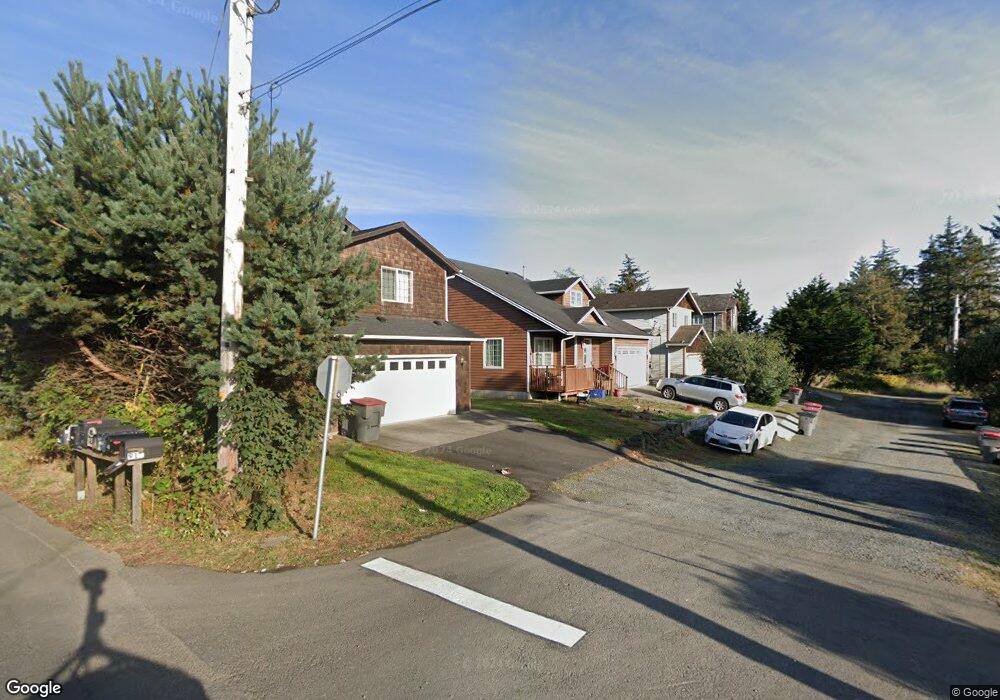
1240 Queen St Seaside, OR 97138
Stanley Acres NeighborhoodEstimated Value: $484,000 - $550,000
3
Beds
3
Baths
1,940
Sq Ft
$267/Sq Ft
Est. Value
About This Home
This home is located at 1240 Queen St, Seaside, OR 97138 and is currently estimated at $517,199, approximately $266 per square foot. 1240 Queen St is a home located in Clatsop County with nearby schools including Seaside High School.
Ownership History
Date
Name
Owned For
Owner Type
Purchase Details
Closed on
May 13, 2013
Sold by
Bank Of America Na
Bought by
Wang Frank N
Current Estimated Value
Purchase Details
Closed on
Mar 29, 2012
Sold by
Bank Of America Na
Bought by
Federal Home Loan Mortgage Corporation
Purchase Details
Closed on
Feb 13, 2012
Sold by
Andersson Ronald William
Bought by
Bank Of America N A
Purchase Details
Closed on
Apr 11, 2006
Sold by
Adamson Peter J
Bought by
Andersson Ronald William
Create a Home Valuation Report for This Property
The Home Valuation Report is an in-depth analysis detailing your home's value as well as a comparison with similar homes in the area
Home Values in the Area
Average Home Value in this Area
Purchase History
| Date | Buyer | Sale Price | Title Company |
|---|---|---|---|
| Wang Frank N | $180,399 | Ticor Title Ins Co | |
| Federal Home Loan Mortgage Corporation | -- | Accommodation | |
| Bank Of America N A | $212,500 | None Available | |
| Andersson Ronald William | $60,000 | Ticor Title Ins Co |
Source: Public Records
Tax History
| Year | Tax Paid | Tax Assessment Tax Assessment Total Assessment is a certain percentage of the fair market value that is determined by local assessors to be the total taxable value of land and additions on the property. | Land | Improvement |
|---|---|---|---|---|
| 2022 | $3,209 | $223,075 | $0 | $0 |
| 2018 | $2,866 | $198,202 | $0 | $0 |
| 2017 | $2,735 | $192,430 | $0 | $0 |
| 2016 | $2,406 | $186,826 | $17,817 | $169,009 |
| 2015 | $2,343 | $181,386 | $17,299 | $164,087 |
| 2014 | $2,336 | $176,104 | $0 | $0 |
| 2013 | -- | $170,975 | $0 | $0 |
Source: Public Records
Map
Nearby Homes
- 1350 13th Ave
- 0 N Wahanna Rd
- 1299 6th Ave
- 811 17th Ave
- 1110 6th Ave
- 790 17th Ave
- 1000 N Holladay Dr Unit 402
- 1000 N Holladay Dr
- 1000 N Holladay Dr Unit 304
- 815 N King St
- 481 Hillside Loop
- 2270 Skyline Dr
- 321 N Holladay Dr
- 0 Cross Creek St Unit 12
- 0 Cross Creek St Unit 10
- 0 Cross Creek St Unit 11
- 0 Cross Creek St Unit 26-112
- 0 Cross Creek St Unit 13
- 0 Cross Creek St Unit 26-114
- 0 Cross Creek St Unit 26-115
- 1220 Queen St
- 1260 Queen St
- 1320 12th Ave
- 1325 12th Ave
- 1342 12th Ave
- 1160 Queen St
- 1165 Queen St
- 0 Vacant Land Unit 159249124
- 0 Broadway and Wahanna Unit 22127593
- 0 N Vacant Land 12th Ave Unit 19-803
- 0 N Vacant Land 12th Ave Unit 19427475
- 1355 13th Ave
- 1352 12th Ave
- 1403 12th Ave
- 1100 Queen St
- Lot 1 Queen
- North of 1120 Queen
- 1362 12th Ave
- 1340 13th Ave
- 1361 13th Ave
Your Personal Tour Guide
Ask me questions while you tour the home.