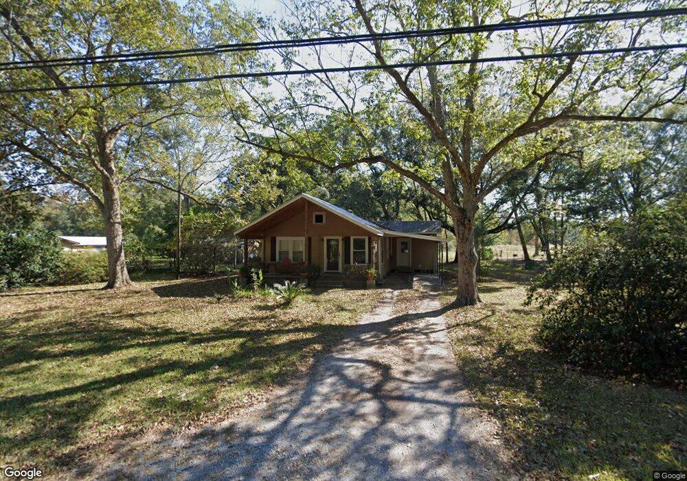
12408 Lily Orchard Rd Moss Point, MS 39562
Estimated Value: $109,000 - $117,254
--
Bed
1
Bath
1,146
Sq Ft
$100/Sq Ft
Est. Value
About This Home
This home is located at 12408 Lily Orchard Rd, Moss Point, MS 39562 and is currently estimated at $114,418, approximately $99 per square foot. 12408 Lily Orchard Rd is a home located in Jackson County with nearby schools including East Central Lower Elementary School, East Central Upper Elementary School, and East Central Middle School.
Ownership History
Date
Name
Owned For
Owner Type
Purchase Details
Closed on
Dec 30, 2022
Sold by
Tyler Patrick John
Bought by
Altstatt Rickey Alan and Altstatt Marsha K
Current Estimated Value
Purchase Details
Closed on
Feb 11, 2022
Sold by
Frances Taylor Joy
Bought by
Patrick John Tyler
Purchase Details
Closed on
Dec 17, 2021
Sold by
Eugene Beasley Robert
Bought by
Taylor Joy Frances and Stokley Ashleigh J
Purchase Details
Closed on
Dec 17, 2012
Sold by
Beasley Robert E
Bought by
Beasley Robert Eugene
Create a Home Valuation Report for This Property
The Home Valuation Report is an in-depth analysis detailing your home's value as well as a comparison with similar homes in the area
Home Values in the Area
Average Home Value in this Area
Purchase History
| Date | Buyer | Sale Price | Title Company |
|---|---|---|---|
| Altstatt Rickey Alan | -- | -- | |
| Patrick John Tyler | -- | Island Winds Title | |
| Patrick John Tyler | -- | Island Winds Title | |
| Taylor Joy Frances | -- | New Title Company Name | |
| Beasley Robert Eugene | -- | -- |
Source: Public Records
Tax History Compared to Growth
Tax History
| Year | Tax Paid | Tax Assessment Tax Assessment Total Assessment is a certain percentage of the fair market value that is determined by local assessors to be the total taxable value of land and additions on the property. | Land | Improvement |
|---|---|---|---|---|
| 2024 | $58 | $5,345 | $1,883 | $3,462 |
| 2023 | $58 | $5,363 | $1,901 | $3,462 |
| 2022 | $44 | $4,688 | $0 | $0 |
| 2021 | $48 | $4,740 | $3,686 | $1,054 |
| 2020 | $46 | $4,724 | $1,588 | $3,136 |
| 2019 | $64 | $5,019 | $1,613 | $3,406 |
| 2018 | $65 | $5,041 | $1,635 | $3,406 |
| 2017 | $68 | $5,051 | $1,633 | $3,418 |
| 2016 | $65 | $5,008 | $1,579 | $3,429 |
| 2015 | $71 | $43,560 | $12,380 | $31,180 |
| 2014 | $79 | $4,844 | $1,535 | $3,309 |
| 2013 | $82 | $4,866 | $1,504 | $3,362 |
Source: Public Records
Map
Nearby Homes
- 0 Dunn Unit 4117818
- 8537 Augusta Rd
- 13109 Oak Haven Dr
- 14416 Lily Orchard Rd
- 10312 Kevin Dr
- 7975 Revolutionary Rd
- 0 Forts Lake Rd Unit 3365580
- 0 Forts Lake Rd Unit 3365577
- 15454 Constitution Rd
- 0 King Rd Unit 4107640
- 8313 Coda Rd
- 0 Ms-613 Hwy Unit 4116583
- 0 Ms-613 Hwy Unit 4107607
- 0 Ms-613 Hwy Unit 4107612
- 0 Ms-613 Hwy Unit 4116582
- 6112 Hans Rd
- 13524 Highway 613
- 0 Shiprock St
- 6301 Pioneer Trail
- 0 Constitution
- 9417 Broadus Rd Unit DRO
- 12320 Lily Orchard Rd
- 5.76 Acres Lily Orchard Rd
- 9523 Broadus Rd
- 12300 Lily Orchard Rd
- Nhn Clarence Furby Rd
- 12229 Lily Orchard Rd
- 12223 Lily Orchard Rd
- 9301 Broadus Rd
- 9314 Broadus Rd
- 9804 Clarence Furby Rd
- 12227 Lily Orchard Rd
- 12014 Lily Orchard Rd
- 9101 Nutbank Rd
- 12225 Lily Orchard Rd
- 8980 Nutbank Rd
- 12224 Lily Orchard Rd
- 9731 Clarence Furby Rd
- 12832 Lily Orchard Rd
- 9200 Nutbank Rd