Estimated Value: $156,000 - $168,000
3
Beds
1
Bath
960
Sq Ft
$171/Sq Ft
Est. Value
About This Home
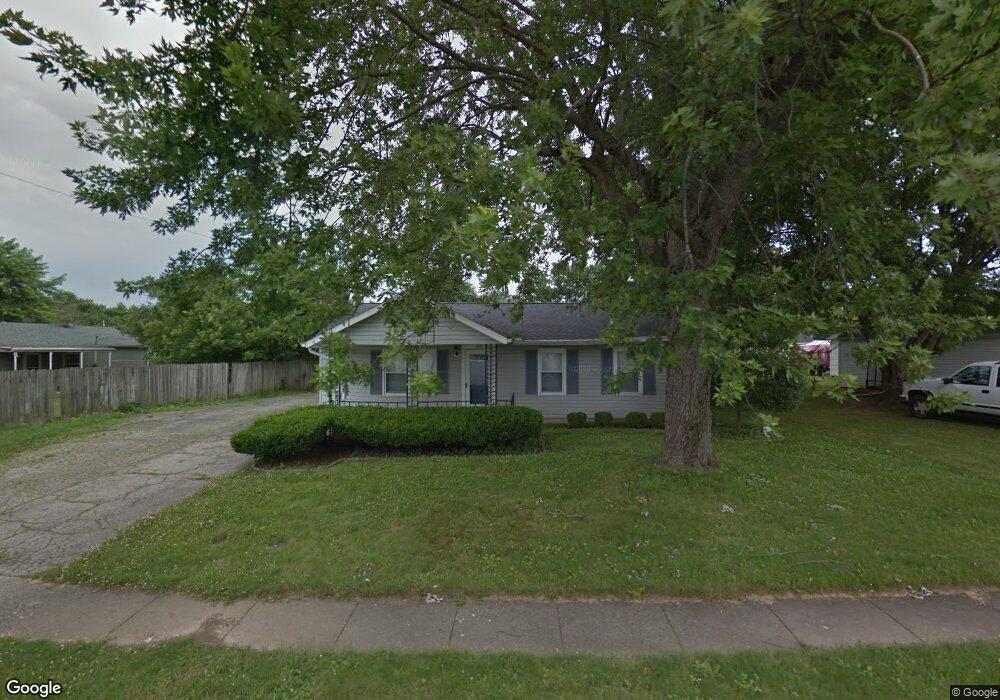
This home is located at 1243 Omard Dr, Xenia, OH 45385 and is currently estimated at $163,953, approximately $170 per square foot. 1243 Omard Dr is a home located in Greene County with nearby schools including Xenia High School, Summit Academy Community School for Alternative Learners - Xenia, and Legacy Christian Academy.
Ownership History
Date
Name
Owned For
Owner Type
Purchase Details
Closed on
Apr 9, 2018
Sold by
Kingsolver Jacob S and Kingsolver Mandy M
Bought by
Cannady Michelle R
Current Estimated Value
Home Financials for this Owner
Home Financials are based on the most recent Mortgage that was taken out on this home.
Original Mortgage
$75,200
Outstanding Balance
$64,671
Interest Rate
4.44%
Mortgage Type
New Conventional
Estimated Equity
$99,282
Purchase Details
Closed on
May 3, 2002
Sold by
Swigart Dawn and Swigart Thomas T
Bought by
Kingsolver Jacob S and Kingsolver Mandy M
Home Financials for this Owner
Home Financials are based on the most recent Mortgage that was taken out on this home.
Original Mortgage
$78,272
Interest Rate
7.24%
Mortgage Type
FHA
Create a Home Valuation Report for This Property
The Home Valuation Report is an in-depth analysis detailing your home's value as well as a comparison with similar homes in the area
Home Values in the Area
Average Home Value in this Area
Purchase History
| Date | Buyer | Sale Price | Title Company |
|---|---|---|---|
| Cannady Michelle R | $79,500 | None Available | |
| Kingsolver Jacob S | $79,500 | -- |
Source: Public Records
Mortgage History
| Date | Status | Borrower | Loan Amount |
|---|---|---|---|
| Open | Cannady Michelle R | $75,200 | |
| Previous Owner | Kingsolver Jacob S | $78,272 |
Source: Public Records
Tax History
| Year | Tax Paid | Tax Assessment Tax Assessment Total Assessment is a certain percentage of the fair market value that is determined by local assessors to be the total taxable value of land and additions on the property. | Land | Improvement |
|---|---|---|---|---|
| 2024 | $1,770 | $40,650 | $10,730 | $29,920 |
| 2023 | $1,739 | $40,650 | $10,730 | $29,920 |
| 2022 | $1,436 | $28,620 | $7,670 | $20,950 |
| 2021 | $1,455 | $28,620 | $7,670 | $20,950 |
| 2020 | $1,394 | $28,620 | $7,670 | $20,950 |
| 2019 | $1,101 | $21,280 | $5,450 | $15,830 |
| 2018 | $1,105 | $21,280 | $5,450 | $15,830 |
| 2017 | $1,047 | $21,280 | $5,450 | $15,830 |
| 2016 | $1,047 | $19,780 | $5,450 | $14,330 |
| 2015 | $1,050 | $19,780 | $5,450 | $14,330 |
| 2014 | $1,005 | $19,780 | $5,450 | $14,330 |
Source: Public Records
Map
Nearby Homes
- 1351 Omard Dr
- 883 Omard Dr
- 1528 June Dr
- 709 N West St
- 1777 Kylemore Dr
- 305-325 Bellbrook Ave
- 412 N King St
- Harmony Plan at Grandstone Trace
- Newcastle Plan at Grandstone Trace
- Pendleton Plan at Grandstone Trace
- Bellamy Plan at Grandstone Trace
- Chatham Plan at Grandstone Trace
- Holcombe Plan at Grandstone Trace
- 878 N Detroit St
- 1790 Palmer Ct
- 1796 Palmer Ct
- 1808 Palmer Ct
- 1010 Bellbrook Ave
- 311 W 3rd St
- 493 Hollywood Blvd
Your Personal Tour Guide
Ask me questions while you tour the home.