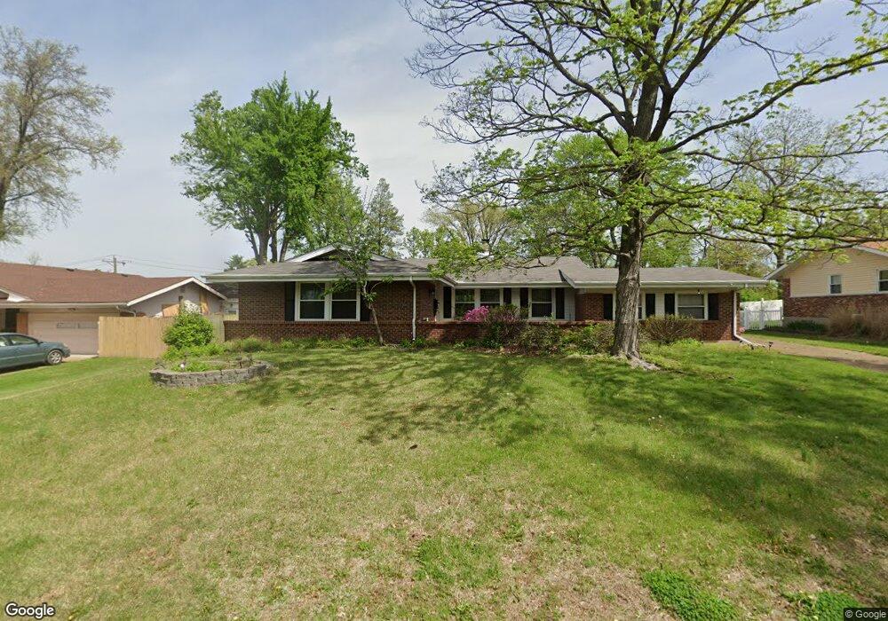
12433 Cape Cod Dr Saint Louis, MO 63146
Estimated Value: $323,470 - $383,000
3
Beds
2
Baths
1,717
Sq Ft
$210/Sq Ft
Est. Value
About This Home
This home is located at 12433 Cape Cod Dr, Saint Louis, MO 63146 and is currently estimated at $360,868, approximately $210 per square foot. 12433 Cape Cod Dr is a home located in St. Louis County with nearby schools including Ross Elementary School, Parkway Northeast Middle School, and Parkway North High School.
Ownership History
Date
Name
Owned For
Owner Type
Purchase Details
Closed on
Aug 3, 2012
Sold by
Friswold Paul J and Friswold Beatrice M
Bought by
Friswold Paul J and Friswold Beatrice M
Current Estimated Value
Purchase Details
Closed on
Apr 24, 1998
Sold by
Masterson Scott D and Masterson Nancy
Bought by
Friswold Paul J and Lutz Friswold Beatrice M
Home Financials for this Owner
Home Financials are based on the most recent Mortgage that was taken out on this home.
Original Mortgage
$131,850
Outstanding Balance
$25,007
Interest Rate
7.09%
Mortgage Type
Assumption
Estimated Equity
$335,861
Create a Home Valuation Report for This Property
The Home Valuation Report is an in-depth analysis detailing your home's value as well as a comparison with similar homes in the area
Home Values in the Area
Average Home Value in this Area
Purchase History
| Date | Buyer | Sale Price | Title Company |
|---|---|---|---|
| Friswold Paul J | -- | None Available | |
| Friswold Paul J | -- | -- |
Source: Public Records
Mortgage History
| Date | Status | Borrower | Loan Amount |
|---|---|---|---|
| Open | Friswold Paul J | $131,850 |
Source: Public Records
Tax History
| Year | Tax Paid | Tax Assessment Tax Assessment Total Assessment is a certain percentage of the fair market value that is determined by local assessors to be the total taxable value of land and additions on the property. | Land | Improvement |
|---|---|---|---|---|
| 2025 | $3,455 | $56,880 | $17,400 | $39,480 |
| 2024 | $3,455 | $52,740 | $13,070 | $39,670 |
| 2023 | $3,410 | $52,740 | $13,070 | $39,670 |
| 2022 | $3,159 | $44,520 | $13,070 | $31,450 |
| 2021 | $3,137 | $44,520 | $13,070 | $31,450 |
| 2020 | $3,109 | $42,140 | $15,770 | $26,370 |
| 2019 | $3,060 | $42,140 | $15,770 | $26,370 |
| 2018 | $2,837 | $36,040 | $11,320 | $24,720 |
| 2016 | $2,708 | $32,950 | $8,720 | $24,230 |
Source: Public Records
Map
Nearby Homes
- 12509 Larkwood Dr
- 1201 Ross Ave
- 12266 Ravelle Dr
- 1018 Tempo Dr
- 1056 King Carey Dr
- 12381 Merrick Dr
- 1503 Papillon Dr
- 12363 Merrick Dr
- 1639 Prestonpark Ln
- 842 N New Ballas Ct Unit 103
- 842 N New Ballas Ct Unit 102
- 950 E Rue de La Banque St Unit L6
- 12812 Portulaca Dr Unit I
- 950 E Rue de La Banque Unit 317
- 12818 Portulaca Dr Unit K
- 12205 Blackheath Ct
- 12842 Portulaca Dr Unit H
- 840 Angleterre Dr
- 1126 Rue La Chelle Walk Unit 1126
- 12725 Bennington Common Ln
- 12425 Cape Cod Dr
- 12441 Cape Cod Dr
- 16 Sunview Ln
- 12417 Cape Cod Dr
- 12432 Cape Cod Dr
- 15 Sunview Ln
- 17 Sunview Ln
- 12460 Cape Cod Dr
- 12424 Cape Cod Dr
- 12449 Cape Cod Dr
- 12457 Cape Cod Dr
- 12416 Cape Cod Dr
- 14 Sunview Ln
- 12409 Cape Cod Dr
- 18 Sunview Ln
- 12447 Betsy Ross Ln
- 12439 Betsy Ross Ln
- 12455 Cape Cod Dr
- 12465 Cape Cod Dr
- 12408 Cape Cod Dr
Your Personal Tour Guide
Ask me questions while you tour the home.