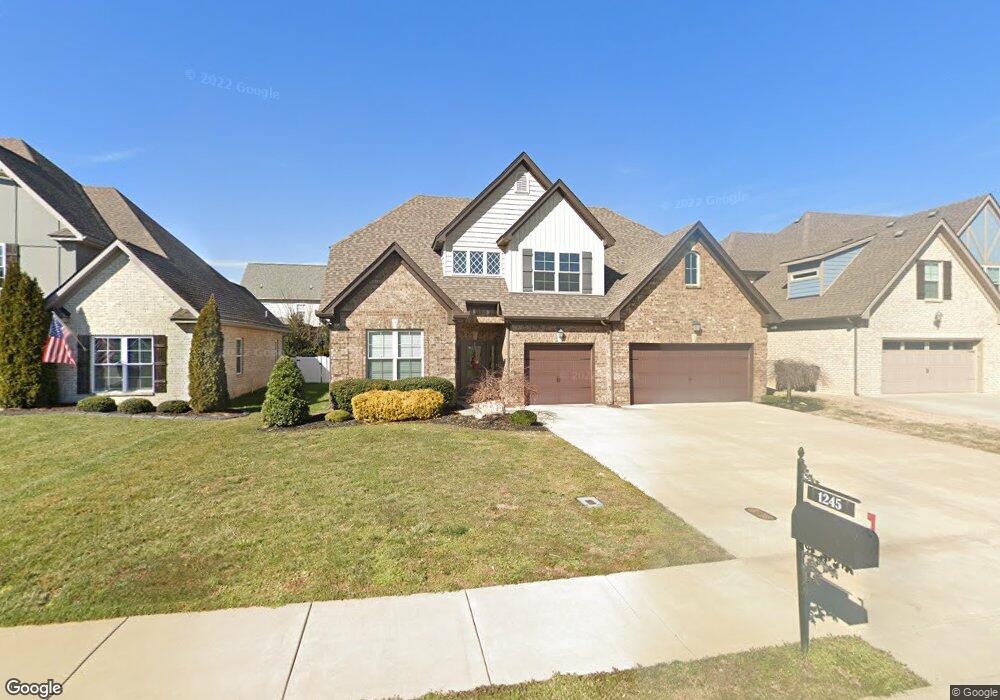
1245 Hensfield Dr Murfreesboro, TN 37128
Estimated Value: $554,670 - $618,000
--
Bed
3
Baths
2,746
Sq Ft
$215/Sq Ft
Est. Value
About This Home
This home is located at 1245 Hensfield Dr, Murfreesboro, TN 37128 and is currently estimated at $589,418, approximately $214 per square foot. 1245 Hensfield Dr is a home located in Rutherford County with nearby schools including Blackman Elementary School, Overall Creek Elementary School, and Blackman Middle School.
Ownership History
Date
Name
Owned For
Owner Type
Purchase Details
Closed on
Feb 19, 2016
Sold by
Harney Homes Llc
Bought by
Garshnick April
Current Estimated Value
Create a Home Valuation Report for This Property
The Home Valuation Report is an in-depth analysis detailing your home's value as well as a comparison with similar homes in the area
Home Values in the Area
Average Home Value in this Area
Purchase History
| Date | Buyer | Sale Price | Title Company |
|---|---|---|---|
| Garshnick April | $327,900 | -- |
Source: Public Records
Tax History Compared to Growth
Tax History
| Year | Tax Paid | Tax Assessment Tax Assessment Total Assessment is a certain percentage of the fair market value that is determined by local assessors to be the total taxable value of land and additions on the property. | Land | Improvement |
|---|---|---|---|---|
| 2025 | $3,278 | $115,850 | $13,750 | $102,100 |
| 2024 | $3,278 | $115,850 | $13,750 | $102,100 |
| 2023 | $2,174 | $115,850 | $13,750 | $102,100 |
| 2022 | $1,872 | $115,850 | $13,750 | $102,100 |
| 2021 | $1,833 | $82,575 | $13,750 | $68,825 |
| 2020 | $1,833 | $82,575 | $13,750 | $68,825 |
| 2019 | $1,833 | $82,575 | $13,750 | $68,825 |
Source: Public Records
Map
Nearby Homes
- 5227 Starnes Dr
- 1232 Stockwell Dr
- 1235 Timber Creek Dr
- 4814 Saint Ives Dr
- 5108 Saint Ives Dr
- 2108 Olmstead Ct
- 629 Brinkley Rd
- 4826 Trevino Ct
- 827 Stovers Glen Dr
- 548 Brinkley Rd
- 814 Stovers Glen
- 5350 Tony Lama Ln
- 5309 Perlou Ln
- 802 Licinius Ln
- 826 Licinius Ln
- 628 Evergreen Dr
- 4670 Forsman Ct
- 5408 Middlebury Dr
- 5313 Eiffel Ct
- 1003 Licinius Ln
- 1245 Hensfield Dr (Lot 222)
- 1249 Hensfield
- 5231 Starnes Dr
- 1237 Hensfield
- 1253 Hensfield Dr
- 5223 Starnes Dr
- 1248 Hensfield Dr Unit 236
- 1248 Hensfield Dr
- 1248 Hensfield Dr (Lot 236)
- 1244 Hensfield Dr
- 5235 Starnes Dr
- 1240 Hensfield
- 1252 Hensfield Dr
- 5219 Starnes Dr
- 1252 Hensfield
- 1233 Hensfield Dr
- 1236 Hensfield Dr
- 1257 Hensfield Dr
- 5239 Starnes Dr
- 1256 Hensfield