Estimated Value: $377,680 - $395,000
3
Beds
2
Baths
1,400
Sq Ft
$274/Sq Ft
Est. Value
About This Home
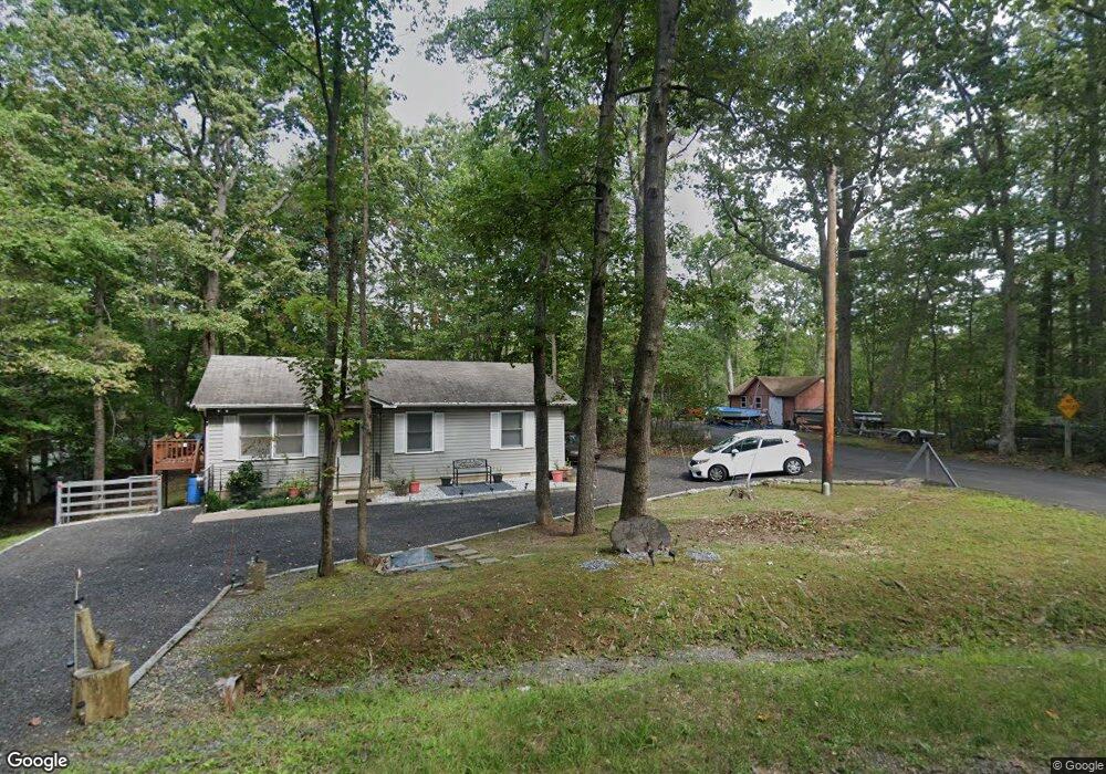
This home is located at 12450 Dalton Ct, Lusby, MD 20657 and is currently estimated at $383,670, approximately $274 per square foot. 12450 Dalton Ct is a home located in Calvert County with nearby schools including Patuxent Appeal Elementary Campus, Mill Creek Middle School, and Patuxent High School.
Ownership History
Date
Name
Owned For
Owner Type
Purchase Details
Closed on
Feb 3, 2009
Sold by
Sibole Paul T and Sibole Julie
Bought by
Farrell Mark A
Current Estimated Value
Purchase Details
Closed on
Sep 3, 2008
Sold by
Sibole Robert Wade
Bought by
Sibole Paul T and Sibole Julie
Purchase Details
Closed on
Aug 22, 2008
Sold by
Sibole Robert Wade
Bought by
Sibole Paul T and Sibole Julie
Purchase Details
Closed on
Aug 13, 2001
Sold by
Hall Thea S
Bought by
Sibole Robert Wade
Create a Home Valuation Report for This Property
The Home Valuation Report is an in-depth analysis detailing your home's value as well as a comparison with similar homes in the area
Home Values in the Area
Average Home Value in this Area
Purchase History
| Date | Buyer | Sale Price | Title Company |
|---|---|---|---|
| Farrell Mark A | $237,500 | -- | |
| Sibole Paul T | -- | -- | |
| Sibole Paul T | -- | -- | |
| Sibole Robert Wade | $115,000 | -- |
Source: Public Records
Mortgage History
| Date | Status | Borrower | Loan Amount |
|---|---|---|---|
| Closed | Farrell Mark A | -- |
Source: Public Records
Tax History
| Year | Tax Paid | Tax Assessment Tax Assessment Total Assessment is a certain percentage of the fair market value that is determined by local assessors to be the total taxable value of land and additions on the property. | Land | Improvement |
|---|---|---|---|---|
| 2025 | $437 | $293,633 | $0 | $0 |
| 2024 | $432 | $271,867 | $0 | $0 |
| 2023 | $154 | $250,100 | $80,700 | $169,400 |
| 2022 | $2,506 | $241,233 | $0 | $0 |
| 2021 | $2,342 | $232,367 | $0 | $0 |
| 2020 | $2,753 | $223,500 | $80,700 | $142,800 |
| 2019 | $2,265 | $215,933 | $0 | $0 |
| 2018 | $2,186 | $208,367 | $0 | $0 |
| 2017 | $2,507 | $200,800 | $0 | $0 |
| 2016 | -- | $200,533 | $0 | $0 |
| 2015 | $3,095 | $200,267 | $0 | $0 |
| 2014 | $3,095 | $200,000 | $0 | $0 |
Source: Public Records
Map
Nearby Homes
- 548 Antelope Trail
- 634 Silver Rock Rd
- 542 Chisholm Trail
- 12361 Silver Rock Cir
- 513 Cody Trail
- 500 Chisholm Trail
- 389 Thunderbird Dr
- 481 Saddle Ct
- 502 Dodge Trail
- 11624 Deadwood Dr
- 504 Thunderbird Dr
- 735 Lazy River Rd
- 11609 Deadwood Dr
- 12509 San Jose Ct
- 12740 Great Ln
- 913 Golden West Way
- 11570 Tomahawk Trail W
- 646 White Rock Rd
- 11722 Big Bear Ln
- 11752 Sidewinder Ln
- 12434 Elk Rd
- 12442 Dalton Trail
- 12430 Elk Rd
- 537 Antelope Trail
- 12462 Dalton Trail
- 540 Antelope Trail
- 544 Antelope Trail
- 552 Antelope Trail
- 12461 Dalton Trail
- 645 Red Rock Trail
- 12431 Elk Rd
- 641 Red Rock Trail
- 649 Red Rock Trail
- 653 Red Rock Trail
- 12467 Dalton Trail
- 569 Platte Rd
- 12418 Red Rock Ct
- 12452 Sedalia Trail
- 565 Platte Rd
- 608 Painted Horse Ct
Your Personal Tour Guide
Ask me questions while you tour the home.