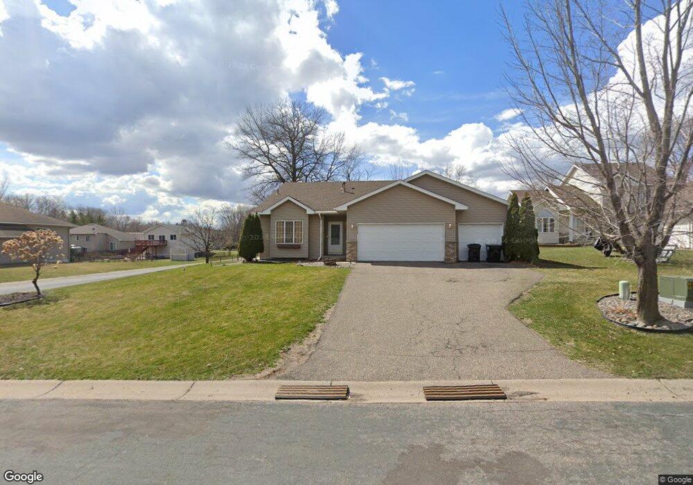
12452 Swallow Cir NW Coon Rapids, MN 55448
Estimated Value: $373,304 - $395,000
3
Beds
2
Baths
1,098
Sq Ft
$353/Sq Ft
Est. Value
About This Home
This home is located at 12452 Swallow Cir NW, Coon Rapids, MN 55448 and is currently estimated at $387,576, approximately $352 per square foot. 12452 Swallow Cir NW is a home located in Anoka County with nearby schools including Lucile Bruner Elementary School, Hoover Elementary School, and Laughlin Junior/Senior High School.
Ownership History
Date
Name
Owned For
Owner Type
Purchase Details
Closed on
Nov 30, 2006
Sold by
Johnson Timothy S and Johnson Kara D
Bought by
Green Ryan and Green Kristin
Current Estimated Value
Home Financials for this Owner
Home Financials are based on the most recent Mortgage that was taken out on this home.
Original Mortgage
$240,500
Outstanding Balance
$143,949
Interest Rate
6.33%
Mortgage Type
New Conventional
Estimated Equity
$243,627
Purchase Details
Closed on
Mar 24, 2000
Sold by
Shade Tree Construction Inc
Bought by
Johnson Timothy S and Johnson Kara D
Create a Home Valuation Report for This Property
The Home Valuation Report is an in-depth analysis detailing your home's value as well as a comparison with similar homes in the area
Home Values in the Area
Average Home Value in this Area
Purchase History
| Date | Buyer | Sale Price | Title Company |
|---|---|---|---|
| Green Ryan | $256,000 | -- | |
| Johnson Timothy S | $151,300 | -- |
Source: Public Records
Mortgage History
| Date | Status | Borrower | Loan Amount |
|---|---|---|---|
| Open | Green Ryan | $240,500 |
Source: Public Records
Tax History Compared to Growth
Tax History
| Year | Tax Paid | Tax Assessment Tax Assessment Total Assessment is a certain percentage of the fair market value that is determined by local assessors to be the total taxable value of land and additions on the property. | Land | Improvement |
|---|---|---|---|---|
| 2025 | $3,851 | $346,500 | $90,300 | $256,200 |
| 2024 | $3,851 | $354,700 | $99,800 | $254,900 |
| 2023 | $4,037 | $346,400 | $86,100 | $260,300 |
| 2022 | $3,124 | $346,400 | $73,500 | $272,900 |
| 2021 | $4,259 | $276,900 | $59,000 | $217,900 |
| 2020 | $3,399 | $270,900 | $63,000 | $207,900 |
| 2019 | $3,551 | $268,500 | $67,000 | $201,500 |
| 2018 | $2,897 | $243,500 | $0 | $0 |
| 2017 | $2,626 | $223,800 | $0 | $0 |
| 2016 | $2,659 | $195,900 | $0 | $0 |
| 2015 | $2,913 | $195,900 | $51,000 | $144,900 |
| 2014 | -- | $177,400 | $50,300 | $127,100 |
Source: Public Records
Map
Nearby Homes
- 2147 125th Ln NW
- 2068 124th Ln NW
- 12760 Raven St NW
- 2675 128th Ave NW
- 1930 127th Cir NW
- 12365 Jay St NW
- 12888 Nightingale St NW
- 12019 Zion St NW
- 1727 121st Ln NW
- 12554 Grouse St NW
- 12759 Ibis St NW
- 1593 126th Ln NW
- 12463 Drake St NW
- 11749 Crooked Lake Blvd NW
- 13182 Zion St NW
- 1450 126th Ln NW
- 12010 Eagle St NW
- 3074 121st Ave NW
- 1520 129th Ave NW
- 13416 Swallow St NW
- 12466 Swallow Cir NW
- 12436 Swallow Cir NW
- 12451 Thrush St NW
- 12467 Thrush St NW
- 12455 Swallow Cir NW
- 12471 Swallow Cir NW
- 12425 Thrush St NW
- 12439 Swallow Cir NW
- 12422 Swallow Cir NW
- 12477 Swallow Cir NW
- 12489 Thrush St NW
- xxx Swallow Cir NW
- 12413 Thrush St NW
- 12425 Swallow Cir NW
- 12408 Swallow Cir NW
- 12450 Raven St NW
- 12464 Raven St NW
- 12436 Raven St NW
- 12411 Swallow Cir NW
- 12432 Thrush St NW