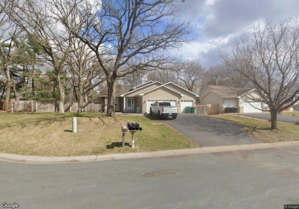
12457 Quinn St NW Coon Rapids, MN 55448
Estimated Value: $369,545 - $388,000
3
Beds
2
Baths
1,000
Sq Ft
$382/Sq Ft
Est. Value
About This Home
This home is located at 12457 Quinn St NW, Coon Rapids, MN 55448 and is currently estimated at $382,386, approximately $382 per square foot. 12457 Quinn St NW is a home located in Anoka County with nearby schools including Lucile Bruner Elementary School, Hoover Elementary School, and Laughlin Junior/Senior High School.
Ownership History
Date
Name
Owned For
Owner Type
Purchase Details
Closed on
Mar 25, 2010
Sold by
Fnma
Bought by
Douglas Brian M and Douglas Michelle A
Current Estimated Value
Home Financials for this Owner
Home Financials are based on the most recent Mortgage that was taken out on this home.
Original Mortgage
$174,775
Outstanding Balance
$116,645
Interest Rate
5.12%
Estimated Equity
$265,741
Purchase Details
Closed on
Mar 31, 2000
Sold by
Shade Tree Construction Inc
Bought by
Kanduth Sherri N and Kanduth Robbie J
Create a Home Valuation Report for This Property
The Home Valuation Report is an in-depth analysis detailing your home's value as well as a comparison with similar homes in the area
Home Values in the Area
Average Home Value in this Area
Purchase History
| Date | Buyer | Sale Price | Title Company |
|---|---|---|---|
| Douglas Brian M | $178,000 | -- | |
| Kanduth Sherri N | $152,265 | -- |
Source: Public Records
Mortgage History
| Date | Status | Borrower | Loan Amount |
|---|---|---|---|
| Open | Douglas Brian M | $174,775 |
Source: Public Records
Tax History Compared to Growth
Tax History
| Year | Tax Paid | Tax Assessment Tax Assessment Total Assessment is a certain percentage of the fair market value that is determined by local assessors to be the total taxable value of land and additions on the property. | Land | Improvement |
|---|---|---|---|---|
| 2025 | $3,840 | $334,300 | $90,300 | $244,000 |
| 2024 | $3,840 | $342,500 | $99,800 | $242,700 |
| 2023 | $3,256 | $335,300 | $86,100 | $249,200 |
| 2022 | $2,970 | $333,300 | $73,500 | $259,800 |
| 2021 | $2,953 | $273,200 | $62,000 | $211,200 |
| 2020 | $3,091 | $265,600 | $66,200 | $199,400 |
| 2019 | $2,897 | $266,000 | $70,400 | $195,600 |
| 2018 | $2,768 | $243,800 | $0 | $0 |
| 2017 | $2,320 | $227,200 | $0 | $0 |
| 2016 | $2,342 | $189,200 | $0 | $0 |
| 2015 | -- | $189,200 | $53,600 | $135,600 |
| 2014 | -- | $173,700 | $52,800 | $120,900 |
Source: Public Records
Map
Nearby Homes
- 2068 124th Ln NW
- 2147 125th Ln NW
- 12760 Raven St NW
- 1930 127th Cir NW
- 12365 Jay St NW
- 12888 Nightingale St NW
- 1727 121st Ln NW
- 12554 Grouse St NW
- 2675 128th Ave NW
- 12759 Ibis St NW
- 1593 126th Ln NW
- 12463 Drake St NW
- 12019 Zion St NW
- 1450 126th Ln NW
- 12010 Eagle St NW
- 1520 129th Ave NW
- 1687 131st Ln NW
- 1449 119th Ln NW
- 13182 Zion St NW
- 11749 Crooked Lake Blvd NW
- 12443 Quinn St NW
- 12481 Quinn St NW
- 12434 Partridge St NW
- 12429 Quinn St NW
- 2132 Main St NW
- 12420 Partridge St NW
- 2132 Main-Street-nw
- 12471 Quinn St NW
- 12454 Quinn St NW
- 12416 Partridge St NW
- 12415 Quinn St NW
- 12426 Quinn St NW
- 12468 Quinn St NW
- 12448 Partridge St NW
- 12410 Partridge St NW
- 12486 Partridge St NW
- 12482 Quinn St NW
- 12412 Quinn St NW
- 12441 Raven St NW
- 12431 Partridge St NW