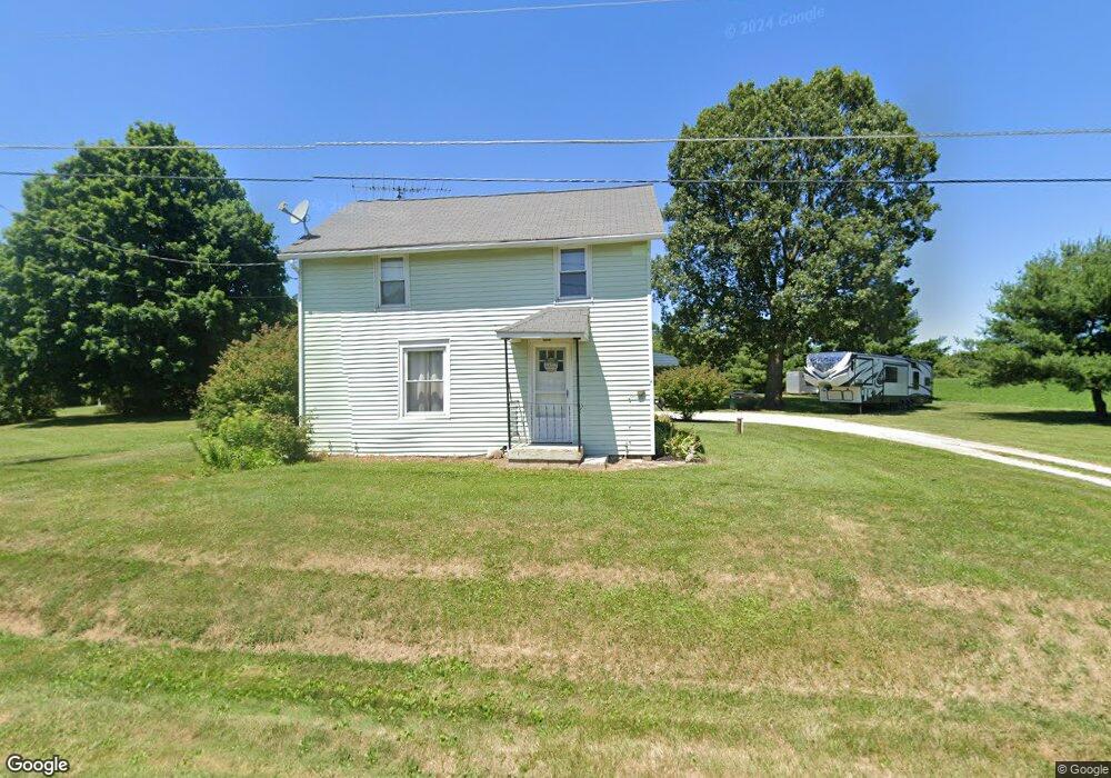
1246 State Route 96 Ashland, OH 44805
Estimated Value: $184,269 - $261,000
2
Beds
2
Baths
1,186
Sq Ft
$176/Sq Ft
Est. Value
About This Home
This home is located at 1246 State Route 96, Ashland, OH 44805 and is currently estimated at $209,317, approximately $176 per square foot. 1246 State Route 96 is a home located in Ashland County with nearby schools including Ashland High School, Ashland County Community Academy, and Ashland Christian Elementary School.
Ownership History
Date
Name
Owned For
Owner Type
Purchase Details
Closed on
Oct 20, 2011
Sold by
Braden Clayton P
Bought by
Crone Steven M and Crone Linda K
Current Estimated Value
Home Financials for this Owner
Home Financials are based on the most recent Mortgage that was taken out on this home.
Original Mortgage
$54,750
Outstanding Balance
$21,614
Interest Rate
4.12%
Mortgage Type
New Conventional
Estimated Equity
$187,703
Purchase Details
Closed on
Jun 27, 2005
Sold by
Braden Clayton P
Bought by
Crone Jeremy J
Purchase Details
Closed on
Dec 30, 1996
Bought by
Braden Clayton P
Create a Home Valuation Report for This Property
The Home Valuation Report is an in-depth analysis detailing your home's value as well as a comparison with similar homes in the area
Home Values in the Area
Average Home Value in this Area
Purchase History
| Date | Buyer | Sale Price | Title Company |
|---|---|---|---|
| Crone Steven M | $73,000 | -- | |
| Crone Jeremy J | $92,500 | -- | |
| Braden Clayton P | $71,000 | -- |
Source: Public Records
Mortgage History
| Date | Status | Borrower | Loan Amount |
|---|---|---|---|
| Open | Crone Steven M | $54,750 |
Source: Public Records
Tax History Compared to Growth
Tax History
| Year | Tax Paid | Tax Assessment Tax Assessment Total Assessment is a certain percentage of the fair market value that is determined by local assessors to be the total taxable value of land and additions on the property. | Land | Improvement |
|---|---|---|---|---|
| 2024 | $1,551 | $40,890 | $10,590 | $30,300 |
| 2023 | $1,551 | $40,890 | $10,590 | $30,300 |
| 2022 | $1,522 | $31,450 | $8,140 | $23,310 |
| 2021 | $1,527 | $31,450 | $8,140 | $23,310 |
| 2020 | $1,454 | $31,450 | $8,140 | $23,310 |
| 2019 | $1,517 | $30,370 | $7,700 | $22,670 |
| 2018 | $1,539 | $30,710 | $8,040 | $22,670 |
| 2017 | $1,414 | $30,710 | $8,040 | $22,670 |
| 2016 | $1,414 | $27,180 | $7,120 | $20,060 |
| 2015 | $1,403 | $27,180 | $7,120 | $20,060 |
| 2013 | $1,541 | $29,230 | $7,280 | $21,950 |
Source: Public Records
Map
Nearby Homes
- 1202 County Road 1356
- 905 Ridge Rd
- 1136 Overlook Dr
- 1170 Township Road 1426
- 1439 Township Road 1238
- 702 Sandusky St
- 1537 Short St
- 0 Westlake Dr
- 1440 Township Road 1106
- 410 Ohio St
- 1115 Cottage St
- 323 W 4th St
- 325 W 4th St
- 427 W Main St
- 101 W 12th St
- 1026 Claremont Ave
- 1191 State Route 511
- 1471 Troy Rd
- 827 Orange St
- 33 E 8th St
- 1246 Ohio 96
- 1236 State Route 96
- 1253 State Route 96
- 1253 State Route 96
- 1253 State Route 96
- 1253 Ohio 96
- 1254 State Route 96
- 1239 Township Road 1253
- 1220 1253
- 1220 Township Road 1253
- 1255 State Route 96
- 1240 Township Road 1253
- 1217 Township Road 1253
- 1257 Ohio 96
- 1257 State Route 96
- 1257 State Route 96
- 1258 State Route 96
- 1218 Township Road 1253
- 1230 State Route 96
- 1229 State Route 96