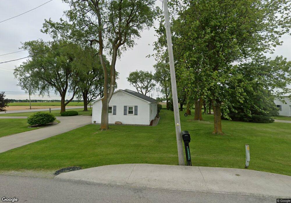
12470 Road 162 Paulding, OH 45879
Estimated Value: $150,000 - $178,000
2
Beds
2
Baths
1,272
Sq Ft
$127/Sq Ft
Est. Value
About This Home
This home is located at 12470 Road 162, Paulding, OH 45879 and is currently estimated at $161,471, approximately $126 per square foot. 12470 Road 162 is a home located in Paulding County with nearby schools including Paulding High School.
Ownership History
Date
Name
Owned For
Owner Type
Purchase Details
Closed on
Dec 21, 2024
Sold by
Raydot Llc
Bought by
Goyings Stephen R
Current Estimated Value
Purchase Details
Closed on
Dec 22, 2021
Sold by
Goyings Ray S
Bought by
Raydot Llc
Home Financials for this Owner
Home Financials are based on the most recent Mortgage that was taken out on this home.
Original Mortgage
$66,838
Interest Rate
3.43%
Mortgage Type
New Conventional
Purchase Details
Closed on
Apr 26, 1999
Sold by
Goyings Ray S
Bought by
Goyings Ray S Trustee Goyings Dorothy I
Create a Home Valuation Report for This Property
The Home Valuation Report is an in-depth analysis detailing your home's value as well as a comparison with similar homes in the area
Home Values in the Area
Average Home Value in this Area
Purchase History
We collect this data history from publicly available records. To have your information removed, we recommend requesting removal directly through your county’s website.
| Date | Buyer | Sale Price | Title Company |
|---|---|---|---|
| Goyings Stephen R | -- | None Listed On Document | |
| Goyings Stephen R | -- | None Listed On Document | |
| Raydot Llc | -- | None Available | |
| Goyings Ray S | -- | None Available | |
| Goyings Ray | -- | None Listed On Document | |
| Goyings Ray S Trustee Goyings Dorothy I | -- | -- |
Source: Public Records
Mortgage History
We collect this data history from publicly available records. To have your information removed, we recommend requesting removal directly through your county’s website.
| Date | Status | Borrower | Loan Amount |
|---|---|---|---|
| Previous Owner | Goyings Ray | $66,838 | |
| Closed | Raydot Llc | $0 |
Source: Public Records
Tax History
| Year | Tax Paid | Tax Assessment Tax Assessment Total Assessment is a certain percentage of the fair market value that is determined by local assessors to be the total taxable value of land and additions on the property. | Land | Improvement |
|---|---|---|---|---|
| 2025 | $1,686 | $49,530 | $10,570 | $38,960 |
| 2024 | $1,686 | $34,340 | $7,000 | $27,340 |
| 2023 | $867 | $34,340 | $7,000 | $27,340 |
| 2022 | $898 | $34,340 | $7,000 | $27,340 |
| 2021 | $651 | $26,530 | $7,000 | $19,530 |
| 2020 | $673 | $26,530 | $7,000 | $19,530 |
| 2019 | $679 | $24,750 | $7,000 | $17,750 |
| 2018 | $617 | $24,750 | $7,000 | $17,750 |
| 2017 | $617 | $24,750 | $7,000 | $17,750 |
| 2016 | $617 | $24,750 | $7,000 | $17,750 |
| 2015 | $714 | $27,480 | $7,000 | $20,480 |
| 2014 | $710 | $27,480 | $7,000 | $20,480 |
| 2013 | $783 | $27,480 | $7,000 | $20,480 |
Source: Public Records
Map
Nearby Homes
- 12035 Royer Ave
- 1157 Emerald Rd
- 13502 Rita St
- 809 Country View Dr
- 830 N Walnut St
- 13795 Nancy St
- 713 N Walnut St
- 516 N Williams St
- 301 N Main St
- 215 N Dewitt St
- 780 W Jackson St
- 714 W Wayne St
- 111 W Wayne St
- 181 Bittersweet Dr
- 335 S Williams St
- 742 E Perry St
- 11051 Road 93
- 9881 Road 180
- 9266 Road 107
- 9781 Road 192
- 13174 Us Route 127
- 12705 Road 162
- 13200 Us Route 127
- 12737 Road 162
- 12152 Road 162
- 12571 Us Route 127
- 13522 Us Route 127
- 601 Airport Rd
- 13507 Us Route 127
- 11902 Road 162
- 609 Airport Rd
- 611 Airport Rd
- 617 Airport Rd
- 623 Airport Rd
- 635 Airport Rd
- 1250 N Williams St
- 12155 Royer Ave
- 12335 Royer Ave
- 12531 Royer Ave
- 1110 N Williams St
Your Personal Tour Guide
Ask me questions while you tour the home.