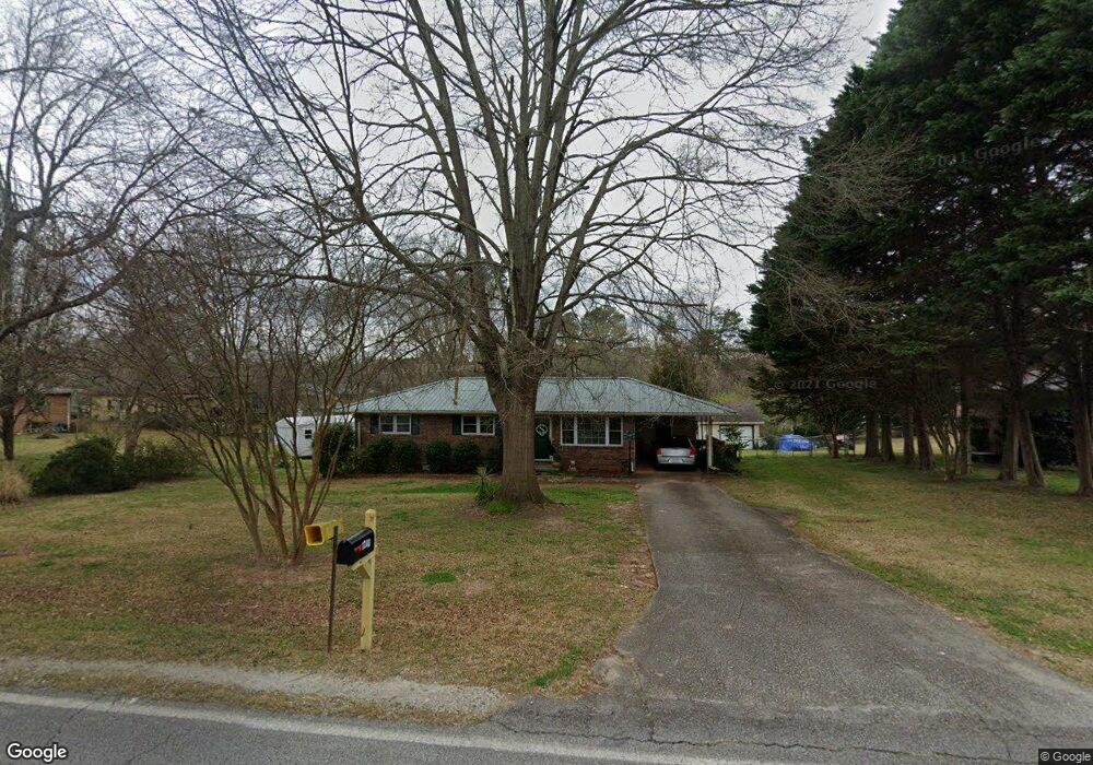
1248 Skyline Dr Toccoa, GA 30577
Estimated Value: $234,000 - $267,000
4
Beds
2
Baths
1,740
Sq Ft
$142/Sq Ft
Est. Value
About This Home
This home is located at 1248 Skyline Dr, Toccoa, GA 30577 and is currently estimated at $246,910, approximately $141 per square foot. 1248 Skyline Dr is a home located in Stephens County with nearby schools including Stephens County High School.
Ownership History
Date
Name
Owned For
Owner Type
Purchase Details
Closed on
Aug 27, 2014
Sold by
Smith Phyllis C
Bought by
Smith Phyllis C and Beck Amy Davis
Current Estimated Value
Purchase Details
Closed on
Aug 14, 2014
Sold by
Sosby Stephen R
Bought by
Smith Phyllis C
Purchase Details
Closed on
Apr 18, 2014
Sold by
Sosby Stephen R
Bought by
Smith Phyllis C
Purchase Details
Closed on
Jul 1, 1997
Bought by
<Buyer Info Not Present>
Create a Home Valuation Report for This Property
The Home Valuation Report is an in-depth analysis detailing your home's value as well as a comparison with similar homes in the area
Purchase History
| Date | Buyer | Sale Price | Title Company |
|---|---|---|---|
| Smith Phyllis C | -- | -- | |
| Smith Phyllis C | -- | -- | |
| Smith Phyllis C | -- | -- | |
| <Buyer Info Not Present> | -- | -- |
Source: Public Records
Tax History
| Year | Tax Paid | Tax Assessment Tax Assessment Total Assessment is a certain percentage of the fair market value that is determined by local assessors to be the total taxable value of land and additions on the property. | Land | Improvement |
|---|---|---|---|---|
| 2025 | $3,074 | $88,092 | $2,268 | $85,824 |
| 2024 | $2,108 | $59,121 | $2,268 | $56,853 |
| 2023 | $1,947 | $55,045 | $2,268 | $52,777 |
| 2022 | $1,548 | $51,989 | $2,268 | $49,721 |
| 2021 | $1,497 | $47,882 | $2,268 | $45,614 |
| 2020 | $1,510 | $47,802 | $2,268 | $45,534 |
| 2019 | $1,077 | $33,955 | $2,268 | $31,687 |
| 2018 | $1,071 | $33,786 | $2,268 | $31,518 |
| 2017 | $1,086 | $33,702 | $2,268 | $31,434 |
| 2016 | $1,069 | $33,702 | $2,268 | $31,434 |
| 2015 | $1,097 | $33,025 | $2,268 | $30,757 |
| 2014 | $1,115 | $33,026 | $2,268 | $30,757 |
| 2013 | -- | $33,732 | $2,268 | $31,464 |
Source: Public Records
Map
Nearby Homes
- 158 Pebble Creek Dr
- 475 Hilltop Way
- 1055 Skyline Dr
- 820 Collier Rd
- 208 Cherry St
- 926 Skyline Dr
- 372 Hilltop Way
- 321 Quail Forest Cir
- 43 Sycamore Dr
- 74 Briarwood Dr
- 39 Meadowbrook Dr
- 207 Poplar Trail
- 704 Skyline Dr
- 103 Old Liberty Hill Rd
- 156 White Pine Rd
- 526 Poplar St
- 1010 Mize Rd
- 0 Valley Dr Unit 10701357
- 0 Stephen Dr Unit 10710969
- 0 Stephen Dr Unit 10710891
- 1226 Skyline Dr
- 551 Andrews Rd
- 535 Andrews Rd
- 689 Hilltop Way
- 655 Hilltop Way
- 1208 Skyline Dr
- 1255 Skyline Dr
- 1241 Skyline Dr
- 0 Anderson Rd Unit 7626611
- 517 Andrews Rd
- 647 Hilltop Way
- 490 Tahoe Trail
- 370 Trudy Trail
- 00 Seraph Point
- 15 Julia Ct
- 1221 Skyline Dr
- 1196 Skyline Dr
- 554 Andrews Rd
- 1197 Skyline Dr
- 536 Andrews Rd
Your Personal Tour Guide
Ask me questions while you tour the home.