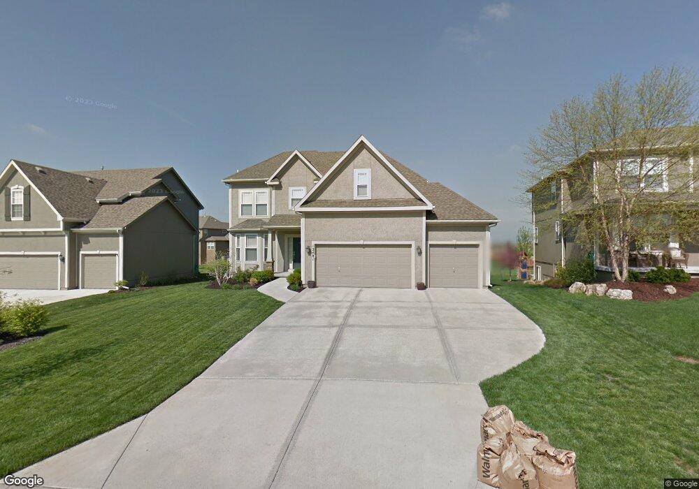
12481 S Kenton St Olathe, KS 66061
Estimated Value: $545,000 - $686,000
4
Beds
4
Baths
2,471
Sq Ft
$250/Sq Ft
Est. Value
About This Home
This home is located at 12481 S Kenton St, Olathe, KS 66061 and is currently estimated at $618,138, approximately $250 per square foot. 12481 S Kenton St is a home located in Johnson County with nearby schools including Forest View Elementary School, Mission Trail Middle School, and Olathe West High School.
Ownership History
Date
Name
Owned For
Owner Type
Purchase Details
Closed on
Jan 2, 2018
Sold by
Sherry Scott R and Fisher Sherry Sherri A
Bought by
Sherry Scott R and Fisher Sherry Sherri A
Current Estimated Value
Purchase Details
Closed on
Mar 7, 2008
Sold by
Rodrock Homes At Forest View Llc
Bought by
Fisher Sherry Scott R and Fisher Sherry Sherri
Home Financials for this Owner
Home Financials are based on the most recent Mortgage that was taken out on this home.
Original Mortgage
$253,600
Interest Rate
6.11%
Mortgage Type
New Conventional
Purchase Details
Closed on
Nov 1, 2007
Sold by
119 7 Roadside Partners Llc
Bought by
Rodrock Homes At Forest View Llc
Create a Home Valuation Report for This Property
The Home Valuation Report is an in-depth analysis detailing your home's value as well as a comparison with similar homes in the area
Home Values in the Area
Average Home Value in this Area
Purchase History
| Date | Buyer | Sale Price | Title Company |
|---|---|---|---|
| Sherry Scott R | -- | None Available | |
| Fisher Sherry Scott R | -- | First American Title Ins Co | |
| Rodrock Homes At Forest View Llc | -- | First American Title Ins Co |
Source: Public Records
Mortgage History
| Date | Status | Borrower | Loan Amount |
|---|---|---|---|
| Previous Owner | Fisher Sherry Scott R | $253,600 |
Source: Public Records
Tax History Compared to Growth
Tax History
| Year | Tax Paid | Tax Assessment Tax Assessment Total Assessment is a certain percentage of the fair market value that is determined by local assessors to be the total taxable value of land and additions on the property. | Land | Improvement |
|---|---|---|---|---|
| 2024 | $7,162 | $62,986 | $12,279 | $50,707 |
| 2023 | $6,972 | $60,410 | $11,168 | $49,242 |
| 2022 | $6,338 | $53,440 | $9,707 | $43,733 |
| 2021 | $6,338 | $47,920 | $9,707 | $38,213 |
| 2020 | $5,913 | $47,230 | $9,707 | $37,523 |
| 2019 | $5,778 | $45,850 | $8,091 | $37,759 |
| 2018 | $5,513 | $43,447 | $8,093 | $35,354 |
| 2017 | $5,580 | $43,505 | $7,803 | $35,702 |
| 2016 | $5,428 | $42,148 | $7,803 | $34,345 |
| 2015 | $5,142 | $39,848 | $7,803 | $32,045 |
| 2013 | -- | $33,810 | $7,006 | $26,804 |
Source: Public Records
Map
Nearby Homes
- 23444 W 125th St
- 12519 S Mesquite St
- 23659 W 125th Terrace
- Zachary Plan at Arbor Woods
- Xavier Plan at Arbor Woods
- Sutton Plan at Arbor Woods
- Thaddeus Plan at Arbor Woods
- Scorpio Plan at Arbor Woods
- Porter Plan at Arbor Woods
- Olivia Plan at Arbor Woods
- Noah Plan at Arbor Woods
- Mateo Plan at Arbor Woods
- Nicholas Plan at Arbor Woods
- Nadia Plan at Arbor Woods
- Matthew Plan at Arbor Woods
- Marius Plan at Arbor Woods
- Madeline Plan at Arbor Woods
- Lucas Plan at Arbor Woods
- Louis Plan at Arbor Woods
- Liam Plan at Arbor Woods
- 12475 S Kenton St
- 12487 S Kenton St
- 12493 S Kenton St
- 12469 S Kenton St
- 12484 S Kenton St
- 12476 S Kenton St
- 12480 S Dunraven St
- 12467 S Dunraven St
- 23520 W 125th St
- 12463 S Kenton St
- 12470 S Kenton St
- 12468 S Dunraven St
- 12464 S Kenton St
- 23488 W 125th St
- 23662 W 125th St
- 12476 S Solomon Rd
- 12456 S Dunraven St
- 23466 W 125th St
- 23684 W 125th St
- 12435 S Dunraven St