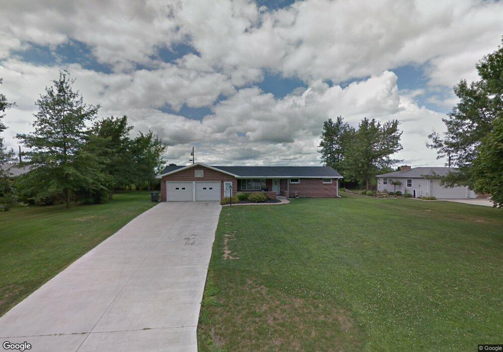
12487 Maple Ave Paulding, OH 45879
Estimated Value: $179,000 - $223,000
3
Beds
2
Baths
1,431
Sq Ft
$137/Sq Ft
Est. Value
About This Home
This home is located at 12487 Maple Ave, Paulding, OH 45879 and is currently estimated at $196,120, approximately $137 per square foot. 12487 Maple Ave is a home located in Paulding County with nearby schools including Paulding High School.
Ownership History
Date
Name
Owned For
Owner Type
Purchase Details
Closed on
Sep 16, 2010
Sold by
Follas Debra and Follas Evan
Bought by
Porter Patricia S
Current Estimated Value
Home Financials for this Owner
Home Financials are based on the most recent Mortgage that was taken out on this home.
Original Mortgage
$77,000
Outstanding Balance
$49,992
Interest Rate
4.42%
Mortgage Type
New Conventional
Estimated Equity
$146,128
Purchase Details
Closed on
Dec 29, 2009
Sold by
Sloop Mary Kay
Bought by
Follas Debra and Sloop Donald
Create a Home Valuation Report for This Property
The Home Valuation Report is an in-depth analysis detailing your home's value as well as a comparison with similar homes in the area
Home Values in the Area
Average Home Value in this Area
Purchase History
| Date | Buyer | Sale Price | Title Company |
|---|---|---|---|
| Porter Patricia S | $129,000 | None Available | |
| Follas Debra | -- | None Available |
Source: Public Records
Mortgage History
| Date | Status | Borrower | Loan Amount |
|---|---|---|---|
| Open | Porter Patricia S | $77,000 |
Source: Public Records
Tax History
| Year | Tax Paid | Tax Assessment Tax Assessment Total Assessment is a certain percentage of the fair market value that is determined by local assessors to be the total taxable value of land and additions on the property. | Land | Improvement |
|---|---|---|---|---|
| 2025 | $2,532 | $58,490 | $13,650 | $44,840 |
| 2024 | $2,532 | $44,980 | $10,500 | $34,480 |
| 2023 | $2,023 | $44,980 | $10,500 | $34,480 |
| 2022 | $1,976 | $44,980 | $10,500 | $34,480 |
| 2021 | $1,717 | $34,970 | $7,880 | $27,090 |
| 2020 | $1,541 | $34,970 | $7,880 | $27,090 |
| 2019 | $1,553 | $32,520 | $7,880 | $24,640 |
| 2018 | $1,466 | $32,520 | $7,880 | $24,640 |
| 2017 | $1,468 | $32,520 | $7,880 | $24,640 |
| 2016 | $1,473 | $32,520 | $7,880 | $24,640 |
| 2015 | $1,305 | $29,230 | $7,880 | $21,350 |
| 2014 | $1,298 | $29,230 | $7,880 | $21,350 |
| 2013 | $1,399 | $29,230 | $7,880 | $21,350 |
Source: Public Records
Map
Nearby Homes
- 830 N Walnut St
- 1118 Emerald Rd
- 713 N Walnut St
- 741 Tom Tim Dr
- 516 N Williams St
- 406 N Cherry St
- 13688 Kay St
- 301 N Main St
- 215 N Dewitt St
- 780 W Jackson St
- 111 W Wayne St
- 520 W Wayne St
- 717 W Harrison St
- 714 W Wayne St
- 701 E Wayne St
- 200 German St
- 742 E Perry St
- 11051 Road 93
- 15010 U S 127
- 225 2nd St
- 12415 Maple Ave
- 12532 Maple Ave
- 12547 Maple Ave
- 12464 Maple Ave
- 12438 Maple Ave
- 12353 Maple Ave
- 12605 Maple Ave
- 12582 Maple Ave
- 12388 Maple Ave
- 12642 Maple Ave
- 12320 Maple Ave
- 12281 Maple Ave
- 12673 Maple Ave
- 1048 N Williams St
- 1036 N Williams St
- 1052 N Williams St
- 1028 N Williams St
- 1070 N Williams St
- 12702 Maple Ave
- 12221 Maple Ave
Your Personal Tour Guide
Ask me questions while you tour the home.