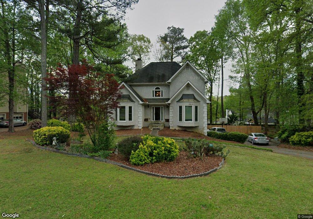
1249 Wynford Colony SW Unit 1 Marietta, GA 30064
West Cobb NeighborhoodEstimated Value: $458,000 - $493,000
4
Beds
4
Baths
2,324
Sq Ft
$205/Sq Ft
Est. Value
About This Home
This home is located at 1249 Wynford Colony SW Unit 1, Marietta, GA 30064 and is currently estimated at $477,234, approximately $205 per square foot. 1249 Wynford Colony SW Unit 1 is a home located in Cobb County with nearby schools including Dowell Elementary School, Lovinggood Middle School, and Hillgrove High School.
Ownership History
Date
Name
Owned For
Owner Type
Purchase Details
Closed on
Jun 19, 2018
Sold by
Davis Mitchell
Bought by
Davis Cynthia C
Current Estimated Value
Purchase Details
Closed on
Oct 30, 2009
Sold by
Davis Cynthia
Bought by
Davis Mitchell and Davis Cytnhia
Purchase Details
Closed on
Mar 31, 1994
Sold by
Stricklin Dennis W Sandra
Bought by
Kenner Dan Julia A
Home Financials for this Owner
Home Financials are based on the most recent Mortgage that was taken out on this home.
Original Mortgage
$135,000
Interest Rate
7.26%
Purchase Details
Closed on
Apr 14, 1993
Sold by
Brassell Warren A
Bought by
Stricklin Dennis W Sandra
Home Financials for this Owner
Home Financials are based on the most recent Mortgage that was taken out on this home.
Original Mortgage
$137,750
Interest Rate
7.39%
Create a Home Valuation Report for This Property
The Home Valuation Report is an in-depth analysis detailing your home's value as well as a comparison with similar homes in the area
Home Values in the Area
Average Home Value in this Area
Purchase History
| Date | Buyer | Sale Price | Title Company |
|---|---|---|---|
| Davis Cynthia C | -- | -- | |
| Davis Mitchell | -- | -- | |
| Kenner Dan Julia A | $150,000 | -- | |
| Stricklin Dennis W Sandra | $145,000 | -- |
Source: Public Records
Mortgage History
| Date | Status | Borrower | Loan Amount |
|---|---|---|---|
| Previous Owner | Kenner Dan Julia A | $135,000 | |
| Previous Owner | Stricklin Dennis W Sandra | $137,750 |
Source: Public Records
Tax History Compared to Growth
Tax History
| Year | Tax Paid | Tax Assessment Tax Assessment Total Assessment is a certain percentage of the fair market value that is determined by local assessors to be the total taxable value of land and additions on the property. | Land | Improvement |
|---|---|---|---|---|
| 2024 | $990 | $182,532 | $34,000 | $148,532 |
| 2023 | $761 | $174,724 | $34,000 | $140,724 |
| 2022 | $3,134 | $131,476 | $26,000 | $105,476 |
| 2021 | $2,861 | $119,004 | $21,600 | $97,404 |
| 2020 | $2,541 | $104,420 | $21,600 | $82,820 |
| 2019 | $2,541 | $104,420 | $21,600 | $82,820 |
| 2018 | $2,541 | $104,420 | $21,600 | $82,820 |
| 2017 | $2,176 | $91,404 | $21,600 | $69,804 |
| 2016 | $2,180 | $91,404 | $21,600 | $69,804 |
| 2015 | $1,963 | $79,596 | $21,660 | $57,936 |
| 2014 | $1,978 | $79,596 | $0 | $0 |
Source: Public Records
Map
Nearby Homes
- 1234 Wynford Colony SW
- 3006 Coffman Ct SW
- 1518 Sage Ridge Dr
- 2866 Wynford Dr SW Unit 2
- 1567 Vine Leaf Dr
- 1237 Wynford Woods SW
- 1765 Dew Place
- 3001 Ashland Ct SW
- 1209 Wilkes Way SW Unit 1
- 3416 N Cook Rd
- 3354 Hannah Ct
- 2673 Altony Dr SW
- 1204 Commonwealth Ave SW
- 1311 Bustling Ln SW
- 1313 Bustling Ln SW
- 1884 Dovonshire Rd SW
- 2418 Southern Oak Dr SW
- 1004 Villa Rica Rd SW
- 1853 Edington Rd SW
- 1247 Wynford Colony SW
- 1251 Wynford Colony SW
- 1624 Ashmar Ln SW
- 1626 Ashmar Ln SW
- 1245 Wynford Colony SW
- 1248 Wynford Colony SW Unit 1
- 1253 Wynford Colony SW
- 1250 Wynford Colony SW
- 1246 Wynford Colony SW Unit 1
- 1554 Sage Ridge Unit 8
- 1625 Ashmar Ln SW
- 1252 Wynford Colony SW
- 1628 Ashmar Ln SW
- 1243 Wynford Colony SW
- 1244 Wynford Colony SW Unit I
- 1255 Wynford Colony SW
- 1550 Sage Ridge Dr
- 1627 Ashmar Ln SW
- 1254 Wynford Colony SW Unit 1
- 2718 Wynford Ave SW