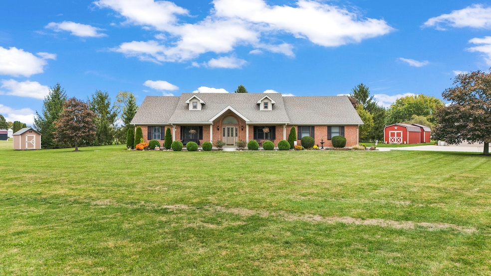
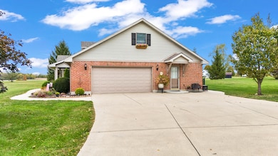
12490 Stafford Rd New Carlisle, OH 45344
Estimated payment $3,883/month
Highlights
- Deck
- Cathedral Ceiling
- Walk-In Pantry
- 1.5-Story Property
- No HOA
- Separate Outdoor Workshop
About This Home
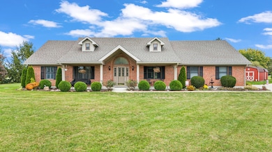
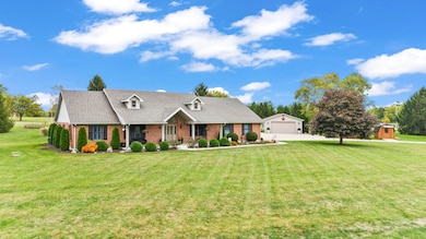
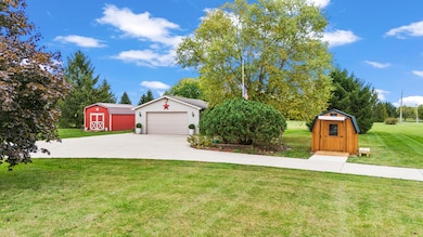
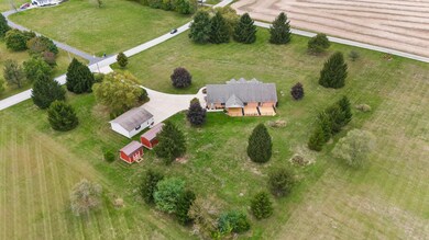
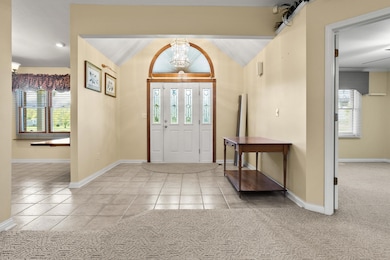
Welcome to this beautifully maintained 4 bedroom, 3 full bath home, situated on 2.5 picturesque acres with two outbuildings, a detached garage, and two sheds, offering 2,075 sq. ft. of comfortable living space. Built in 1996, this property blends quality craftsmanship with modern updates throughout. The kitchen features soft-close cherry cabinets, a large walk-in pantry, and a new refrigerator installed in June 2025--perfect for the home chef. Each custom-designed bathroom is wheelchair accessible, offering both style and functionality. The home also features a very spacious bedroom above the garage, perfect for guests, a home office, or a private retreat. Enjoy cozy evenings by the propane fireplace with blower, and take advantage of the included TVs, which will convey with the home. Additional highlights include a 50-gallon propane water heater, newer garage doors, and outdoor lighting surrounding the property for enhanced curb appeal and security. Step outside to a massive back deck, replaced in 2024 and stained in 2025, featuring solar lights on each post, with low-maintenance aluminum construction. Both the attached and detached garages are heated, with the detached garage including an installed air compressor and built-in shelving for storage. The attached garage has an additional refrigerator and freezer. All windows and doors are premium Andersen, and the roof was replaced in 2015. The HVAC system (air conditioner and heat pump) was installed in 2022 for year-round comfort. The propane tank is underground for eye appeal. A new front porch swing completes the inviting exterior--perfect for relaxing evenings in this well-cared-for home.
Home Details
Home Type
- Single Family
Est. Annual Taxes
- $5,400
Year Built
- Built in 1996
Lot Details
- 2.55 Acre Lot
Parking
- 4 Car Garage
Home Design
- 1.5-Story Property
- Brick Exterior Construction
- Slab Foundation
Interior Spaces
- 2,075 Sq Ft Home
- Cathedral Ceiling
- Ceiling Fan
- Fireplace
- French Doors
Kitchen
- Walk-In Pantry
- Built-In Electric Oven
- Cooktop
- Microwave
Bedrooms and Bathrooms
- 4 Bedrooms
- Walk-In Closet
- 3 Full Bathrooms
Laundry
- Dryer
- Washer
Outdoor Features
- Deck
- Separate Outdoor Workshop
- Shed
- Outbuilding
- Porch
Utilities
- Forced Air Heating and Cooling System
- Heating System Uses Propane
- Propane
- Well
- Septic Tank
Community Details
- No Home Owners Association
Listing and Financial Details
- Assessor Parcel Number 2600100031101002
Map
Home Values in the Area
Average Home Value in this Area
Tax History
| Year | Tax Paid | Tax Assessment Tax Assessment Total Assessment is a certain percentage of the fair market value that is determined by local assessors to be the total taxable value of land and additions on the property. | Land | Improvement |
|---|---|---|---|---|
| 2024 | -- | $99,450 | $18,300 | $81,150 |
| 2023 | $4,679 | $99,450 | $18,300 | $81,150 |
| 2022 | $2,110 | $99,450 | $18,300 | $81,150 |
| 2021 | $3,938 | $73,760 | $13,360 | $60,400 |
| 2020 | $3,948 | $73,760 | $13,360 | $60,400 |
| 2019 | $3,961 | $72,790 | $13,360 | $59,430 |
| 2018 | $3,464 | $61,020 | $12,140 | $48,880 |
| 2017 | $3,388 | $61,027 | $12,142 | $48,885 |
| 2016 | $3,367 | $61,027 | $12,142 | $48,885 |
| 2015 | $1,949 | $61,027 | $12,142 | $48,885 |
| 2014 | $1,379 | $61,027 | $12,142 | $48,885 |
| 2013 | $1,656 | $61,027 | $12,142 | $48,885 |
Property History
| Date | Event | Price | List to Sale | Price per Sq Ft |
|---|---|---|---|---|
| 11/14/2025 11/14/25 | Pending | -- | -- | -- |
| 10/16/2025 10/16/25 | For Sale | $650,000 | -- | $313 / Sq Ft |
Purchase History
| Date | Type | Sale Price | Title Company |
|---|---|---|---|
| Warranty Deed | $255,000 | Hallmark Title | |
| Warranty Deed | $180,000 | -- |
Mortgage History
| Date | Status | Loan Amount | Loan Type |
|---|---|---|---|
| Open | $155,000 | Purchase Money Mortgage | |
| Previous Owner | $153,000 | Balloon |
Source: Western Regional Information Systems & Technology (WRIST)
MLS Number: 1042018
APN: 26-00100-03110-1002
Disclaimer: Certain information contained herein is derived from information provided by parties other than Homes.com. All information provided is deemed reliable, but is not guaranteed to be accurate and should be independently verified.
![]() IDX information is provided exclusively for personal, non-commercial use, and may not be used for any purpose other than to identify prospective properties consumers may be interested in purchasing.
IDX information is provided exclusively for personal, non-commercial use, and may not be used for any purpose other than to identify prospective properties consumers may be interested in purchasing.
- 2656 Addison New Carlisle Rd
- 11298 Stafford Rd
- 930 Firwood Dr
- 7700 Staley Rd
- 907 White Pine St
- Spruce Plan at Monroe Meadows
- Norway Plan at Monroe Meadows
- 201 Monroe Way
- Cooper Plan at Monroe Meadows
- Chestnut Plan at Monroe Meadows
- Ashton Plan at Monroe Meadows
- Walnut Plan at Monroe Meadows
- Empress Plan at Monroe Meadows
- Juniper Plan at Monroe Meadows
- Aspen II Plan at Monroe Meadows
- Palmetto Plan at Monroe Meadows
- Ironwood Plan at Monroe Meadows
- Bradford Plan at Monroe Meadows
- 3410 Michael Dr
- 203 Monroe Way
