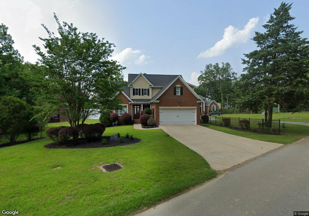
125 Cherry Ln Gilbert, SC 29054
Estimated Value: $677,000 - $1,066,000
4
Beds
3
Baths
2,607
Sq Ft
$349/Sq Ft
Est. Value
About This Home
This home is located at 125 Cherry Ln, Gilbert, SC 29054 and is currently estimated at $908,773, approximately $348 per square foot. 125 Cherry Ln is a home located in Lexington County with nearby schools including Centerville Elementary School, Gilbert Middle School, and Gilbert High School.
Ownership History
Date
Name
Owned For
Owner Type
Purchase Details
Closed on
Jun 14, 2019
Sold by
Patrick Wayne M and Patrick Joan M
Bought by
Patrick Wayne Mendes and Patrick Joan Provost
Current Estimated Value
Purchase Details
Closed on
Apr 30, 2012
Sold by
Asbill Brian S and Asbill Teresa B
Bought by
Patrick Wayne M and Patrick Joan M
Home Financials for this Owner
Home Financials are based on the most recent Mortgage that was taken out on this home.
Original Mortgage
$150,000
Outstanding Balance
$21,445
Interest Rate
4.01%
Mortgage Type
Future Advance Clause Open End Mortgage
Estimated Equity
$887,328
Purchase Details
Closed on
Nov 13, 2007
Sold by
Smith Marvin H
Bought by
Pomcreek Builders Inc
Purchase Details
Closed on
May 26, 2006
Sold by
Smith Marvin H
Bought by
Smith Marvin H
Create a Home Valuation Report for This Property
The Home Valuation Report is an in-depth analysis detailing your home's value as well as a comparison with similar homes in the area
Home Values in the Area
Average Home Value in this Area
Purchase History
| Date | Buyer | Sale Price | Title Company |
|---|---|---|---|
| Patrick Wayne Mendes | -- | None Available | |
| Patrick Wayne M | $535,000 | -- | |
| Pomcreek Builders Inc | $189,000 | None Available | |
| Smith Marvin H | -- | None Available |
Source: Public Records
Mortgage History
| Date | Status | Borrower | Loan Amount |
|---|---|---|---|
| Open | Patrick Wayne M | $150,000 |
Source: Public Records
Tax History
| Year | Tax Paid | Tax Assessment Tax Assessment Total Assessment is a certain percentage of the fair market value that is determined by local assessors to be the total taxable value of land and additions on the property. | Land | Improvement |
|---|---|---|---|---|
| 2024 | $2,684 | $18,909 | $8,945 | $9,964 |
| 2023 | $2,401 | $18,909 | $8,945 | $9,964 |
| 2022 | $2,403 | $18,909 | $8,945 | $9,964 |
| 2020 | $2,474 | $18,909 | $8,945 | $9,964 |
| 2019 | $2,136 | $16,443 | $6,400 | $10,043 |
| 2018 | $2,099 | $16,443 | $6,400 | $10,043 |
| 2017 | $2,028 | $16,443 | $6,400 | $10,043 |
| 2016 | $2,019 | $16,443 | $6,400 | $10,043 |
| 2014 | $2,154 | $18,060 | $7,600 | $10,460 |
| 2013 | -- | $18,060 | $7,600 | $10,460 |
Source: Public Records
Map
Nearby Homes
- 0 Misty Cir Unit 566318
- 417 Dot Ct
- 1628 Deep Cove Ln
- 1305 Rock Island Rd
- 870 Shore Rd
- 1301 Camping Rd
- 1366 Camping Rd
- 1148 Shull Island Rd
- 1233 Shull Island Rd
- 148 Pintail Lake Dr
- 102 Hideaway Cove Ct
- 527 Radnor Hunt Ct
- 532 Radnor Hunt Ct
- 204 Chamois Ct
- 1459 Bombing Range Rd
- 274 Pintail Lake Dr
- 110 Wood Duck Dr
- 278 Pintail Lake Dr
- 1 Downing Cir
- 501 Canasta Dr
- 129 Cherry Ln
- 115 Cherry Ln
- 133 Cherry Ln
- 137 Cherry Ln
- 124 Cherry Ln
- 132 Cherry Ln
- 143 Cherry Ln
- 116 Cherry Ln
- 108 Cherry Ln
- 1439 Misty Cir
- 1443 Misty Cir
- 1449 Misty Cir
- 1437 Misty Cir
- 0 Cherry Ln Unit 342804
- 147 Cherry Ln
- 1455 Misty Cir
- 0 Misty Cir Unit 547646
- 155 Cherry Ln
- 1256 Misty Ln
- 1440 Misty Cir
Your Personal Tour Guide
Ask me questions while you tour the home.