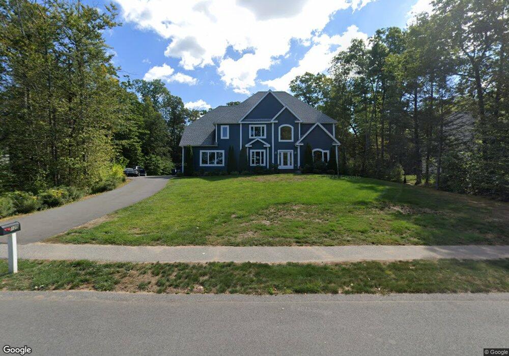
125 Linden Ridge Rd Amherst, MA 01002
Estimated Value: $1,125,000 - $1,169,000
5
Beds
50
Baths
4,050
Sq Ft
$285/Sq Ft
Est. Value
About This Home
This home is located at 125 Linden Ridge Rd, Amherst, MA 01002 and is currently estimated at $1,154,235, approximately $284 per square foot. 125 Linden Ridge Rd is a home located in Hampshire County with nearby schools including Fort River Elementary School, Amherst Regional Middle School, and Amherst Regional High School.
Ownership History
Date
Name
Owned For
Owner Type
Purchase Details
Closed on
Jun 11, 2018
Sold by
Bercume Construction L
Bought by
Crawford Ryan and Trien Leslie
Current Estimated Value
Home Financials for this Owner
Home Financials are based on the most recent Mortgage that was taken out on this home.
Original Mortgage
$648,000
Outstanding Balance
$560,411
Interest Rate
4.5%
Mortgage Type
Unknown
Estimated Equity
$593,824
Purchase Details
Closed on
May 16, 2014
Sold by
Tofino Associates Llc
Bought by
Dufour M C
Create a Home Valuation Report for This Property
The Home Valuation Report is an in-depth analysis detailing your home's value as well as a comparison with similar homes in the area
Home Values in the Area
Average Home Value in this Area
Purchase History
| Date | Buyer | Sale Price | Title Company |
|---|---|---|---|
| Crawford Ryan | $819,000 | -- | |
| Dufour M C | $190,000 | -- |
Source: Public Records
Mortgage History
| Date | Status | Borrower | Loan Amount |
|---|---|---|---|
| Open | Crawford Ryan | $648,000 |
Source: Public Records
Tax History Compared to Growth
Tax History
| Year | Tax Paid | Tax Assessment Tax Assessment Total Assessment is a certain percentage of the fair market value that is determined by local assessors to be the total taxable value of land and additions on the property. | Land | Improvement |
|---|---|---|---|---|
| 2025 | $204 | $1,138,700 | $218,100 | $920,600 |
| 2024 | $19,908 | $1,075,500 | $205,900 | $869,600 |
| 2023 | $18,802 | $935,400 | $187,100 | $748,300 |
| 2022 | $17,807 | $837,200 | $177,800 | $659,400 |
| 2021 | $16,989 | $778,600 | $164,700 | $613,900 |
| 2020 | $16,600 | $778,600 | $164,700 | $613,900 |
| 2019 | $15,840 | $726,600 | $164,700 | $561,900 |
| 2018 | $12,177 | $576,000 | $164,700 | $411,300 |
| 2017 | $1,716 | $78,600 | $78,600 | $0 |
| 2016 | $1,668 | $78,600 | $78,600 | $0 |
| 2015 | $3,221 | $156,800 | $156,800 | $0 |
Source: Public Records
Map
Nearby Homes
- 130 Linden Ridge Rd
- 100 Larkspur Dr
- 57 Tanglewood Rd
- 53 Pine Grove Unit 53
- 96 Logtown Rd
- 112 North St
- 14 Pebble Ridge Rd
- 61 S Valley Rd
- 265 Stanley St
- 324 Pomeroy Ln
- 0 Heatherstone Rd
- 41 Arnold Rd
- Lot B-2 N Gulf Rd
- 9 Harkness Rd
- 1730 S East St
- 365 Middle St
- 121 Amherst Rd
- 500 West St Unit 6
- Lot 1 Amherst Rd
- 170 E Hadley Rd Unit 123
- 125 Lindenridge Rd
- 125 Lindenridge Rd
- 129 Linden Ridge Rd
- 119 Linden Ridge Rd
- 118 Linden Ridge Rd
- 111 Linden Ridge Rd
- 103 Concord Way
- 114 Linden Ridge Rd
- 107 Concord Way
- 115 Concord Way
- 107 Lindenridge Rd
- 108 Linden Ridge Rd
- 118 Lindenridge Rd
- 19 Trillium Way
- 23 Trillium Way
- 99 Lindenridge Rd
- 15 Concord Way
- 15 Trillium Way
- 27 Trillium Way
- 102 Lindenridge Rd