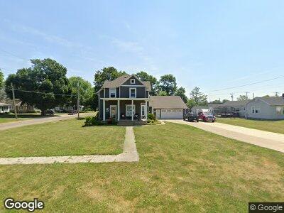
125 N Locust St Wyanet, IL 61379
Estimated Value: $116,000 - $189,000
--
Bed
--
Bath
--
Sq Ft
0.46
Acres
About This Home
This home is located at 125 N Locust St, Wyanet, IL 61379 and is currently estimated at $141,597. 125 N Locust St is a home located in Bureau County with nearby schools including Bureau Valley Wyanet Elementary School and Bureau Valley High School.
Ownership History
Date
Name
Owned For
Owner Type
Purchase Details
Closed on
Apr 15, 2005
Sold by
Hansen Joseph L and Brown Trisha L
Bought by
Smith Jason A and Smith Jamie J
Current Estimated Value
Home Financials for this Owner
Home Financials are based on the most recent Mortgage that was taken out on this home.
Original Mortgage
$84,966
Interest Rate
5.88%
Mortgage Type
FHA
Create a Home Valuation Report for This Property
The Home Valuation Report is an in-depth analysis detailing your home's value as well as a comparison with similar homes in the area
Home Values in the Area
Average Home Value in this Area
Purchase History
| Date | Buyer | Sale Price | Title Company |
|---|---|---|---|
| Smith Jason A | $86,500 | None Available |
Source: Public Records
Mortgage History
| Date | Status | Borrower | Loan Amount |
|---|---|---|---|
| Open | Smith Jason A | $40,000 | |
| Closed | Smtih Jason A | $78,400 | |
| Closed | Smith Jason A | $86,240 | |
| Closed | Smith Jason A | $84,966 |
Source: Public Records
Tax History Compared to Growth
Tax History
| Year | Tax Paid | Tax Assessment Tax Assessment Total Assessment is a certain percentage of the fair market value that is determined by local assessors to be the total taxable value of land and additions on the property. | Land | Improvement |
|---|---|---|---|---|
| 2024 | $3,320 | $43,909 | $3,898 | $40,011 |
| 2023 | $3,320 | $40,903 | $3,631 | $37,272 |
| 2022 | $3,097 | $38,010 | $3,374 | $34,636 |
| 2021 | $2,900 | $35,078 | $3,114 | $31,964 |
| 2020 | $2,885 | $34,614 | $3,073 | $31,541 |
| 2019 | $2,885 | $33,969 | $3,016 | $30,953 |
| 2018 | $2,621 | $32,287 | $2,867 | $29,420 |
| 2017 | $2,469 | $31,562 | $2,803 | $28,759 |
| 2016 | $2,570 | $30,560 | $2,714 | $27,846 |
| 2015 | -- | $26,833 | $0 | $26,833 |
| 2014 | -- | $29,448 | $2,615 | $26,833 |
| 2013 | -- | $30,172 | $2,679 | $27,493 |
Source: Public Records
Map
Nearby Homes
- 212 S Arch St
- 200 S Maple St
- 124 E 4th St
- 711 S Wyanet Walnut Rd
- 000 1200 St E
- 17580 1200 St E
- 320 Cedarhaven Dr
- 0 Park Ave W
- 625 N Linn St
- 1051 Lora Ave
- 1202 Margaret Dr
- 13422 State 40
- 1111 N Jacqualine Ln
- 703 Bryant Circle Dr
- 810 W Railroad Ave
- 520 W Crown St
- 220 N Pine St
- 425 W Clark St
- 423 S Randolph St
- 418 High St