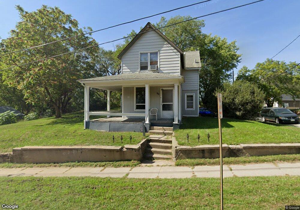
125 Paxton St Sioux City, IA 51105
East Side Sioux City NeighborhoodEstimated Value: $81,000 - $145,576
3
Beds
2
Baths
1,256
Sq Ft
$92/Sq Ft
Est. Value
About This Home
This home is located at 125 Paxton St, Sioux City, IA 51105 and is currently estimated at $115,394, approximately $91 per square foot. 125 Paxton St is a home located in Woodbury County with nearby schools including Unity Elementary School, East Middle School, and East High School.
Ownership History
Date
Name
Owned For
Owner Type
Purchase Details
Closed on
Apr 2, 2024
Sold by
Mad Real Estate Llc
Bought by
Montoya Jose
Current Estimated Value
Home Financials for this Owner
Home Financials are based on the most recent Mortgage that was taken out on this home.
Original Mortgage
$28,000
Interest Rate
6.62%
Mortgage Type
Construction
Purchase Details
Closed on
Feb 14, 2024
Sold by
Golden Madonna L
Bought by
Mad Real Estate Llc
Home Financials for this Owner
Home Financials are based on the most recent Mortgage that was taken out on this home.
Original Mortgage
$28,000
Interest Rate
6.62%
Mortgage Type
Construction
Create a Home Valuation Report for This Property
The Home Valuation Report is an in-depth analysis detailing your home's value as well as a comparison with similar homes in the area
Home Values in the Area
Average Home Value in this Area
Purchase History
| Date | Buyer | Sale Price | Title Company |
|---|---|---|---|
| Montoya Jose | $75,000 | None Listed On Document | |
| Mad Real Estate Llc | $35,000 | None Listed On Document |
Source: Public Records
Mortgage History
| Date | Status | Borrower | Loan Amount |
|---|---|---|---|
| Previous Owner | Mad Real Estate Llc | $28,000 |
Source: Public Records
Tax History Compared to Growth
Tax History
| Year | Tax Paid | Tax Assessment Tax Assessment Total Assessment is a certain percentage of the fair market value that is determined by local assessors to be the total taxable value of land and additions on the property. | Land | Improvement |
|---|---|---|---|---|
| 2025 | $1,716 | $103,900 | $24,700 | $79,200 |
| 2024 | $1,716 | $98,800 | $17,400 | $81,400 |
| 2023 | $1,498 | $98,800 | $17,400 | $81,400 |
| 2022 | $1,398 | $74,700 | $15,900 | $58,800 |
| 2021 | $1,398 | $70,900 | $15,900 | $55,000 |
| 2020 | $1,290 | $61,400 | $10,000 | $51,400 |
| 2019 | $998 | $44,200 | $0 | $0 |
| 2018 | $986 | $44,200 | $0 | $0 |
| 2017 | $986 | $27,800 | $0 | $0 |
| 2016 | $624 | $27,800 | $0 | $0 |
| 2015 | $783 | $27,800 | $5,200 | $22,600 |
| 2014 | $786 | $34,400 | $9,000 | $25,400 |
Source: Public Records
Map
Nearby Homes
- 101 Logan St
- 115 S Paxton St
- 301 Logan St
- 3031 Leech Ave
- 2806 2nd St
- 423 S Rustin St
- 2909 9th St
- 3011 7th St
- 916 S Helen St
- 3221 11th St
- 1005 S Paxton St
- 3212 Indiana Ave
- 1004 S Helen St
- 2610-12 Marshall Ave
- 1013 S Newton St
- 1107 Morningside Ave
- 904-822-821 Lewis Blvd Dubuque St
- 2534 Jay Ave
- 1220 Saint Marys St
- 1116 S Glass St