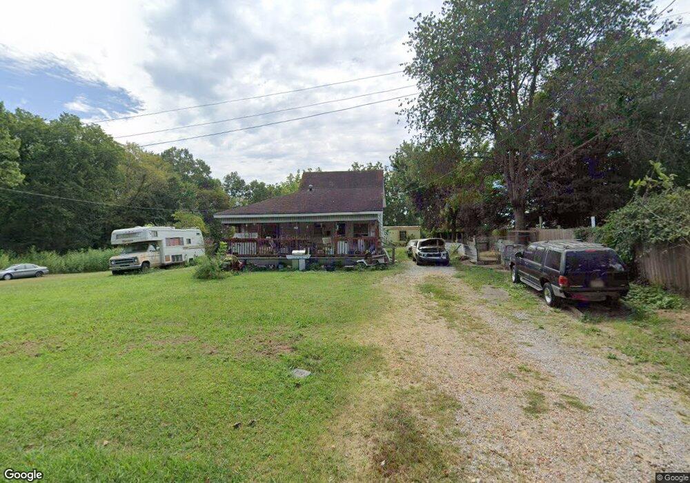
125 State St Puryear, TN 38251
Estimated Value: $40,000 - $112,000
--
Bed
1
Bath
1,200
Sq Ft
$64/Sq Ft
Est. Value
About This Home
This home is located at 125 State St, Puryear, TN 38251 and is currently estimated at $76,482, approximately $63 per square foot. 125 State St is a home located in Henry County.
Ownership History
Date
Name
Owned For
Owner Type
Purchase Details
Closed on
Apr 16, 2012
Sold by
Williams Marianna
Bought by
Ramsey Debbie Darlene
Current Estimated Value
Home Financials for this Owner
Home Financials are based on the most recent Mortgage that was taken out on this home.
Original Mortgage
$16,586
Interest Rate
4.13%
Mortgage Type
Cash
Purchase Details
Closed on
Jun 28, 2002
Sold by
Ann Whitehead Mary
Bought by
Upchurch Thomas J
Purchase Details
Closed on
Mar 1, 2002
Sold by
Kilgen Glenn R
Bought by
Ann Whitehead Mary
Purchase Details
Closed on
Feb 13, 2002
Sold by
Gallimore Jimmy M
Bought by
Kilgen Glenn R
Purchase Details
Closed on
May 2, 2001
Sold by
Teresa Page
Bought by
Jimmy Gallimore
Purchase Details
Closed on
May 1, 2001
Bought by
Kilgen Glenn R
Purchase Details
Closed on
Jul 20, 1976
Bought by
Gibson Thomas H
Create a Home Valuation Report for This Property
The Home Valuation Report is an in-depth analysis detailing your home's value as well as a comparison with similar homes in the area
Home Values in the Area
Average Home Value in this Area
Purchase History
| Date | Buyer | Sale Price | Title Company |
|---|---|---|---|
| Ramsey Debbie Darlene | $16,586 | -- | |
| Upchurch Thomas J | $23,300 | -- | |
| Ann Whitehead Mary | $16,500 | -- | |
| Kilgen Glenn R | $14,500 | -- | |
| Jimmy Gallimore | $13,000 | -- | |
| Kilgen Glenn R | $14,500 | -- | |
| Gibson Thomas H | -- | -- |
Source: Public Records
Mortgage History
| Date | Status | Borrower | Loan Amount |
|---|---|---|---|
| Closed | Ramsey Debbie Darlene | $16,586 |
Source: Public Records
Tax History Compared to Growth
Tax History
| Year | Tax Paid | Tax Assessment Tax Assessment Total Assessment is a certain percentage of the fair market value that is determined by local assessors to be the total taxable value of land and additions on the property. | Land | Improvement |
|---|---|---|---|---|
| 2024 | $144 | $7,450 | $2,125 | $5,325 |
| 2023 | $141 | $7,450 | $2,125 | $5,325 |
| 2022 | $141 | $7,450 | $2,125 | $5,325 |
| 2021 | $141 | $7,450 | $2,125 | $5,325 |
| 2020 | $185 | $9,775 | $2,125 | $7,650 |
| 2019 | $168 | $8,025 | $1,925 | $6,100 |
| 2018 | $168 | $8,025 | $1,925 | $6,100 |
| 2017 | $168 | $8,025 | $1,925 | $6,100 |
| 2016 | $165 | $8,025 | $1,925 | $6,100 |
| 2015 | $176 | $8,025 | $1,925 | $6,100 |
| 2014 | $155 | $8,025 | $1,925 | $6,100 |
| 2013 | $155 | $7,054 | $0 | $0 |
Source: Public Records
Map
Nearby Homes
- 0 State Line Rd E
- 000 State Line Rd E
- 0 Highway 641 N Unit 133861
- 13570 Highway 641 N
- 505 5th St
- 00 Atkins Trail
- 820 3rd St
- 000 Perkins Rd
- 0 Perkins Rd
- 00 Perkins Rd
- 1230 Perkins Rd
- 200 Morris Rd
- 317 Stokes St
- 236 W Chestnut St
- 9620 Hwy 641n
- 0 Highway 140 E
- 2794 Perkins Rd
- 10433 Shady Grove Rd
- 715 Shoemaker Rd
- 00 641 S