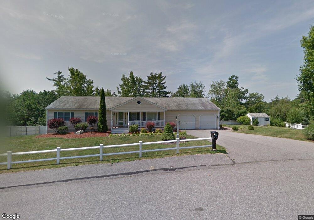
125 Sue Ann Dr Dracut, MA 01826
Estimated Value: $722,000 - $764,000
3
Beds
2
Baths
1,960
Sq Ft
$376/Sq Ft
Est. Value
About This Home
This home is located at 125 Sue Ann Dr, Dracut, MA 01826 and is currently estimated at $736,105, approximately $375 per square foot. 125 Sue Ann Dr is a home located in Middlesex County with nearby schools including George H. Englesby Elementary School, Richardson Middle School, and Dracut Senior High School.
Ownership History
Date
Name
Owned For
Owner Type
Purchase Details
Closed on
Sep 10, 2018
Sold by
Jones Cheryl L and Jones Brian E
Bought by
Brian & Cheryl Jones Ft
Current Estimated Value
Purchase Details
Closed on
Jun 28, 1999
Sold by
Suburban No Construct
Bought by
Jones Cheryl L and Jones Brian E
Home Financials for this Owner
Home Financials are based on the most recent Mortgage that was taken out on this home.
Original Mortgage
$216,400
Interest Rate
7.09%
Mortgage Type
Purchase Money Mortgage
Create a Home Valuation Report for This Property
The Home Valuation Report is an in-depth analysis detailing your home's value as well as a comparison with similar homes in the area
Home Values in the Area
Average Home Value in this Area
Purchase History
| Date | Buyer | Sale Price | Title Company |
|---|---|---|---|
| Brian & Cheryl Jones Ft | -- | -- | |
| Jones Cheryl L | $254,624 | -- |
Source: Public Records
Mortgage History
| Date | Status | Borrower | Loan Amount |
|---|---|---|---|
| Previous Owner | Jones Cheryl L | $200,000 | |
| Previous Owner | Jones Cheryl L | $202,000 | |
| Previous Owner | Jones Cheryl L | $205,000 | |
| Previous Owner | Jones Cheryl L | $216,400 |
Source: Public Records
Tax History Compared to Growth
Tax History
| Year | Tax Paid | Tax Assessment Tax Assessment Total Assessment is a certain percentage of the fair market value that is determined by local assessors to be the total taxable value of land and additions on the property. | Land | Improvement |
|---|---|---|---|---|
| 2025 | $7,307 | $722,000 | $252,700 | $469,300 |
| 2024 | $7,381 | $706,300 | $240,800 | $465,500 |
| 2023 | $7,068 | $610,400 | $209,400 | $401,000 |
| 2022 | $7,241 | $589,200 | $190,500 | $398,700 |
| 2021 | $6,994 | $537,600 | $173,000 | $364,600 |
| 2020 | $6,683 | $500,600 | $167,800 | $332,800 |
| 2019 | $6,522 | $474,300 | $159,700 | $314,600 |
| 2018 | $6,001 | $424,400 | $159,700 | $264,700 |
| 2017 | $5,836 | $424,400 | $159,700 | $264,700 |
| 2016 | $5,675 | $382,400 | $160,500 | $221,900 |
| 2015 | $5,466 | $366,100 | $160,500 | $205,600 |
| 2014 | $5,070 | $349,900 | $160,500 | $189,400 |
Source: Public Records
Map
Nearby Homes
- 50 Stephen Ave
- 999 Hildreth St
- 190 Old Rd
- 83 Turgeon Ave
- 174 Old Rd
- 35 Camilla Ave
- 157 Old Rd
- 20 Esther Way Unit 11
- 26 Frank St
- 19 Esther Way Unit Lot 10
- 53 Vinal St
- 321 Old Marsh Hill Rd
- 14 Louis Farm Rd Unit 14
- 74 Tennis Plaza Rd Unit 34
- 1572 Bridge St
- 100 Cass Ave Unit A13
- 167 Betty Ann Ln
- 121 Old Marsh Hill Rd
- 1905 Lakeview Ave
- 67 Lincoln Ln