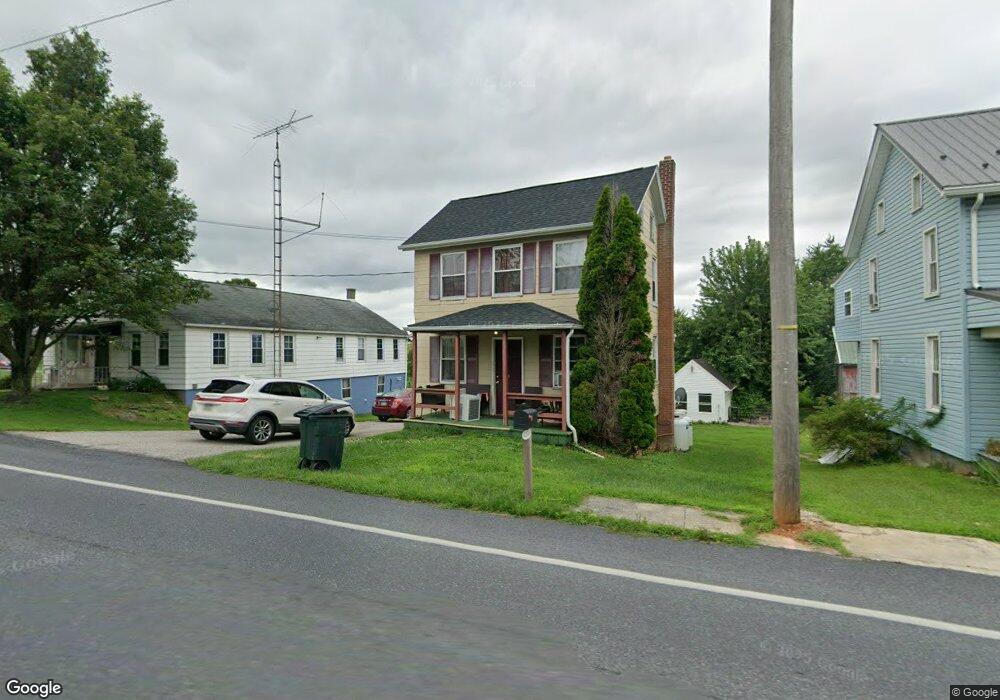
12518 Winterstown Rd Felton, PA 17322
Estimated Value: $131,000 - $253,000
2
Beds
1
Bath
942
Sq Ft
$192/Sq Ft
Est. Value
About This Home
This home is located at 12518 Winterstown Rd, Felton, PA 17322 and is currently estimated at $180,878, approximately $192 per square foot. 12518 Winterstown Rd is a home located in York County with nearby schools including North Hopewell-Winterstown Elementary School, Red Lion Area Junior High School, and Red Lion Area Senior High School.
Ownership History
Date
Name
Owned For
Owner Type
Purchase Details
Closed on
Mar 15, 2012
Sold by
Deutsche Bank National Trust Company
Bought by
Slcl Anderson
Current Estimated Value
Purchase Details
Closed on
Mar 9, 2011
Sold by
Lovas Janos and Lovas Anna
Bought by
Deutsche Bank National Trust Company
Purchase Details
Closed on
Dec 2, 2002
Sold by
First Union National Bank
Bought by
Ridenour Michael B
Purchase Details
Closed on
Jun 27, 2001
Sold by
Forrester Michael A
Bought by
Pennsylvania Housing Finance Agency
Create a Home Valuation Report for This Property
The Home Valuation Report is an in-depth analysis detailing your home's value as well as a comparison with similar homes in the area
Home Values in the Area
Average Home Value in this Area
Purchase History
| Date | Buyer | Sale Price | Title Company |
|---|---|---|---|
| Slcl Anderson | $39,199 | None Available | |
| Deutsche Bank National Trust Company | $2,555 | None Available | |
| Ridenour Michael B | $32,000 | -- | |
| Pennsylvania Housing Finance Agency | $1,238 | -- |
Source: Public Records
Tax History Compared to Growth
Tax History
| Year | Tax Paid | Tax Assessment Tax Assessment Total Assessment is a certain percentage of the fair market value that is determined by local assessors to be the total taxable value of land and additions on the property. | Land | Improvement |
|---|---|---|---|---|
| 2025 | $2,432 | $77,810 | $36,370 | $41,440 |
| 2024 | $2,356 | $77,810 | $36,370 | $41,440 |
| 2023 | $2,356 | $77,810 | $36,370 | $41,440 |
| 2022 | $2,356 | $77,810 | $36,370 | $41,440 |
| 2021 | $2,278 | $77,810 | $36,370 | $41,440 |
| 2020 | $2,278 | $77,810 | $36,370 | $41,440 |
| 2019 | $2,270 | $77,810 | $36,370 | $41,440 |
| 2018 | $2,270 | $77,810 | $36,370 | $41,440 |
| 2017 | $2,270 | $77,810 | $36,370 | $41,440 |
| 2016 | $0 | $77,810 | $36,370 | $41,440 |
| 2015 | -- | $77,810 | $36,370 | $41,440 |
| 2014 | -- | $77,810 | $36,370 | $41,440 |
Source: Public Records
Map
Nearby Homes
- 0 Oak Ridge Ave
- 5714 Spruce Rd
- 12706 High Point Rd
- 16434 Cross Roads Ave
- 4389 Hess Rd
- 1680 Wood Crest Ln
- 13859 Ebaugh Rd
- 0 Seitz Rd
- 290 Neff Rd
- 786 Arbor Dr
- 0 Kreutz Creek Off Unit PAYK2094814
- 0 Swamp Hollow Ln
- 209 Forest Hills Rd
- 8219 Lehman Rd
- 113 Forest Hills Rd
- 276 Oakbrook Dr
- 11201-11207 Susquehanna Trail S
- 175 Country Ridge Dr
- 705 Summit Dr
- 250 Country Ridge Dr
- 12510 Winterstown Rd
- 12530 Winterstown Rd
- 12513 Winterstown Rd
- 12497 Winterstown Rd
- 12535 Winterstown Rd
- 12489 Winterstown Rd
- 12547 Winterstown Rd
- 12568 Winterstown Rd
- 12561 Winterstown Rd
- 12467 Winterstown Rd
- 12576 Winterstown Rd
- 12452 Winterstown Rd
- 12581 Winterstown Rd
- 5982 Swamp Rd
- 12283 Hill St
- 12596 Winterstown Rd
- 12612 Winterstown Rd
- 12603 Winterstown Rd
- 11805 Mount Olivet Rd
- 12415 Winterstown Rd