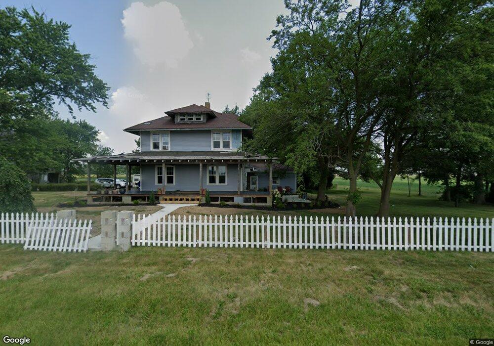
12544 County Road H Wauseon, OH 43567
Estimated Value: $193,000 - $341,000
4
Beds
2
Baths
1,992
Sq Ft
$129/Sq Ft
Est. Value
About This Home
This home is located at 12544 County Road H, Wauseon, OH 43567 and is currently estimated at $257,650, approximately $129 per square foot. 12544 County Road H is a home located in Fulton County with nearby schools including Delta Elementary School, Pike-Delta-York Middle School, and Pike-Delta-York High School.
Ownership History
Date
Name
Owned For
Owner Type
Purchase Details
Closed on
Nov 6, 2018
Sold by
Stuber Kristen
Bought by
Snyder Joseph
Current Estimated Value
Purchase Details
Closed on
Jan 23, 2009
Sold by
Secretary Of Veterans Affairs
Bought by
Snyder Joseph W and Stuber Kristen D
Purchase Details
Closed on
Jul 25, 2008
Sold by
Mielke Karen K
Bought by
Secretary Of Veterans Affairs
Purchase Details
Closed on
Jan 1, 1990
Bought by
Mielke Karen K
Create a Home Valuation Report for This Property
The Home Valuation Report is an in-depth analysis detailing your home's value as well as a comparison with similar homes in the area
Home Values in the Area
Average Home Value in this Area
Purchase History
| Date | Buyer | Sale Price | Title Company |
|---|---|---|---|
| Snyder Joseph | -- | None Available | |
| Snyder Joseph W | $31,000 | Attorney | |
| Secretary Of Veterans Affairs | $44,667 | None Available | |
| Mielke Karen K | -- | -- |
Source: Public Records
Tax History Compared to Growth
Tax History
| Year | Tax Paid | Tax Assessment Tax Assessment Total Assessment is a certain percentage of the fair market value that is determined by local assessors to be the total taxable value of land and additions on the property. | Land | Improvement |
|---|---|---|---|---|
| 2024 | $1,766 | $38,890 | $22,720 | $16,170 |
| 2023 | $1,769 | $38,890 | $22,720 | $16,170 |
| 2022 | $1,435 | $28,570 | $18,940 | $9,630 |
| 2021 | $1,400 | $26,750 | $18,940 | $7,810 |
| 2020 | $1,323 | $25,490 | $18,940 | $6,550 |
| 2019 | $1,086 | $21,770 | $15,680 | $6,090 |
| 2018 | $1,069 | $21,280 | $15,680 | $5,600 |
| 2017 | $1,092 | $21,880 | $15,680 | $6,200 |
| 2016 | $1,097 | $20,790 | $15,680 | $5,110 |
| 2015 | $1,030 | $20,790 | $15,680 | $5,110 |
| 2014 | $1,026 | $20,790 | $15,680 | $5,110 |
| 2013 | $1,076 | $21,530 | $12,780 | $8,750 |
Source: Public Records
Map
Nearby Homes
- 0 County Road H
- 8453 County Road 13
- 7620 County Road 12
- 7373 County Road 12
- 13242 Us Highway 20a
- 13354 U S 20a
- 1209 Apache Dr
- 460 Airport Hwy
- Integrity 1830 Plan at Arrowhead Trails
- integrity 2280 Plan at Arrowhead Trails
- Integrity 2080 Plan at Arrowhead Trails
- 1090 Seneca Dr
- 1062 Seneca Dr
- 1058 Seneca Dr
- 1066 Seneca Dr
- 14578 Us Highway 20a
- 14900 County Road H
- 14900 W Co Rd H
- 1338 N Park Ln
- 801 N Shoop Ave
- 12544 County Road H
- 12471 County Road H
- 12697 County Road H
- 12835 County Road H
- 12263 County Road H
- 12921 County Road H
- 8446 County Road 12 1
- 8044 County Road 12 1
- 7768 County Road 13
- 7951 County Road 13
- 8288 County Road 13
- 13065 County Road H
- 11970 County Road H
- 00 County Road H
- 7980 County Road 12
- 13131 County Road H
- 8529 County Road 12 1
- 7721 County Road 12
- 7870 County Road 12
- 7707 County Road 12