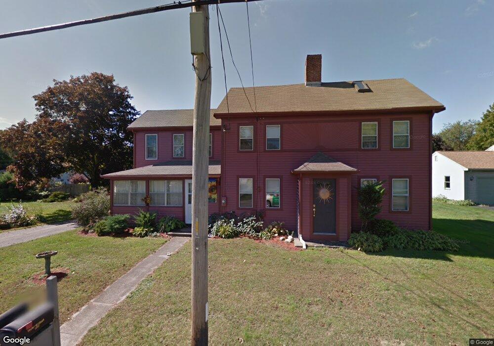
1257 Main St Acushnet, MA 02743
Estimated Value: $524,000 - $618,000
2
Beds
2
Baths
3,106
Sq Ft
$187/Sq Ft
Est. Value
About This Home
This home is located at 1257 Main St, Acushnet, MA 02743 and is currently estimated at $579,346, approximately $186 per square foot. 1257 Main St is a home located in Bristol County with nearby schools including Acushnet Elementary School and Albert F Ford Middle School.
Ownership History
Date
Name
Owned For
Owner Type
Purchase Details
Closed on
Dec 23, 2022
Sold by
Deschamps Roger D and Deschamps Patricia A
Bought by
Sutcliffe Robert F and Sutcliffe Michelle M
Current Estimated Value
Home Financials for this Owner
Home Financials are based on the most recent Mortgage that was taken out on this home.
Original Mortgage
$372,000
Outstanding Balance
$360,736
Interest Rate
7.08%
Mortgage Type
Purchase Money Mortgage
Estimated Equity
$218,610
Purchase Details
Closed on
Mar 12, 1970
Bought by
Deschamps Roger D and Deschamps Patricia A
Create a Home Valuation Report for This Property
The Home Valuation Report is an in-depth analysis detailing your home's value as well as a comparison with similar homes in the area
Purchase History
| Date | Buyer | Sale Price | Title Company |
|---|---|---|---|
| Sutcliffe Robert F | $500,000 | None Available | |
| Deschamps Roger D | -- | -- |
Source: Public Records
Mortgage History
| Date | Status | Borrower | Loan Amount |
|---|---|---|---|
| Open | Sutcliffe Robert F | $372,000 | |
| Previous Owner | Deschamps Roger D | $50,000 |
Source: Public Records
Tax History
| Year | Tax Paid | Tax Assessment Tax Assessment Total Assessment is a certain percentage of the fair market value that is determined by local assessors to be the total taxable value of land and additions on the property. | Land | Improvement |
|---|---|---|---|---|
| 2025 | $54 | $499,900 | $187,600 | $312,300 |
| 2024 | $5,492 | $481,300 | $177,900 | $303,400 |
| 2023 | $5,750 | $479,200 | $161,500 | $317,700 |
| 2022 | $5,766 | $434,500 | $152,500 | $282,000 |
| 2021 | $5,291 | $382,600 | $152,500 | $230,100 |
| 2020 | $5,208 | $373,600 | $143,500 | $230,100 |
| 2019 | $4,945 | $348,700 | $137,500 | $211,200 |
| 2018 | $4,812 | $333,700 | $137,500 | $196,200 |
| 2017 | $4,703 | $325,700 | $137,500 | $188,200 |
| 2016 | $4,491 | $309,100 | $137,500 | $171,600 |
| 2015 | $4,414 | $309,100 | $137,500 | $171,600 |
Source: Public Records
Map
Nearby Homes
- 199 Quaker Ln
- 0 Keene Rd Unit 73459818
- 168 Keene Rd
- 0 Land Way Unit 73479153
- 898 Tobey St
- 247 Braley Hill Rd
- 125 Doctor Braley Rd
- 4597 Acushnet Ave
- 973 Pembroke St
- SS Charbonneau Ln
- 34 Poplar Rd
- 18 Wordell St
- 489 Main St
- 3 Abraham Ave
- 329 Middle Rd
- 145 Heritage Dr
- 134 Nyes Ln
- 1015 Forbes St
- 78 Greenbrier Dr
- 363 Main St
Your Personal Tour Guide
Ask me questions while you tour the home.