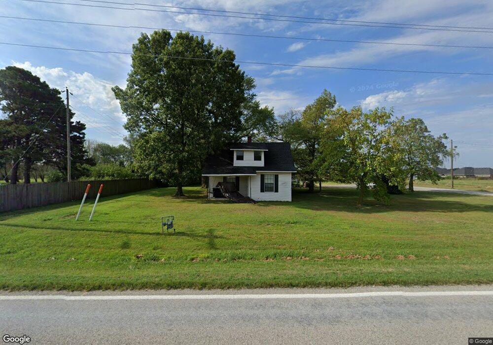
1257 W Main St Gentry, AR 72734
Estimated Value: $269,175 - $373,000
--
Bed
--
Bath
798
Sq Ft
$389/Sq Ft
Est. Value
About This Home
This home is located at 1257 W Main St, Gentry, AR 72734 and is currently estimated at $310,544, approximately $389 per square foot. 1257 W Main St is a home with nearby schools including Gentry Intermediate School, Gentry Primary School, and Gentry Middle School.
Ownership History
Date
Name
Owned For
Owner Type
Purchase Details
Closed on
Jul 5, 2004
Bought by
City Gentry (.11 Ac)
Current Estimated Value
Purchase Details
Closed on
May 7, 2004
Bought by
Wade
Purchase Details
Closed on
Jan 17, 1995
Bought by
Bader
Purchase Details
Closed on
Dec 31, 1992
Bought by
Disabled Vets
Purchase Details
Closed on
Nov 3, 1992
Bought by
Bader
Purchase Details
Closed on
Aug 28, 1992
Bought by
Disabled Vets Etal
Purchase Details
Closed on
Feb 3, 1987
Bought by
Bader
Purchase Details
Closed on
Jul 10, 1984
Bought by
Covey
Create a Home Valuation Report for This Property
The Home Valuation Report is an in-depth analysis detailing your home's value as well as a comparison with similar homes in the area
Home Values in the Area
Average Home Value in this Area
Purchase History
| Date | Buyer | Sale Price | Title Company |
|---|---|---|---|
| City Gentry (.11 Ac) | -- | -- | |
| Wade | -- | -- | |
| Bader | -- | -- | |
| Disabled Vets | -- | -- | |
| Bader | -- | -- | |
| Disabled Vets Etal | $30,000 | -- | |
| Bader | $34,000 | -- | |
| Covey | $28,000 | -- |
Source: Public Records
Tax History Compared to Growth
Tax History
| Year | Tax Paid | Tax Assessment Tax Assessment Total Assessment is a certain percentage of the fair market value that is determined by local assessors to be the total taxable value of land and additions on the property. | Land | Improvement |
|---|---|---|---|---|
| 2025 | $1,527 | $30,482 | $7,490 | $22,992 |
| 2024 | $2,694 | $48,721 | $7,490 | $41,231 |
| 2023 | $669 | $20,230 | $5,350 | $14,880 |
| 2022 | $330 | $20,230 | $5,350 | $14,880 |
| 2021 | $328 | $20,230 | $5,350 | $14,880 |
| 2020 | $331 | $13,440 | $1,930 | $11,510 |
| 2019 | $331 | $13,440 | $1,930 | $11,510 |
| 2018 | $356 | $13,440 | $1,930 | $11,510 |
| 2017 | $356 | $13,440 | $1,930 | $11,510 |
| 2016 | $356 | $13,440 | $1,930 | $11,510 |
| 2015 | $655 | $11,840 | $2,400 | $9,440 |
| 2014 | $655 | $11,840 | $2,400 | $9,440 |
Source: Public Records
Map
Nearby Homes
- 108 White Oak St
- 104 White Oak St
- 216 White Oak St
- 300 White Oak St
- 200 Post Oak Ave
- 0 Orchard
- 904 W Main St
- 225 Whitten Ave
- 309 Whitten Ave
- 301 Whitten Ave
- 313 Whitten Ave
- 305 Whitten Ave
- 217 Whitten Ave
- Rc Morgan Plan at Crowder
- RC Kinsley II Plan at Crowder
- RC Baltimore Plan at Crowder
- RC Coleman Plan at Crowder
- RC Carnegie II Plan at Crowder
- RC Glenwood Plan at Crowder
- RC Raleigh Plan at Crowder
- 1265 W Main St
- 1245 W Main St
- 1339 W Main St
- 1173 W Main St
- 11 Lots Orchard Dr
- Lot 23 Orchard Dr
- Lot 17 Orchard Dr
- Lot 13 Orchard Dr
- Lot 11 Orchard Dr
- Lot 9 Orchard Dr
- 0 Lot 11 Orchard Dr Unit 1015169
- 0 Lot 23 Orchard Dr Unit 1015177
- 0 Lot 9 Orchard Dr Unit 1015167
- 201 Miles Ave
- Lot 22 Orchard Dr
- Lot 16 Orchard Dr
- Lot 14 Orchard Dr
- Lot 12 Orchard Dr
- Lot 10 Orchard Dr
- Lot 8 Orchard Dr