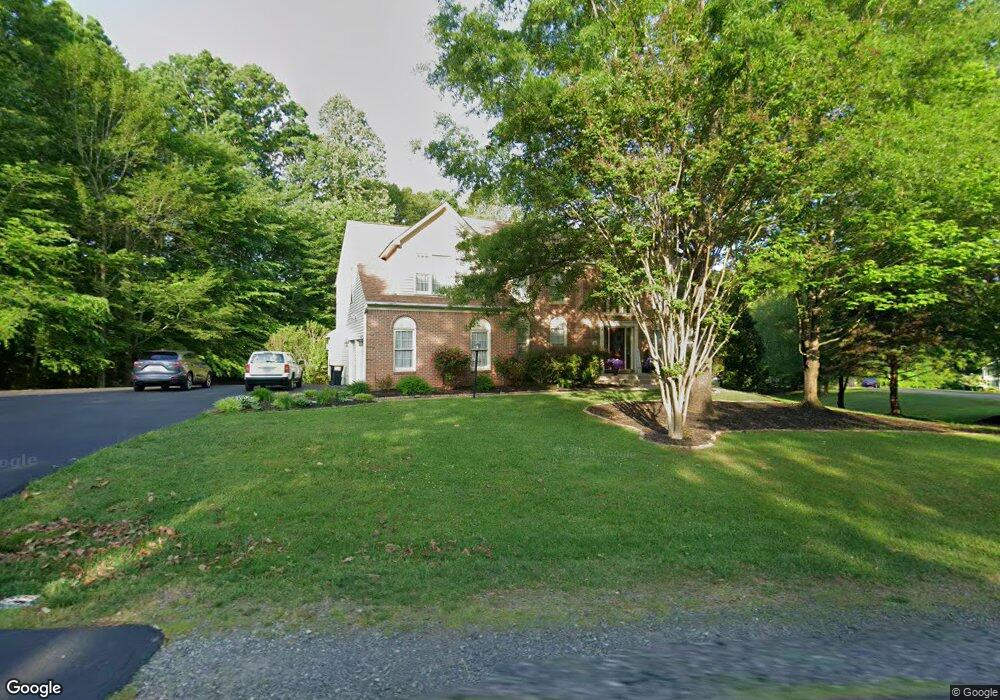
12574 Spiller Ln Manassas, VA 20112
South Manassas NeighborhoodEstimated Value: $958,018 - $1,098,000
5
Beds
4
Baths
3,736
Sq Ft
$275/Sq Ft
Est. Value
About This Home
This home is located at 12574 Spiller Ln, Manassas, VA 20112 and is currently estimated at $1,029,255, approximately $275 per square foot. 12574 Spiller Ln is a home located in Prince William County with nearby schools including Charles J. Colgan Senior High School, Thurgood Marshall Elementary School, and Louise A. Benton Middle School.
Ownership History
Date
Name
Owned For
Owner Type
Purchase Details
Closed on
May 11, 1999
Sold by
Barrington K Hovnanian @
Bought by
Carey Michael A
Current Estimated Value
Home Financials for this Owner
Home Financials are based on the most recent Mortgage that was taken out on this home.
Original Mortgage
$240,000
Outstanding Balance
$61,396
Interest Rate
6.92%
Estimated Equity
$967,859
Create a Home Valuation Report for This Property
The Home Valuation Report is an in-depth analysis detailing your home's value as well as a comparison with similar homes in the area
Home Values in the Area
Average Home Value in this Area
Purchase History
| Date | Buyer | Sale Price | Title Company |
|---|---|---|---|
| Carey Michael A | $307,600 | -- |
Source: Public Records
Mortgage History
| Date | Status | Borrower | Loan Amount |
|---|---|---|---|
| Open | Carey Michael A | $240,000 |
Source: Public Records
Tax History
| Year | Tax Paid | Tax Assessment Tax Assessment Total Assessment is a certain percentage of the fair market value that is determined by local assessors to be the total taxable value of land and additions on the property. | Land | Improvement |
|---|---|---|---|---|
| 2025 | $8,381 | $909,400 | $206,800 | $702,600 |
| 2024 | $8,381 | $842,700 | $191,600 | $651,100 |
| 2023 | $8,431 | $810,300 | $187,600 | $622,700 |
| 2022 | $8,609 | $767,000 | $176,700 | $590,300 |
| 2021 | $7,753 | $638,300 | $165,000 | $473,300 |
| 2020 | $8,759 | $565,100 | $165,400 | $399,700 |
| 2019 | $8,861 | $571,700 | $165,400 | $406,300 |
| 2018 | $7,164 | $593,300 | $165,400 | $427,900 |
| 2017 | $7,088 | $578,300 | $171,300 | $407,000 |
| 2016 | $6,564 | $540,100 | $167,400 | $372,700 |
| 2015 | $6,791 | $558,400 | $167,400 | $391,000 |
| 2014 | $6,791 | $547,200 | $164,500 | $382,700 |
Source: Public Records
Map
Nearby Homes
- 6658 Fox Den Rd
- 6233 Alistair Dr
- 6338 Etheridge Ln
- 12170 Ivakota Ct
- 12704 Purcell Rd
- 11920 Coloriver Rd
- 6242 Oakland Dr
- 12841 Hoadly Manor Dr
- 13048 Brierly Forest Ct
- 12790 Lost Creek Ct
- 12357 Purcell Rd
- 11218 Stonebrook Dr
- 13485 Carapace Ct
- 13379 Packard Dr
- 13217 Nickleson Dr
- 5897 Penacle Ct
- 13357 Pelican Rd
- 5356 Wade Ln
- 13370 Nationville Ln
- 13450 Orangewood Dr
- 12571 Spiller Ln
- 6385 Horsely Ct
- 12575 Spiller Ln
- 6370 Popwicke Ct
- 12563 Spiller Ln
- 12567 Spiller Ln
- 6378 Popwicke Ct
- 12564 Spiller Ln
- 12583 Spiller Ln
- 12579 Spiller Ln
- 12551 Spiller Ln
- 6384 Horsely Ct
- 12560 Spiller Ln
- 6383 Popwicke Ct
- 12547 Spiller Ln
- 12590 Spiller Ln
- 6388 Horsely Ct
- 6379 Popwicke Ct
- 6375 Popwicke Ct
- 12587 Spiller Ln
Your Personal Tour Guide
Ask me questions while you tour the home.