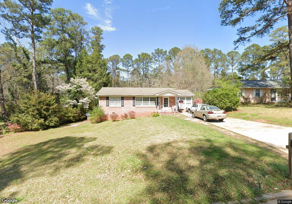
126 Bonaventure Dr Lagrange, GA 30241
Estimated Value: $113,000 - $198,000
2
Beds
1
Bath
1,080
Sq Ft
$137/Sq Ft
Est. Value
About This Home
This home is located at 126 Bonaventure Dr, Lagrange, GA 30241 and is currently estimated at $148,483, approximately $137 per square foot. 126 Bonaventure Dr is a home located in Troup County with nearby schools including Franklin Forest Elementary School, Hollis Hand Elementary School, and Ethel W. Kight Elementary School.
Ownership History
Date
Name
Owned For
Owner Type
Purchase Details
Closed on
Dec 27, 2016
Sold by
Carol Reva
Bought by
Greenwood Properties Llc
Current Estimated Value
Purchase Details
Closed on
Apr 19, 1996
Sold by
Jewell Mallory N and Jewell B
Bought by
Pace Larry Donald and Trenton Reva C
Purchase Details
Closed on
Jan 30, 1981
Sold by
Cantrell George H
Bought by
Jewell Mallory N and Jewell B
Purchase Details
Closed on
Jan 29, 1981
Bought by
Cantrell George H
Purchase Details
Closed on
Jan 19, 1974
Sold by
Cantrell George H and Cantrell Linda B
Purchase Details
Closed on
Nov 1, 1966
Bought by
Cantrell George H and Cantrell Linda B
Create a Home Valuation Report for This Property
The Home Valuation Report is an in-depth analysis detailing your home's value as well as a comparison with similar homes in the area
Purchase History
| Date | Buyer | Sale Price | Title Company |
|---|---|---|---|
| Greenwood Properties Llc | $62,500 | -- | |
| Pace Larry Donald | -- | -- | |
| Jewell Mallory N | $37,000 | -- | |
| Cantrell George H | -- | -- | |
| -- | -- | -- | |
| Cantrell George H | -- | -- | |
| -- | $4,400 | -- |
Source: Public Records
Tax History
| Year | Tax Paid | Tax Assessment Tax Assessment Total Assessment is a certain percentage of the fair market value that is determined by local assessors to be the total taxable value of land and additions on the property. | Land | Improvement |
|---|---|---|---|---|
| 2025 | $1,159 | $42,492 | $8,000 | $34,492 |
| 2024 | $987 | $36,172 | $8,000 | $28,172 |
| 2023 | $989 | $36,260 | $8,320 | $27,940 |
| 2022 | $971 | $34,780 | $8,320 | $26,460 |
| 2021 | $872 | $28,920 | $8,320 | $20,600 |
| 2020 | $872 | $28,920 | $8,320 | $20,600 |
| 2019 | $705 | $23,368 | $7,088 | $16,280 |
| 2018 | $705 | $23,368 | $7,088 | $16,280 |
| 2017 | $705 | $23,368 | $7,088 | $16,280 |
| 2016 | $629 | $22,835 | $7,088 | $15,747 |
| 2015 | $642 | $23,260 | $7,513 | $15,747 |
| 2014 | $620 | $22,527 | $7,512 | $15,015 |
| 2013 | -- | $23,857 | $7,512 | $16,345 |
Source: Public Records
Map
Nearby Homes
- 224 Rutland Cir
- 210 Hearthstone Dr
- 203 Bonaventure Dr
- 87 Youngs Mill Rd
- 115 Clara Jean Ct
- 110 Lenox Cir
- 212 Cleveland Dr
- 204 Cleveland Dr
- 107 N Barnard Ave
- 0 N Barnard Ave
- 616 S Harlem Cir
- 706 N Harlem Cir
- 5 Curran Ave
- 102 Dogwood Dr
- 131 Foch St
- 509 Youngs Mill Rd
- 101 Sarah Ln
- 412 Sweetwood Ct Unit A36
- 202 Park Hill Dr
- 109 Sarah Ln
- 124 Bonaventure Dr
- 130 Bonaventure Dr
- 122 Bonaventure Dr
- 132 Bonaventure Dr
- 120 Bonaventure Dr
- 125 Bonaventure Dr
- 127 Bonaventure Dr
- 123 Bonaventure Dr
- 129 Bonaventure Dr
- 121 Bonaventure Dr
- 134 Bonaventure Dr
- 119 Bonaventure Dr
- 133 Bonaventure Dr
- 116 Bonaventure Dr
- 117 Bonaventure Dr
- 136 Bonaventure Dr
- 241 Rutland Cir
- 239 Rutland Cir
- 243 Rutland Cir
- 237 Rutland Cir
Your Personal Tour Guide
Ask me questions while you tour the home.