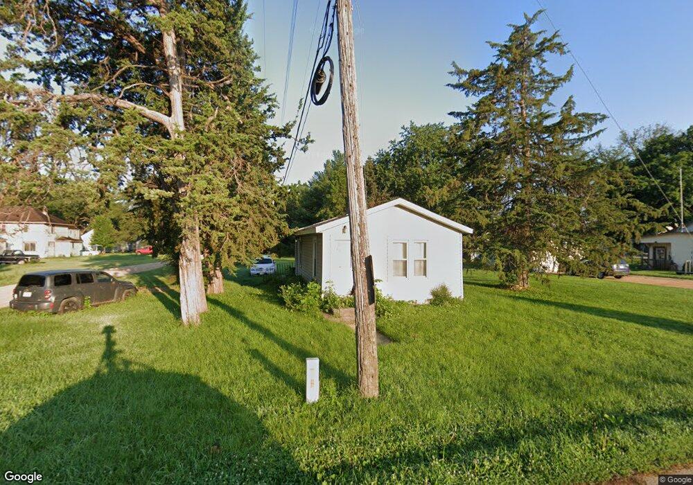
126 Hemlock Rd Mankato, MN 56001
Estimated Value: $113,888 - $199,000
1
Bed
1
Bath
652
Sq Ft
$227/Sq Ft
Est. Value
About This Home
This home is located at 126 Hemlock Rd, Mankato, MN 56001 and is currently estimated at $148,222, approximately $227 per square foot. 126 Hemlock Rd is a home located in Blue Earth County with nearby schools including Roosevelt Elementary School, Dakota Meadows Middle School, and Mankato West Senior High School.
Ownership History
Date
Name
Owned For
Owner Type
Purchase Details
Closed on
Aug 29, 2025
Sold by
J & P Seppmann Properties Llc
Bought by
Beaver Ave Rentals Llc
Current Estimated Value
Purchase Details
Closed on
Dec 15, 2015
Sold by
Seppmann Jadd G and Seppmann Peggy J
Bought by
J & P Seppmann Properties Llc
Purchase Details
Closed on
Nov 30, 2015
Sold by
Seppmann Properties
Bought by
Seppmann Jadd G
Create a Home Valuation Report for This Property
The Home Valuation Report is an in-depth analysis detailing your home's value as well as a comparison with similar homes in the area
Home Values in the Area
Average Home Value in this Area
Purchase History
| Date | Buyer | Sale Price | Title Company |
|---|---|---|---|
| Beaver Ave Rentals Llc | $525,000 | -- | |
| Beaver Ave Rentals Llc | $525,000 | -- | |
| J & P Seppmann Properties Llc | -- | -- | |
| J & P Seppmann Properties Llc | -- | -- | |
| Seppmann Jadd G | -- | -- | |
| Seppmann Jadd G | -- | -- |
Source: Public Records
Tax History Compared to Growth
Tax History
| Year | Tax Paid | Tax Assessment Tax Assessment Total Assessment is a certain percentage of the fair market value that is determined by local assessors to be the total taxable value of land and additions on the property. | Land | Improvement |
|---|---|---|---|---|
| 2025 | $802 | $84,400 | $19,800 | $64,600 |
| 2024 | $802 | $75,500 | $19,800 | $55,700 |
| 2023 | $726 | $79,400 | $19,800 | $59,600 |
| 2022 | $698 | $66,300 | $19,800 | $46,500 |
| 2021 | $644 | $56,800 | $19,800 | $37,000 |
| 2020 | $604 | $49,200 | $14,100 | $35,100 |
| 2019 | $550 | $49,200 | $14,100 | $35,100 |
| 2018 | $480 | $49,900 | $14,100 | $35,800 |
| 2017 | $438 | $45,700 | $14,100 | $31,600 |
| 2016 | $418 | $44,400 | $14,100 | $30,300 |
| 2015 | $4 | $41,800 | $14,100 | $27,700 |
| 2014 | $476 | $125,400 | $42,300 | $83,100 |
Source: Public Records
Map
Nearby Homes
- 210 Bird St S
- 204 Sturgis St N
- 204 204 N Sturgis St
- 1614 Le Sueur Ave
- 50 50 Skyline Dr
- 237 W Skyline Ct
- 237 237 W Skyline Ct
- 607 Blue Earth St
- 19 19 Skyline Dr
- 1030 Oak Terrace Dr
- 1030 1030 Oak Terrace Dr
- 627 Park Ln
- 602 Park Ln
- 233 Allan Ave
- 201 Tile St
- 407 407 W 8th St
- 426 426 W 6th St
- 513 513 W 3rd St
- 407 407 W 6 St Unit sixth
- 1002 Dr
- 815 Southbend Ave
- 823 Southbend Ave
- 114 Hemlock Rd
- 822 Beaver Ave
- 829 Southbend Ave
- 735 Southbend Ave
- 816 Southbend Ave
- 819 Beaver Ave
- 726 Beaver Ave
- 831 Beaver Ave
- 837 Beaver Ave
- 114 Spartan St
- 848 Beaver Ave
- 849 Southbend Ave
- 427 Neubert Ln
- 232 Hemlock Rd
- 224 Hemlock Rd
- 127 Spartan St Unit 3
- 127 Spartan St
- 115 Spartan St Unit 1