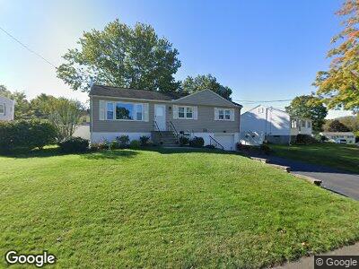
126 Kaye Rd West Haven, CT 06516
West Shore NeighborhoodEstimated Value: $329,385 - $413,000
3
Beds
1
Bath
1,104
Sq Ft
$335/Sq Ft
Est. Value
About This Home
This home is located at 126 Kaye Rd, West Haven, CT 06516 and is currently estimated at $369,346, approximately $334 per square foot. 126 Kaye Rd is a home located in New Haven County with nearby schools including Carrigan 5/6 Intermediate School, Harry M. Bailey Middle School, and West Haven High School.
Ownership History
Date
Name
Owned For
Owner Type
Purchase Details
Closed on
Jul 31, 2001
Sold by
Egan Arthur T and Egan Priscilla K
Bought by
Fertman Steven D and Fertman Gwyneth E
Current Estimated Value
Purchase Details
Closed on
Jul 26, 1993
Sold by
Davis Howard A
Bought by
Egan Arthur T and Egan Priscilla K
Create a Home Valuation Report for This Property
The Home Valuation Report is an in-depth analysis detailing your home's value as well as a comparison with similar homes in the area
Home Values in the Area
Average Home Value in this Area
Purchase History
| Date | Buyer | Sale Price | Title Company |
|---|---|---|---|
| Fertman Steven D | $163,000 | -- | |
| Egan Arthur T | $127,000 | -- | |
| Fertman Steven D | $163,000 | -- | |
| Egan Arthur T | $127,000 | -- |
Source: Public Records
Mortgage History
| Date | Status | Borrower | Loan Amount |
|---|---|---|---|
| Open | Egan Arthur T | $50,000 | |
| Closed | Egan Arthur T | $31,500 | |
| Open | Egan Arthur T | $160,000 |
Source: Public Records
Tax History Compared to Growth
Tax History
| Year | Tax Paid | Tax Assessment Tax Assessment Total Assessment is a certain percentage of the fair market value that is determined by local assessors to be the total taxable value of land and additions on the property. | Land | Improvement |
|---|---|---|---|---|
| 2024 | $6,419 | $136,990 | $59,150 | $77,840 |
| 2023 | $6,178 | $136,990 | $59,150 | $77,840 |
| 2022 | $6,067 | $136,990 | $59,150 | $77,840 |
| 2021 | $6,067 | $136,990 | $59,150 | $77,840 |
| 2020 | $6,074 | $124,950 | $54,320 | $70,630 |
| 2019 | $5,880 | $124,950 | $54,320 | $70,630 |
| 2018 | $5,796 | $124,950 | $54,320 | $70,630 |
| 2017 | $5,640 | $124,950 | $54,320 | $70,630 |
| 2016 | $5,578 | $124,950 | $54,320 | $70,630 |
| 2015 | $5,625 | $141,050 | $58,660 | $82,390 |
| 2014 | $5,625 | $141,050 | $58,660 | $82,390 |
Source: Public Records
Map
Nearby Homes
- 11 Botte Dr
- 6 Apple Tree Terrace
- 148 Central Ave
- 271 Jones Hill Rd
- 132 Hillside Ave
- 239 Bellevue Ave
- 39 Rockefeller Ave
- 67 Pauline Ave
- 27 Aircraft Rd
- 49 Hillside Ave
- 116 Milton Ave
- 300 Country Hill Dr
- 13 Grand St
- 69 Tyler St
- 51 Easy Rudder Ln
- 63 Contact Dr
- 87 Seaview Ave
- 96 Harding Ave
- 116 Aimes Dr
- 137 Harding Ave