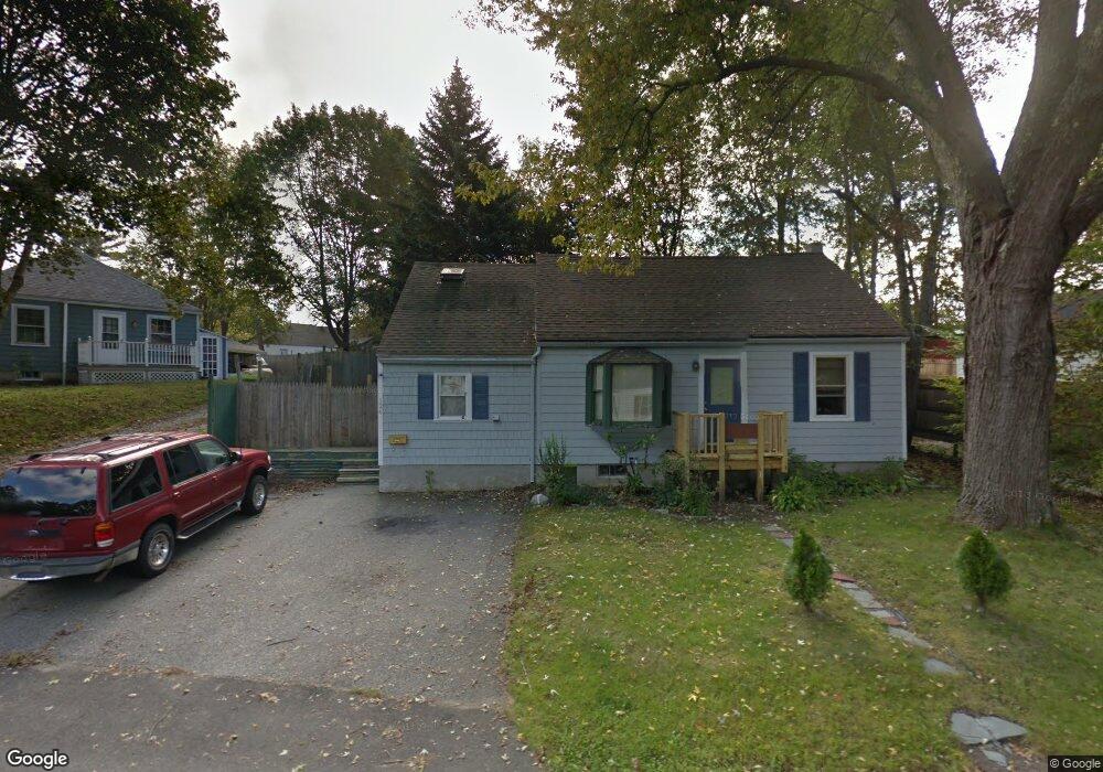
126 Manson Ave Kittery, ME 03904
Estimated Value: $429,929 - $528,000
4
Beds
1
Bath
1,487
Sq Ft
$315/Sq Ft
Est. Value
About This Home
This home is located at 126 Manson Ave, Kittery, ME 03904 and is currently estimated at $468,732, approximately $315 per square foot. 126 Manson Ave is a home located in York County with nearby schools including Shapleigh School, Horace Mitchell Primary School, and Robert W Traip Academy.
Ownership History
Date
Name
Owned For
Owner Type
Purchase Details
Closed on
Jul 23, 2025
Sold by
Shepard Richard M and Simpson Colin
Bought by
Shepard Richard M and Simpson Colin
Current Estimated Value
Purchase Details
Closed on
Jan 22, 2009
Sold by
Department Of Housing & Urban Dev
Bought by
Gallant Bette Jean
Home Financials for this Owner
Home Financials are based on the most recent Mortgage that was taken out on this home.
Original Mortgage
$89,600
Interest Rate
5.51%
Mortgage Type
Purchase Money Mortgage
Create a Home Valuation Report for This Property
The Home Valuation Report is an in-depth analysis detailing your home's value as well as a comparison with similar homes in the area
Home Values in the Area
Average Home Value in this Area
Purchase History
| Date | Buyer | Sale Price | Title Company |
|---|---|---|---|
| Shepard Richard M | -- | -- | |
| Shepard Richard M | -- | -- | |
| Shepard Richard M | -- | -- | |
| Gallant Bette Jean | $112,000 | -- | |
| Gallant Bette Jean | $112,000 | -- |
Source: Public Records
Mortgage History
| Date | Status | Borrower | Loan Amount |
|---|---|---|---|
| Previous Owner | Gallant Bette Jean | $89,600 |
Source: Public Records
Tax History Compared to Growth
Tax History
| Year | Tax Paid | Tax Assessment Tax Assessment Total Assessment is a certain percentage of the fair market value that is determined by local assessors to be the total taxable value of land and additions on the property. | Land | Improvement |
|---|---|---|---|---|
| 2024 | $3,639 | $256,300 | $109,700 | $146,600 |
| 2023 | $3,488 | $256,300 | $109,700 | $146,600 |
| 2022 | $3,455 | $256,300 | $109,700 | $146,600 |
| 2021 | $3,332 | $256,300 | $109,700 | $146,600 |
| 2020 | $9,620 | $256,300 | $109,700 | $146,600 |
| 2019 | $3,403 | $169,600 | $57,200 | $112,400 |
| 2018 | $3,576 | $169,600 | $57,200 | $112,400 |
| 2017 | $2,780 | $168,500 | $57,200 | $111,300 |
| 2016 | $2,704 | $168,500 | $57,200 | $111,300 |
| 2015 | $2,640 | $168,500 | $57,200 | $111,300 |
| 2014 | $2,615 | $168,500 | $57,200 | $111,300 |
| 2013 | $2,565 | $168,500 | $57,200 | $111,300 |
Source: Public Records
Map
Nearby Homes
- 12 Gillis Dr Unit 3
- 116 Whipple Rd
- 165 Rogers Rd
- 205 Whipple Rd
- 10-12 Pine St
- 8 Spruce Point Rd
- 100 Shepards Cove Rd Unit F204
- 100 Shepards Cove Rd Unit G204
- 197 State Rd
- 8 Water St Unit 2
- 8 Water St Unit 1
- 122 Haley Rd
- 20 Mendum Ave
- 5 Spinney Way Unit 9
- 35 Badgers Island W Unit 203
- 35 Badgers Island W Unit 301
- 35 Badgers Island W Unit 204
- 35 Badgers Island W Unit 103
- 35 Badgers Island W Unit 102
- 27 Oak Terrace