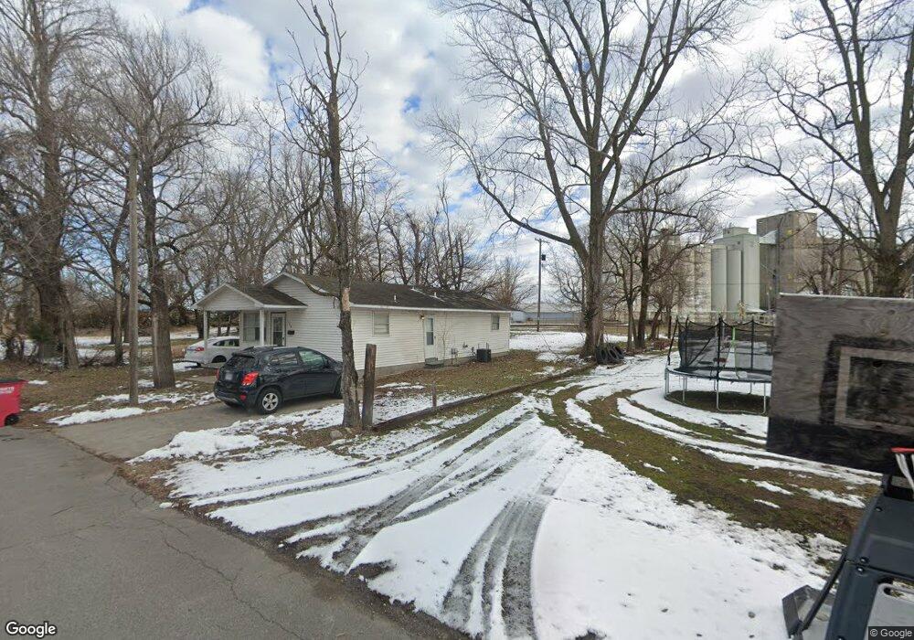
126 N Handy St Sikeston, MO 63801
Estimated Value: $42,000 - $107,000
--
Bed
--
Bath
1,134
Sq Ft
$67/Sq Ft
Est. Value
About This Home
This home is located at 126 N Handy St, Sikeston, MO 63801 and is currently estimated at $76,372, approximately $67 per square foot. 126 N Handy St is a home with nearby schools including Sikeston Senior High School, St. Francis Xavier School, and The Christian Academy.
Ownership History
Date
Name
Owned For
Owner Type
Purchase Details
Closed on
Apr 29, 2022
Sold by
Land Clearance For Redevelopment Authori
Bought by
Blissett Carisa and Winfield Michael
Current Estimated Value
Purchase Details
Closed on
Oct 1, 2021
Sold by
Oakes Sharai
Bought by
City Of Sikeston Land Clearance For Rede
Purchase Details
Closed on
Aug 24, 2020
Sold by
Oakes Junior and Oakes Sharai
Bought by
City Of Sikeston Land Clearance For Rede
Purchase Details
Closed on
May 28, 2013
Sold by
Rangel Antnio and Rangel Ronya
Bought by
Oakes Junior and Oakes Sharai
Purchase Details
Closed on
Apr 14, 2008
Sold by
Martinez Merced Lara and Lara Juan Manuel Antonia
Bought by
Rangel Antonia R and Rangel Tonya J
Create a Home Valuation Report for This Property
The Home Valuation Report is an in-depth analysis detailing your home's value as well as a comparison with similar homes in the area
Home Values in the Area
Average Home Value in this Area
Purchase History
| Date | Buyer | Sale Price | Title Company |
|---|---|---|---|
| Blissett Carisa | -- | -- | |
| City Of Sikeston Land Clearance For Rede | -- | None Available | |
| City Of Sikeston Land Clearance For Rede | -- | None Available | |
| Land Clearance For Redevelopment Authori | $1,095 | None Available | |
| Oakes Junior | -- | -- | |
| Rangel Antonia R | -- | -- |
Source: Public Records
Tax History Compared to Growth
Tax History
| Year | Tax Paid | Tax Assessment Tax Assessment Total Assessment is a certain percentage of the fair market value that is determined by local assessors to be the total taxable value of land and additions on the property. | Land | Improvement |
|---|---|---|---|---|
| 2025 | $10 | $220 | $0 | $0 |
| 2024 | $10 | $220 | $0 | $0 |
| 2023 | $101 | $220 | $0 | $0 |
| 2022 | $101 | $220 | $0 | $0 |
| 2021 | $101 | $0 | $0 | $0 |
| 2020 | $101 | $220 | $0 | $0 |
| 2019 | -- | $2,240 | $0 | $0 |
| 2018 | -- | $2,240 | $0 | $0 |
| 2017 | -- | $2,240 | $0 | $0 |
| 2014 | -- | $2,220 | $0 | $0 |
| 2011 | -- | $2,200 | $0 | $0 |
Source: Public Records
Map
Nearby Homes
- 723 Kendall St
- 406 W Gladys St
- 114 W North St
- 848 Agnes St
- 102 Ruth St
- 325 Daniel St
- 203 N Kingshighway St
- 849 William St
- 512 S New Madrid St
- 119 William St
- 115 William St
- 417 S Kingshighway St
- 520 Coleman St
- 1140 Ruth St
- 408 Carroll St
- 511 S Kingshighway St
- 202 E Woodlawn Ave
- 511 Clayton Ave
- 420 Malcolm Ave
- 312 Tanner St