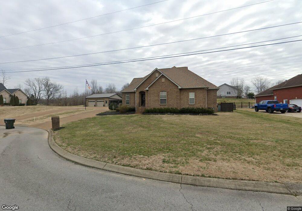
126 Tison Ln Cottontown, TN 37048
Estimated Value: $581,109 - $728,000
--
Bed
4
Baths
2,788
Sq Ft
$236/Sq Ft
Est. Value
About This Home
This home is located at 126 Tison Ln, Cottontown, TN 37048 and is currently estimated at $657,777, approximately $235 per square foot. 126 Tison Ln is a home located in Sumner County with nearby schools including Harold B. Williams Elementary School, White House Middle School, and White House High School.
Ownership History
Date
Name
Owned For
Owner Type
Purchase Details
Closed on
Oct 18, 2007
Sold by
Westerbeck Corp
Bought by
Harris Patricia and Harris John Kevin
Current Estimated Value
Home Financials for this Owner
Home Financials are based on the most recent Mortgage that was taken out on this home.
Original Mortgage
$218,320
Outstanding Balance
$137,433
Interest Rate
6.37%
Mortgage Type
Unknown
Estimated Equity
$520,344
Purchase Details
Closed on
Jun 11, 2007
Sold by
Brinkley James W and Brinkley Elaine
Bought by
Westerbeck Corp
Create a Home Valuation Report for This Property
The Home Valuation Report is an in-depth analysis detailing your home's value as well as a comparison with similar homes in the area
Home Values in the Area
Average Home Value in this Area
Purchase History
| Date | Buyer | Sale Price | Title Company |
|---|---|---|---|
| Harris Patricia | $272,900 | Forsythe Title & Escrow Svcs | |
| Westerbeck Corp | $35,000 | Forsythe Title & Escrow Svcs |
Source: Public Records
Mortgage History
| Date | Status | Borrower | Loan Amount |
|---|---|---|---|
| Open | Harris Patricia | $218,320 |
Source: Public Records
Tax History Compared to Growth
Tax History
| Year | Tax Paid | Tax Assessment Tax Assessment Total Assessment is a certain percentage of the fair market value that is determined by local assessors to be the total taxable value of land and additions on the property. | Land | Improvement |
|---|---|---|---|---|
| 2024 | $2,274 | $160,000 | $20,000 | $140,000 |
| 2023 | $4,204 | $117,150 | $15,350 | $101,800 |
| 2022 | $4,157 | $117,150 | $15,350 | $101,800 |
| 2021 | $3,672 | $103,500 | $15,350 | $88,150 |
| 2020 | $3,413 | $103,500 | $15,350 | $88,150 |
| 2019 | $3,413 | $0 | $0 | $0 |
| 2018 | $2,479 | $0 | $0 | $0 |
| 2017 | $2,479 | $0 | $0 | $0 |
| 2016 | $1,661 | $0 | $0 | $0 |
| 2015 | -- | $0 | $0 | $0 |
| 2014 | -- | $0 | $0 | $0 |
Source: Public Records
Map
Nearby Homes
- 231 S Palmers Chapel Rd
- 107 Ben Albert Rd
- 544 Kingwood Ln
- 540 Kingwood Ln
- 556 Kingwood Ln
- 528 Kingwood Ln
- 520 Kingwood Ln
- 521 Kingwood Ln
- 737 Brownlow Rd
- 813 Tanager Ct
- 809 Tanager Ct
- 517 Kingwood Ln
- 604 Silver Trace
- 612 Silver Trace
- 616 Silver Trace
- Cary Plan at Springbrook Reserve
- Hampton Plan at Springbrook Reserve
- Graham Plan at Springbrook Reserve
- Hawthorn Plan at Springbrook Reserve
- Burton Plan at Springbrook Reserve
- 128 Tison Ln
- 122 Tison Ln
- 118 Tison Ln
- 123 Tison Ln
- 130 Tison Ln
- 114 Tison Ln
- 131 Tison Ln Unit 130131
- 335 B S Palmers Chapel
- 117 Tison Ln
- 335 S Palmers Chapel Rd
- 335 S Palmers Chapel Rd
- 335 S Palmers Chapel Rd
- 335 S Palmers Chapel Rd Unit B
- 335 S Palmers Chapel Rd Unit B
- 112 Tison Ln
- 106 Tison Ln
- 107 Tison Ln
- 204 Morgan Trace Ct
- 209 Morgan Trace
- 212 Morgan Trace