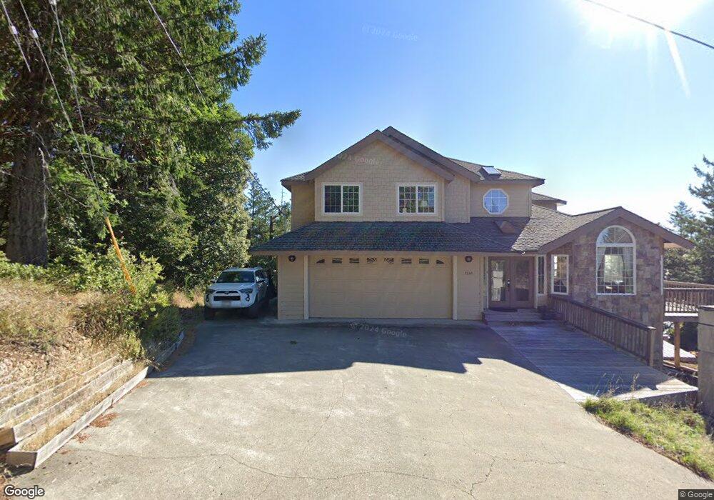
1261 Toth Rd Whitethorn, CA 95589
Estimated Value: $487,000 - $553,000
2
Beds
3
Baths
2,452
Sq Ft
$212/Sq Ft
Est. Value
About This Home
This home is located at 1261 Toth Rd, Whitethorn, CA 95589 and is currently estimated at $519,256, approximately $211 per square foot. 1261 Toth Rd is a home located in Humboldt County.
Ownership History
Date
Name
Owned For
Owner Type
Purchase Details
Closed on
May 3, 2018
Sold by
Malinowski William W
Bought by
Malinowski William W
Current Estimated Value
Home Financials for this Owner
Home Financials are based on the most recent Mortgage that was taken out on this home.
Original Mortgage
$335,000
Outstanding Balance
$288,778
Interest Rate
4.45%
Mortgage Type
New Conventional
Estimated Equity
$230,478
Purchase Details
Closed on
Jun 16, 2006
Sold by
Malinowski Teresa L
Bought by
Malinowski William W
Purchase Details
Closed on
Apr 19, 2000
Sold by
Rafferty Steven J and Rafferty Gayle A
Bought by
Malinowski William W and Malinowski Teresa L
Home Financials for this Owner
Home Financials are based on the most recent Mortgage that was taken out on this home.
Original Mortgage
$31,500
Interest Rate
8.18%
Mortgage Type
Seller Take Back
Create a Home Valuation Report for This Property
The Home Valuation Report is an in-depth analysis detailing your home's value as well as a comparison with similar homes in the area
Home Values in the Area
Average Home Value in this Area
Purchase History
| Date | Buyer | Sale Price | Title Company |
|---|---|---|---|
| Malinowski William W | -- | Fidelity National Title Comp | |
| Malinowski William W | -- | None Available | |
| Malinowski William W | $35,000 | First American Title |
Source: Public Records
Mortgage History
| Date | Status | Borrower | Loan Amount |
|---|---|---|---|
| Open | Malinowski William W | $335,000 | |
| Closed | Malinowski William W | $31,500 |
Source: Public Records
Tax History
| Year | Tax Paid | Tax Assessment Tax Assessment Total Assessment is a certain percentage of the fair market value that is determined by local assessors to be the total taxable value of land and additions on the property. | Land | Improvement |
|---|---|---|---|---|
| 2025 | $3,948 | $352,012 | $52,854 | $299,158 |
| 2024 | $3,948 | $345,111 | $51,818 | $293,293 |
| 2023 | $3,962 | $338,345 | $50,802 | $287,543 |
| 2022 | $3,902 | $331,711 | $49,806 | $281,905 |
| 2021 | $3,760 | $325,208 | $48,830 | $276,378 |
| 2020 | $3,781 | $321,875 | $48,330 | $273,545 |
| 2019 | $3,690 | $315,565 | $47,383 | $268,182 |
| 2018 | $3,629 | $309,378 | $46,454 | $262,924 |
| 2017 | $3,463 | $303,313 | $45,544 | $257,769 |
| 2016 | $3,441 | $297,366 | $44,651 | $252,715 |
| 2015 | $3,348 | $286,132 | $43,981 | $242,151 |
| 2014 | $2,950 | $249,394 | $43,120 | $206,274 |
Source: Public Records
Map
Nearby Homes
- 1199 Toth Rd
- 43 & 61 Wood Ct
- 1453 Toth Rd
- 914 Blueridge Rd Unit 13
- 25 Seneca Ct Unit 10
- 2685 Toth Rd Unit 20 Block 193
- 181 & 165 Ranger Ct
- 55 Pepperwood Dr
- 34 Vance Rd
- 67 Atchison Ct
- 129 Vance Rd
- 112 Willow Glen Rd
- 0 Willow Glen Rd
- 1071 Hillside Dr
- 463 Cook Rd
- 171 Cook Rd
- 127 Cook Rd
- 65 Carson Ct
- 85 Carson Ct
- 921 Hillside Dr
Your Personal Tour Guide
Ask me questions while you tour the home.