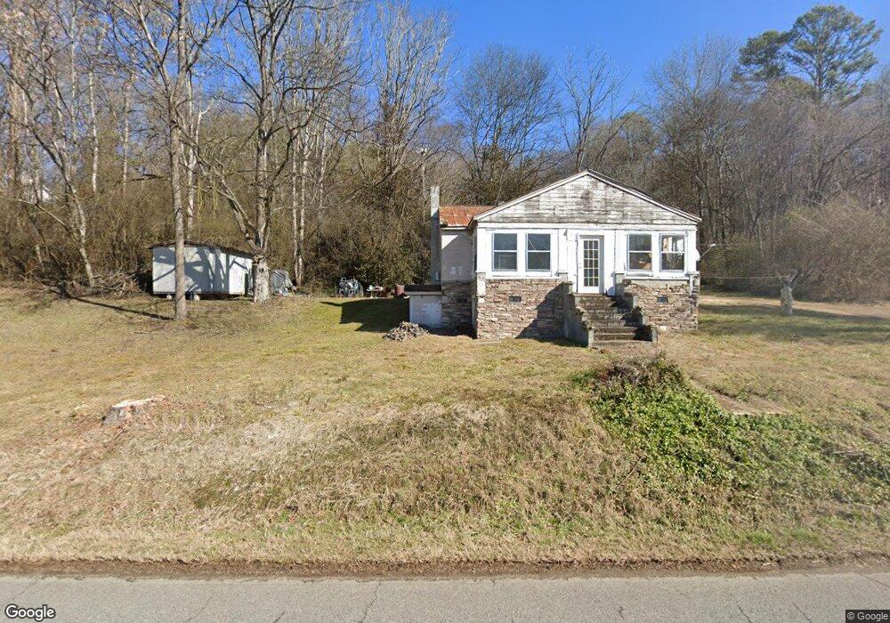
12631 Fork Creek Rd Philadelphia, TN 37846
Estimated Value: $105,000 - $679,000
--
Bed
1
Bath
952
Sq Ft
$288/Sq Ft
Est. Value
About This Home
This home is located at 12631 Fork Creek Rd, Philadelphia, TN 37846 and is currently estimated at $273,838, approximately $287 per square foot. 12631 Fork Creek Rd is a home located in Loudon County with nearby schools including Loudon High School.
Ownership History
Date
Name
Owned For
Owner Type
Purchase Details
Closed on
Oct 23, 2013
Sold by
Dunlap Kristi
Bought by
White Jo Ann
Current Estimated Value
Purchase Details
Closed on
Jun 5, 2008
Sold by
Allan White
Bought by
Kristi Dunlap
Purchase Details
Closed on
May 22, 2000
Sold by
David Hammontree
Bought by
Keith Eisberg
Purchase Details
Closed on
Jan 19, 2000
Sold by
Hammontree George M
Bought by
David Hammontree
Purchase Details
Closed on
Nov 16, 1998
Bought by
Michael Tunkel
Purchase Details
Closed on
Nov 9, 1992
Bought by
White Allan and White Jo Ann
Create a Home Valuation Report for This Property
The Home Valuation Report is an in-depth analysis detailing your home's value as well as a comparison with similar homes in the area
Home Values in the Area
Average Home Value in this Area
Purchase History
| Date | Buyer | Sale Price | Title Company |
|---|---|---|---|
| White Jo Ann | -- | -- | |
| Kristi Dunlap | $25,600 | -- | |
| Keith Eisberg | $322,800 | -- | |
| David Hammontree | $15,000 | -- | |
| Michael Tunkel | $16,830 | -- | |
| White Allan | $16,200 | -- |
Source: Public Records
Tax History Compared to Growth
Tax History
| Year | Tax Paid | Tax Assessment Tax Assessment Total Assessment is a certain percentage of the fair market value that is determined by local assessors to be the total taxable value of land and additions on the property. | Land | Improvement |
|---|---|---|---|---|
| 2025 | $488 | $27,575 | $9,175 | $18,400 |
| 2023 | $419 | $27,575 | $0 | $0 |
| 2022 | $419 | $27,575 | $9,175 | $18,400 |
| 2021 | $419 | $27,575 | $9,175 | $18,400 |
| 2020 | $343 | $27,575 | $9,175 | $18,400 |
| 2019 | $343 | $19,025 | $9,175 | $9,850 |
| 2018 | $343 | $19,025 | $9,175 | $9,850 |
| 2017 | $343 | $19,025 | $9,175 | $9,850 |
| 2016 | $283 | $15,200 | $6,725 | $8,475 |
| 2015 | $283 | $15,200 | $6,725 | $8,475 |
| 2014 | $283 | $15,200 | $6,725 | $8,475 |
Source: Public Records
Map
Nearby Homes
- 960 Corinth Church Rd
- 4660 Corinth Church Rd
- 200 Gardner Rd
- 850 Grimes Rd
- 261 Garden Ln
- 22920 Steekee Rd
- 310 Moat Sewell Rd
- 399 Watkins Rd E
- 612 Caldwell Rd
- 0 Sunnyside Rd Unit 1316779
- 149 Moat Sewell Rd
- 300 Willington Place
- 700 Willington Place
- 102 Cabin Cir
- 5816 Caldwell Rd
- 5817 Caldwell Rd
- 487 Julip Ln
- 495 Allison Town Rd
- 3101 Watson Rd
- 928 Kline Dr
- 11875 Fork Creek Rd
- 12803 Fork Creek Rd
- 11817 Fork Creek Rd
- 12945 Fork Creek Rd
- 9829 Calloway Rd
- 11591 Fork Creek Rd
- 9521 Calloway Rd
- 1400 Millers Cove Ln
- 12650 Fork Creek Rd
- 9300 Calloway Rd
- 9180 Calloway Rd
- 13253 Fork Creek Rd
- 9000 Calloway Rd
- 9000 Calloway Rd
- 10705 Fork Creek Rd
- 0 Calloway Rd
- 1338 Millers Cove Ln
- 8130 Calloway Rd
- 1337 Millers Cove Ln
- 8130 Calloway Rd