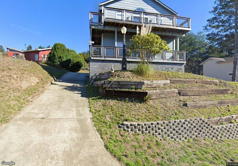
1264 Upper Pacific Dr Whitethorn, CA 95589
Estimated Value: $351,000 - $598,000
Studio
--
Bath
2,144
Sq Ft
$213/Sq Ft
Est. Value
About This Home
This home is located at 1264 Upper Pacific Dr, Whitethorn, CA 95589 and is currently estimated at $456,657, approximately $212 per square foot. 1264 Upper Pacific Dr is a home located in Humboldt County.
Ownership History
Date
Name
Owned For
Owner Type
Purchase Details
Closed on
Sep 22, 2023
Sold by
Mccurry Leslie K
Bought by
Leslie Mccurry Living Trust and Mccurry
Current Estimated Value
Purchase Details
Closed on
Sep 21, 2023
Sold by
Mccurry Leslie K
Bought by
Leslie Mccurry Living Trust and Mccurry
Purchase Details
Closed on
Mar 24, 1997
Sold by
Mccurry Walter W and Mccurry Sandra L
Bought by
Walter W & Sandra L Mccurry Family Trust
Create a Home Valuation Report for This Property
The Home Valuation Report is an in-depth analysis detailing your home's value as well as a comparison with similar homes in the area
Home Values in the Area
Average Home Value in this Area
Purchase History
| Date | Buyer | Sale Price | Title Company |
|---|---|---|---|
| Leslie Mccurry Living Trust | -- | None Listed On Document | |
| Mckinley Family 2014 Revocable Trust | -- | None Listed On Document | |
| Leslie Mccurry Living Trust | -- | None Listed On Document | |
| Mckinley Family 2014 Revocable Trust | -- | None Listed On Document | |
| Mccurry Leslie K | -- | None Listed On Document | |
| Walter W & Sandra L Mccurry Family Trust | -- | -- |
Source: Public Records
Tax History
| Year | Tax Paid | Tax Assessment Tax Assessment Total Assessment is a certain percentage of the fair market value that is determined by local assessors to be the total taxable value of land and additions on the property. | Land | Improvement |
|---|---|---|---|---|
| 2025 | $2,680 | $224,022 | $50,494 | $173,528 |
| 2024 | $2,680 | $219,630 | $49,504 | $170,126 |
| 2023 | $2,690 | $215,325 | $48,534 | $166,791 |
| 2022 | $2,652 | $211,104 | $47,583 | $163,521 |
| 2021 | $2,561 | $206,965 | $46,650 | $160,315 |
| 2020 | $2,575 | $204,844 | $46,172 | $158,672 |
| 2019 | $2,517 | $200,828 | $45,267 | $155,561 |
| 2018 | $2,478 | $196,891 | $44,380 | $152,511 |
| 2017 | $2,260 | $193,031 | $43,510 | $149,521 |
| 2016 | $2,246 | $189,247 | $42,657 | $146,590 |
| 2015 | $2,234 | $186,406 | $42,017 | $144,389 |
| 2014 | $2,168 | $182,755 | $41,194 | $141,561 |
Source: Public Records
Map
Nearby Homes
- 1298 Upper Pacific Dr
- 1284 Upper Pacific Dr
- 1237 Upper Pacific Dr
- 20 Seafoam Rd
- 30 Seafoam Rd
- 32 Seafoam Rd
- 314 Sea View Rd
- 1330 Upper Pacific Dr
- 4 Spruce Ct
- 134 Spruce Rd
- 4 Seafoam Rd
- 72 Spruce Rd
- 18 Spruce Ct
- 130 McMain Ct
- 0 Spruce Ct
- 20 Spruce Ct
- 45 Seafoam Rd
- 1312 Upper Pacific Dr
- 1312 -1330 Upper Pacific Dr
- 1227 Upper Pacific Dr
Your Personal Tour Guide
Ask me questions while you tour the home.