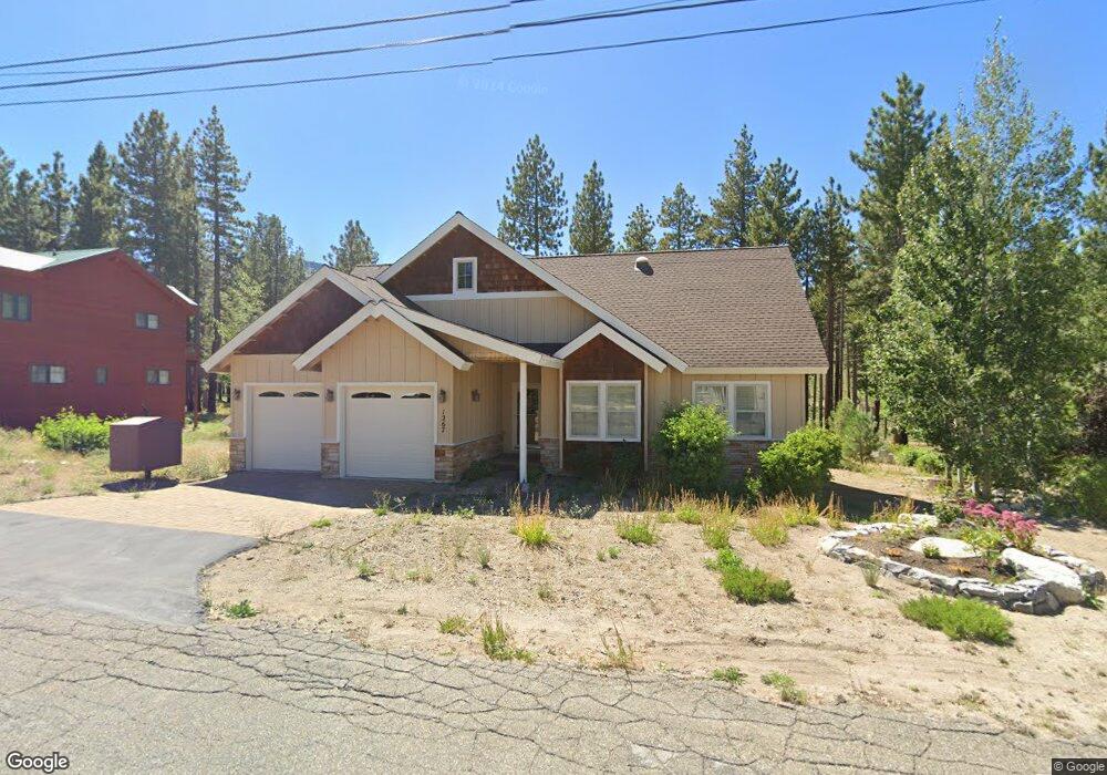
1267 Pyramid Cir South Lake Tahoe, CA 96150
Estimated Value: $635,000 - $802,000
3
Beds
2
Baths
1,499
Sq Ft
$474/Sq Ft
Est. Value
About This Home
This home is located at 1267 Pyramid Cir, South Lake Tahoe, CA 96150 and is currently estimated at $710,989, approximately $474 per square foot. 1267 Pyramid Cir is a home located in El Dorado County with nearby schools including Tahoe Valley Elementary School, South Tahoe Middle School, and South Tahoe High School.
Ownership History
Date
Name
Owned For
Owner Type
Purchase Details
Closed on
Jul 20, 2012
Sold by
Papachristos Zacharias G and Papachristos Patricia L
Bought by
Papachristos Zack G and Papachristos Patricia L
Current Estimated Value
Purchase Details
Closed on
Jan 26, 2007
Sold by
Papachristos Zacharias G
Bought by
Papachristos Zacharias G and Papachristos Patricia L
Purchase Details
Closed on
Jul 19, 2006
Sold by
Papachristos Zacharias G and Papachristos Patricia L
Bought by
Papachristos Zacharias G
Create a Home Valuation Report for This Property
The Home Valuation Report is an in-depth analysis detailing your home's value as well as a comparison with similar homes in the area
Home Values in the Area
Average Home Value in this Area
Purchase History
| Date | Buyer | Sale Price | Title Company |
|---|---|---|---|
| Papachristos Zack G | -- | None Available | |
| Papachristos Zacharias G | -- | None Available | |
| Papachristos Zacharias G | -- | None Available |
Source: Public Records
Tax History Compared to Growth
Tax History
| Year | Tax Paid | Tax Assessment Tax Assessment Total Assessment is a certain percentage of the fair market value that is determined by local assessors to be the total taxable value of land and additions on the property. | Land | Improvement |
|---|---|---|---|---|
| 2025 | $2,879 | $265,707 | $35,673 | $230,034 |
| 2024 | $2,879 | $260,498 | $34,974 | $225,524 |
| 2023 | $2,830 | $255,391 | $34,289 | $221,102 |
| 2022 | $2,802 | $250,384 | $33,617 | $216,767 |
| 2021 | $2,757 | $245,475 | $32,958 | $212,517 |
| 2020 | $2,077 | $182,868 | $13,435 | $169,433 |
| 2019 | $2,068 | $179,283 | $13,172 | $166,111 |
| 2018 | $2,023 | $175,768 | $12,914 | $162,854 |
| 2017 | $1,992 | $172,322 | $12,661 | $159,661 |
| 2016 | $1,953 | $168,944 | $12,413 | $156,531 |
| 2015 | $1,856 | $166,409 | $12,228 | $154,181 |
| 2014 | $1,856 | $163,152 | $11,990 | $151,162 |
Source: Public Records
Map
Nearby Homes
- 715 Shoshone St
- 511 Little Mountain Ln
- 577 Cochise Cir
- 1581 Estate Ct
- 1836 Grizzly Mountain Dr
- 928 Kiowa Dr
- 712 Seneca Dr
- 742 Kiowa Dr Unit 22
- 831 Mule Deer Cir
- 1741 Delaware St
- 1774 Delaware St
- 1820 Nez Perce Dr
- 1828 Toppewetah St
- 1832 Nez Perce Dr
- 1879 Pima St
- 1885 Mewuk Dr
- 1894 Normuk St
- 1871 Normuk St
- 1966 Nez Perce Dr
- 1889 Normuk St
- 1261 Pyramid Cir
- 1281 Pyramid Cir
- 1266 Pyramid Cir
- 1260 Pyramid Cir
- 1251 Pyramid Cir
- 1280 Pyramid Cir
- 1248 Pyramid Cir
- 1285 Pyramid Cir Unit Ci
- 1247 Pyramid Cir
- 1508 Snow Mountain Dr
- 1516 Snow Mountain Dr
- 1504 Snow Mountain Dr
- 1291 Pyramid Cir
- 1236 Pyramid Cir
- 1500 Snow Mountain Dr
- 1520 Snow Mountain Dr
- 1381 Cliff Rd
- 1371 Cliff Rd
- 1237 Pyramid Cir
- 1507 Snow Mountain Dr