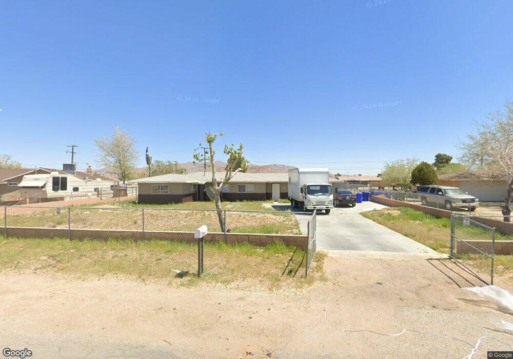
12675 Tonikan Rd Apple Valley, CA 92308
High Desert NeighborhoodEstimated Value: $314,521 - $384,000
3
Beds
2
Baths
1,274
Sq Ft
$277/Sq Ft
Est. Value
About This Home
This home is located at 12675 Tonikan Rd, Apple Valley, CA 92308 and is currently estimated at $353,380, approximately $277 per square foot. 12675 Tonikan Rd is a home located in San Bernardino County with nearby schools including Sandia Elementary School and Apple Valley High School.
Ownership History
Date
Name
Owned For
Owner Type
Purchase Details
Closed on
Mar 31, 2009
Sold by
Wells Fargo Bank Na
Bought by
Perez Jose J and Perez Maria R
Current Estimated Value
Purchase Details
Closed on
Sep 5, 2008
Sold by
Harris Robert
Bought by
Wells Fargo Bank Na and Securitized Asset Back Receivables Llc T
Purchase Details
Closed on
Mar 24, 2006
Sold by
The Broker Connection Llc
Bought by
Harris Robert and Pouncil Edna
Home Financials for this Owner
Home Financials are based on the most recent Mortgage that was taken out on this home.
Original Mortgage
$207,188
Interest Rate
7.07%
Mortgage Type
Purchase Money Mortgage
Purchase Details
Closed on
Sep 14, 2005
Sold by
Armstrong Samuel
Bought by
The Broker Connection Llc and The Tonikan Road Title Trust
Purchase Details
Closed on
Dec 3, 2003
Sold by
Armstrong Aaron Scott
Bought by
Armstrong Samuel and Armstrong Barbara J
Purchase Details
Closed on
Dec 29, 2001
Sold by
Creative Investment Network Inc
Bought by
Armstrong Aaron S
Purchase Details
Closed on
Mar 10, 2000
Sold by
Bank Of New York
Bought by
Creative Investment Network Inc
Home Financials for this Owner
Home Financials are based on the most recent Mortgage that was taken out on this home.
Original Mortgage
$58,000
Interest Rate
8.38%
Purchase Details
Closed on
Sep 20, 1999
Sold by
Lamphere Geraldine A
Bought by
Cwmbs Inc and Countrywide Mtg Conduit Inc
Purchase Details
Closed on
Dec 30, 1997
Sold by
Lamphere Galen T
Bought by
Lamphere Geraldine A
Home Financials for this Owner
Home Financials are based on the most recent Mortgage that was taken out on this home.
Original Mortgage
$58,500
Interest Rate
7.16%
Purchase Details
Closed on
Sep 3, 1997
Sold by
Brungton Bonnie K
Bought by
Lamphere Geraldine A
Create a Home Valuation Report for This Property
The Home Valuation Report is an in-depth analysis detailing your home's value as well as a comparison with similar homes in the area
Home Values in the Area
Average Home Value in this Area
Purchase History
| Date | Buyer | Sale Price | Title Company |
|---|---|---|---|
| Perez Jose J | $40,500 | Commerce Title Company | |
| Wells Fargo Bank Na | $152,395 | Accommodation | |
| Harris Robert | $259,000 | Chicago Title Company | |
| The Broker Connection Llc | -- | Chicago Title Company | |
| Armstrong Samuel | -- | -- | |
| Armstrong Aaron S | $10,000 | -- | |
| Creative Investment Network Inc | $45,000 | United Title | |
| Cwmbs Inc | $57,500 | Landsafe Title | |
| Lamphere Geraldine A | -- | Commonwealth Land Title Co | |
| Lamphere Geraldine A | -- | -- |
Source: Public Records
Mortgage History
| Date | Status | Borrower | Loan Amount |
|---|---|---|---|
| Previous Owner | Harris Robert | $207,188 | |
| Previous Owner | Creative Investment Network Inc | $58,000 | |
| Previous Owner | Lamphere Geraldine A | $58,500 | |
| Closed | Lamphere Geraldine A | $57,200 |
Source: Public Records
Tax History
| Year | Tax Paid | Tax Assessment Tax Assessment Total Assessment is a certain percentage of the fair market value that is determined by local assessors to be the total taxable value of land and additions on the property. | Land | Improvement |
|---|---|---|---|---|
| 2025 | $738 | $52,154 | $12,878 | $39,276 |
| 2024 | $718 | $51,131 | $12,625 | $38,506 |
| 2023 | $710 | $50,128 | $12,377 | $37,751 |
| 2022 | $699 | $49,145 | $12,134 | $37,011 |
| 2021 | $683 | $48,181 | $11,896 | $36,285 |
| 2020 | $674 | $47,687 | $11,774 | $35,913 |
| 2019 | $662 | $46,752 | $11,543 | $35,209 |
| 2018 | $646 | $45,836 | $11,317 | $34,519 |
| 2017 | $637 | $44,937 | $11,095 | $33,842 |
| 2016 | $568 | $44,055 | $10,877 | $33,178 |
| 2015 | $559 | $43,394 | $10,714 | $32,680 |
| 2014 | $552 | $42,544 | $10,504 | $32,040 |
Source: Public Records
Map
Nearby Homes
- 10647 Central Rd
- 22241 Nisqually Rd Unit 118
- 22241 Nisqually Rd Unit 169
- 22241 Nisqually Rd Unit 143
- 22241 Nisqually Rd
- 22241 Nisqually Rd Unit 20
- 22241 Nisqually Rd Unit 124
- 22665 Little Beaver Rd
- 22186 Pahute Rd
- 22517 Ojai Rd
- 22225 Kayenta Rd
- 12442 Quinnault Rd
- 22020 Nisqually Rd Unit 3
- 22020 Nisqually Rd Unit 49
- 22330 Miramot Rd
- 22035 Pahute Rd
- 21985 Maumee Rd
- 0 Pahute Rd Unit HD25164188
- 0 Pahute Rd Unit HD26005960
- 22449 Ottawa Rd
- 12659 Tonikan Rd
- 22455 Little Beaver Rd
- 12676 Central Rd
- 12660 Central Rd
- 12645 Tonikan Rd
- 22479 Little Beaver Rd
- 22423 Little Beaver Rd
- 12658 Tonikan Rd
- 22474 Little Beaver Rd
- 12646 Central Rd
- 12629 Tonikan Rd
- 22405 Little Beaver Rd
- 22406 Lone Eagle Rd
- 12630 Central Rd
- 11125 Central Rd
- 6146 Central Rd
- 12472 Central Rd
- 20 Central Rd
- 12615 Tonikan Rd
- 22393 Little Beaver Rd
Your Personal Tour Guide
Ask me questions while you tour the home.