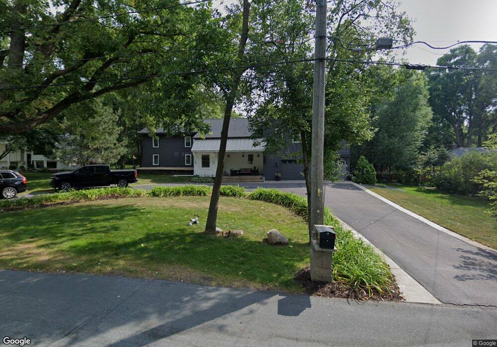
1268 Amble Rd New Brighton, MN 55112
Estimated Value: $719,131 - $858,000
4
Beds
4
Baths
3,992
Sq Ft
$195/Sq Ft
Est. Value
About This Home
This home is located at 1268 Amble Rd, New Brighton, MN 55112 and is currently estimated at $778,283, approximately $194 per square foot. 1268 Amble Rd is a home located in Ramsey County with nearby schools including Island Lake Elementary School, Chippewa Middle School, and Mounds View Senior High School.
Ownership History
Date
Name
Owned For
Owner Type
Purchase Details
Closed on
Apr 15, 2022
Sold by
Osgood Chad and Osgood Christine
Bought by
Anderson Lars
Current Estimated Value
Home Financials for this Owner
Home Financials are based on the most recent Mortgage that was taken out on this home.
Original Mortgage
$574,800
Outstanding Balance
$537,054
Interest Rate
3.76%
Mortgage Type
New Conventional
Estimated Equity
$241,229
Purchase Details
Closed on
Apr 14, 2022
Sold by
Osgood Chad T and Osgood Christine B
Bought by
Anderson Lars
Home Financials for this Owner
Home Financials are based on the most recent Mortgage that was taken out on this home.
Original Mortgage
$574,800
Outstanding Balance
$537,054
Interest Rate
3.76%
Mortgage Type
New Conventional
Estimated Equity
$241,229
Create a Home Valuation Report for This Property
The Home Valuation Report is an in-depth analysis detailing your home's value as well as a comparison with similar homes in the area
Home Values in the Area
Average Home Value in this Area
Purchase History
| Date | Buyer | Sale Price | Title Company |
|---|---|---|---|
| Anderson Lars | $718,500 | -- | |
| Anderson Lars | $718,500 | None Listed On Document |
Source: Public Records
Mortgage History
| Date | Status | Borrower | Loan Amount |
|---|---|---|---|
| Open | Anderson Lars | $574,800 | |
| Closed | Anderson Lars | $574,800 |
Source: Public Records
Tax History Compared to Growth
Tax History
| Year | Tax Paid | Tax Assessment Tax Assessment Total Assessment is a certain percentage of the fair market value that is determined by local assessors to be the total taxable value of land and additions on the property. | Land | Improvement |
|---|---|---|---|---|
| 2025 | $7,792 | $661,300 | $146,600 | $514,700 |
| 2023 | $7,792 | $621,000 | $146,600 | $474,400 |
| 2022 | $5,558 | $462,400 | $146,600 | $315,800 |
| 2021 | $6,186 | $411,700 | $146,600 | $265,100 |
| 2020 | $6,570 | $472,000 | $146,600 | $325,400 |
| 2019 | $5,850 | $464,600 | $146,600 | $318,000 |
| 2018 | $6,688 | $439,900 | $146,600 | $293,300 |
| 2017 | $6,010 | $453,400 | $146,600 | $306,800 |
| 2016 | $6,068 | $0 | $0 | $0 |
| 2015 | $5,820 | $389,600 | $146,600 | $243,000 |
| 2014 | $5,690 | $0 | $0 | $0 |
Source: Public Records
Map
Nearby Homes
- 4371 Arden View Ct
- 4387 Arden View Ct
- 1348 Arden View Dr
- 4478 Arden View Ct
- 1091 Westcliff Curve
- 1507 Arden Vista Ct
- 4525 Churchill St
- 4466 Victoria St N
- 1531 Briarknoll Cir
- 4277 Colleen Cir
- 1575 Mcclung Dr
- 4217 Bristol Run
- 4186 Oxford Ct N
- 4237 Sylvia Ln N
- 1675 Brueberry Ln
- 833 Amble Ct
- 4250 Victoria St N
- 970 Monterey Dr
- 955 Monterey Ct N
- 4120 Victoria St N
- 1274 Amble Rd
- 1274 1274 Amble Rd
- 1260 Amble Rd
- 1284 Amble Rd
- 1248 Amble Rd
- 1225 Amble Rd
- 1257 Amble Rd
- 1267 Wyncrest Ct
- 1259 1259 Wyncrest Ct
- 1259 Wyncrest Ct
- 1277 Wyncrest Ct
- 1294 Amble Rd
- 1291 Amble Rd
- 1251 Wyncrest Ct
- 1285 Wyncrest Ct
- 1245 Amble Rd
- 4415 Dellwood St
- XXX Amble Rd
- 4410 Dellwood St
- 1243 Wyncrest Ct