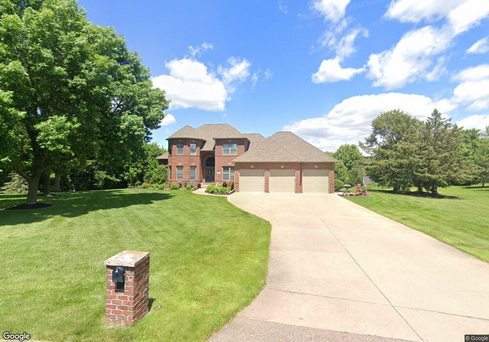
127 127 Red Oak Ct Mankato, MN 56001
Estimated Value: $888,000 - $934,000
5
Beds
4
Baths
5,225
Sq Ft
$176/Sq Ft
Est. Value
About This Home
This home is located at 127 127 Red Oak Ct, Mankato, MN 56001 and is currently estimated at $917,557, approximately $175 per square foot. 127 127 Red Oak Ct is a home located in Blue Earth County with nearby schools including Jefferson Elementary School, Dakota Meadows Middle School, and Mankato West Senior High School.
Ownership History
Date
Name
Owned For
Owner Type
Purchase Details
Closed on
Nov 13, 2025
Sold by
Kruse Michael J and Kruse Jennifer M
Bought by
Simpson Sean Richard and Simpson Mary Mccuskey
Current Estimated Value
Home Financials for this Owner
Home Financials are based on the most recent Mortgage that was taken out on this home.
Original Mortgage
$645,000
Outstanding Balance
$645,000
Interest Rate
6.34%
Mortgage Type
New Conventional
Estimated Equity
$272,557
Purchase Details
Closed on
Aug 17, 2012
Sold by
Wasko Marlin A and Wasko Karen J
Bought by
Kruse Michael J and Kruse Jennifer M
Home Financials for this Owner
Home Financials are based on the most recent Mortgage that was taken out on this home.
Original Mortgage
$417,000
Interest Rate
3.54%
Mortgage Type
New Conventional
Create a Home Valuation Report for This Property
The Home Valuation Report is an in-depth analysis detailing your home's value as well as a comparison with similar homes in the area
Home Values in the Area
Average Home Value in this Area
Purchase History
| Date | Buyer | Sale Price | Title Company |
|---|---|---|---|
| Simpson Sean Richard | $870,000 | Platinum Title | |
| Kruse Michael J | $525,000 | North American Title Company |
Source: Public Records
Mortgage History
| Date | Status | Borrower | Loan Amount |
|---|---|---|---|
| Open | Simpson Sean Richard | $645,000 | |
| Previous Owner | Kruse Michael J | $417,000 |
Source: Public Records
Tax History Compared to Growth
Tax History
| Year | Tax Paid | Tax Assessment Tax Assessment Total Assessment is a certain percentage of the fair market value that is determined by local assessors to be the total taxable value of land and additions on the property. | Land | Improvement |
|---|---|---|---|---|
| 2025 | $7,990 | $817,200 | $101,300 | $715,900 |
| 2024 | $7,990 | $700,900 | $101,300 | $599,600 |
| 2023 | $7,578 | $734,900 | $101,300 | $633,600 |
| 2022 | $7,768 | $676,700 | $101,300 | $575,400 |
| 2021 | $7,598 | $622,100 | $101,300 | $520,800 |
| 2020 | $8,672 | $645,300 | $126,000 | $519,300 |
| 2019 | $6,190 | $645,300 | $126,000 | $519,300 |
| 2018 | $5,792 | $620,900 | $126,000 | $494,900 |
| 2017 | $5,258 | $587,000 | $126,000 | $461,000 |
| 2016 | $4,960 | $564,200 | $126,000 | $438,200 |
| 2015 | $48 | $539,900 | $126,000 | $413,900 |
| 2014 | $5,378 | $544,500 | $126,000 | $418,500 |
Source: Public Records
Map
Nearby Homes
- 27 Capri Dr
- 208 Chancery Ln
- 121 Viking Ct
- 0 Tbd South Brook Way
- 309 Viking Dr
- 108 S Brook Way
- TBD S Brook Way
- 213 Rosewood Dr
- 216 S Brook Cir
- 112 Rosewood Dr Unit 108 Rosewood Drive
- 108 Ella Ct
- 20206 Monks Ave
- 124 Joshua Ct
- TBD Woodridge
- 109 Emily Ln
- 128 Timberwolf Ct
- 436 W Hudson Ave
- 2 A Madison Ave
- 338 James Ave
- 316 Stoltzman Rd
- 124 Red Oak Ct
- 123 Red Oak Ct
- 40 Telemark Dr
- 118 Red Oak Ct
- 119 Red Oak Ct
- 8 Telemark Dr
- Lot 8 Telemark Dr
- 6 Telemark Dr
- Lot 6 Telemark Dr
- 50 Telemark Dr
- 1001 Applewood Ct
- 1003 Applewood Ct
- 1001 1001 Applewood Ct
- 114 Red Oak Ct
- 115 Red Oak Ct
- 1005 Applewood Ct
- 126 Red Oak Dr
- 130 Red Oak Dr
- 20199 Stoltzman Rd
- 60 Telemark Dr