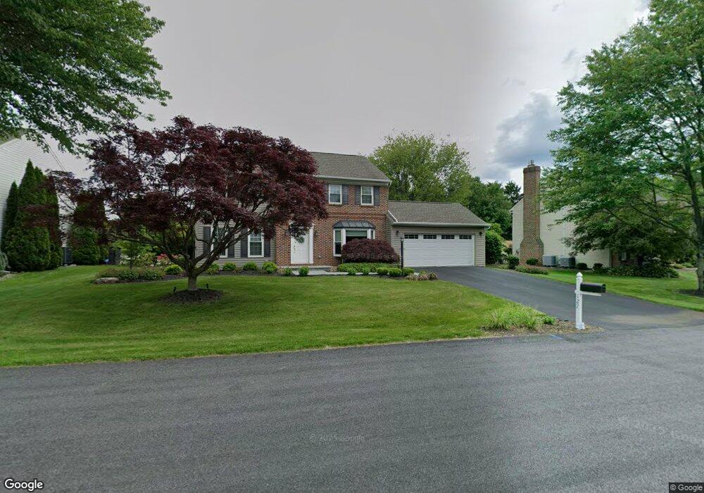
127 Aspen Dr Allentown, PA 18104
Upper Macungie Township NeighborhoodEstimated Value: $533,845 - $695,000
4
Beds
3
Baths
2,372
Sq Ft
$246/Sq Ft
Est. Value
About This Home
This home is located at 127 Aspen Dr, Allentown, PA 18104 and is currently estimated at $584,211, approximately $246 per square foot. 127 Aspen Dr is a home located in Lehigh County with nearby schools including Highland Elementary School, Tussing Elementary School, and Cetronia Elementary School.
Ownership History
Date
Name
Owned For
Owner Type
Purchase Details
Closed on
Jul 14, 1995
Sold by
D'Ambrosio David T and D'Ambrosio Ann E
Bought by
Sullivan Sullivan W and Sullivan Tammra L
Current Estimated Value
Purchase Details
Closed on
Jun 4, 1993
Sold by
Black Kenneth C and Black Donna A
Bought by
D'Ambrosio David T and D'Ambrosio Ann E
Purchase Details
Closed on
May 28, 1987
Sold by
Mirth Thomas A and Mirth Deborah L
Bought by
Black Kenneth C and Black Donna A
Purchase Details
Closed on
May 22, 1986
Bought by
Mirth Thomas A and Mirth Deborah L
Create a Home Valuation Report for This Property
The Home Valuation Report is an in-depth analysis detailing your home's value as well as a comparison with similar homes in the area
Home Values in the Area
Average Home Value in this Area
Purchase History
| Date | Buyer | Sale Price | Title Company |
|---|---|---|---|
| Sullivan Sullivan W | $186,000 | -- | |
| D'Ambrosio David T | $185,000 | -- | |
| Black Kenneth C | $143,600 | -- | |
| Mirth Thomas A | $480,000 | -- |
Source: Public Records
Tax History Compared to Growth
Tax History
| Year | Tax Paid | Tax Assessment Tax Assessment Total Assessment is a certain percentage of the fair market value that is determined by local assessors to be the total taxable value of land and additions on the property. | Land | Improvement |
|---|---|---|---|---|
| 2025 | $5,583 | $258,000 | $46,600 | $211,400 |
| 2024 | $5,372 | $258,000 | $46,600 | $211,400 |
| 2023 | $5,243 | $258,000 | $46,600 | $211,400 |
| 2022 | $5,219 | $258,000 | $211,400 | $46,600 |
| 2021 | $5,219 | $258,000 | $46,600 | $211,400 |
| 2020 | $5,219 | $258,000 | $46,600 | $211,400 |
| 2019 | $5,108 | $258,000 | $46,600 | $211,400 |
| 2018 | $5,008 | $258,000 | $46,600 | $211,400 |
| 2017 | $4,936 | $258,000 | $46,600 | $211,400 |
| 2016 | -- | $258,000 | $46,600 | $211,400 |
| 2015 | -- | $258,000 | $46,600 | $211,400 |
| 2014 | -- | $258,000 | $46,600 | $211,400 |
Source: Public Records
Map
Nearby Homes
- 5926 Holiday Dr
- 5821 Daniel St
- 6126 Palomino Dr
- 280 Susquehanna Trail
- 2021 Hickory Ln
- 5137 Schantz Rd Unit The Jackson
- The Kennedy Plan at The Reserve at Surrey Court
- The Jefferson - Front Entry Plan at The Reserve at Surrey Court
- 5137 Schantz Rd Unit The Kennedy
- 5137 Schantz Rd Unit The Roosevelt
- The Jackson - Front Entry Plan at The Reserve at Surrey Court
- 5137 Schantz Rd Unit The Madison
- The Monroe Plan at The Reserve at Surrey Court
- 5137 Schantz Rd Unit The Monroe
- The Roosevelt - Front Entry Plan at The Reserve at Surrey Court
- The Madison Plan at The Reserve at Surrey Court
- 5137 Schantz Rd Unit The Jefferson
- 6401 Fir Rd
- 241 Snapdragon Way
- 365 Pennycress Rd