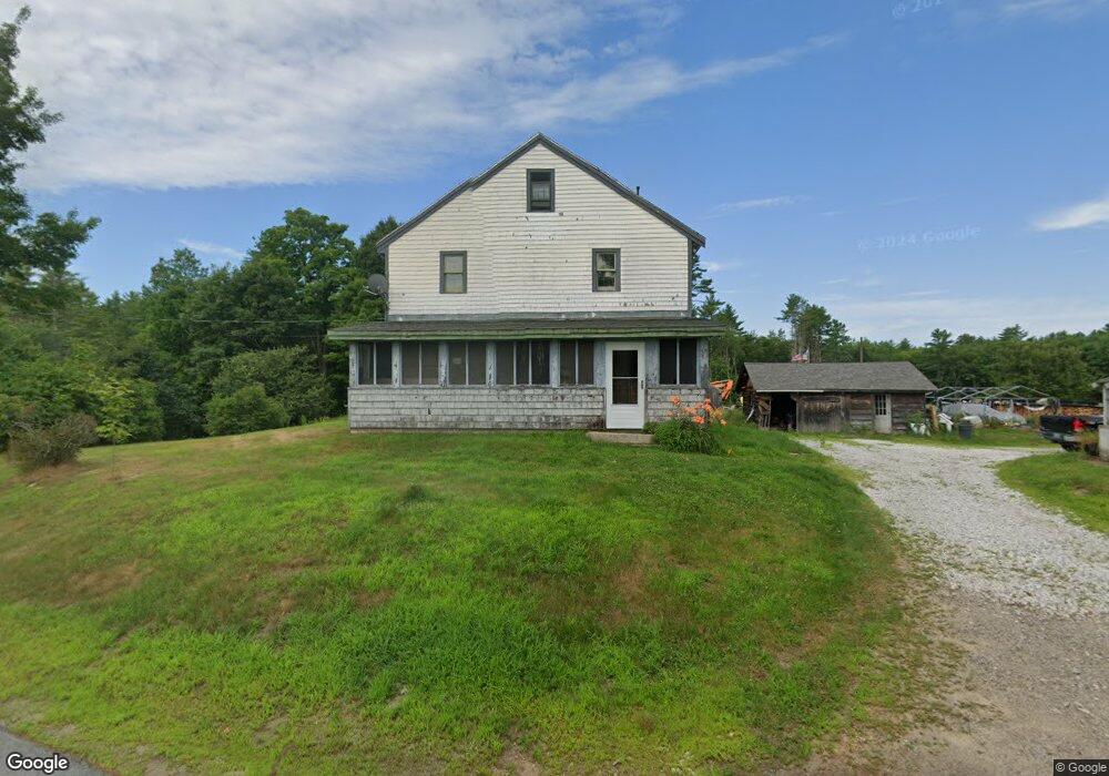
127 Gray Rd Barnstead, NH 03218
Estimated Value: $442,000 - $687,000
4
Beds
2
Baths
2,106
Sq Ft
$251/Sq Ft
Est. Value
About This Home
This home is located at 127 Gray Rd, Barnstead, NH 03218 and is currently estimated at $528,195, approximately $250 per square foot. 127 Gray Rd is a home with nearby schools including Barnstead Elementary School and Prospect Mountain High School.
Ownership History
Date
Name
Owned For
Owner Type
Purchase Details
Closed on
Apr 1, 2009
Sold by
Moody Winship B
Bought by
Shute Kevin E and Caruso Blyth S
Current Estimated Value
Home Financials for this Owner
Home Financials are based on the most recent Mortgage that was taken out on this home.
Original Mortgage
$168,393
Outstanding Balance
$104,487
Interest Rate
4.92%
Mortgage Type
Purchase Money Mortgage
Estimated Equity
$423,708
Purchase Details
Closed on
Feb 2, 2001
Sold by
Lemieux Robert T
Bought by
Barnes John S and Barnes Sheila A
Home Financials for this Owner
Home Financials are based on the most recent Mortgage that was taken out on this home.
Original Mortgage
$140,600
Interest Rate
7.14%
Purchase Details
Closed on
Oct 4, 1996
Sold by
Florand Ernest R and Florand Ann G
Bought by
Lemieux Robert T
Home Financials for this Owner
Home Financials are based on the most recent Mortgage that was taken out on this home.
Original Mortgage
$63,000
Interest Rate
7.9%
Create a Home Valuation Report for This Property
The Home Valuation Report is an in-depth analysis detailing your home's value as well as a comparison with similar homes in the area
Home Values in the Area
Average Home Value in this Area
Purchase History
| Date | Buyer | Sale Price | Title Company |
|---|---|---|---|
| Shute Kevin E | $175,000 | -- | |
| Barnes John S | $148,000 | -- | |
| Lemieux Robert T | $84,000 | -- |
Source: Public Records
Mortgage History
| Date | Status | Borrower | Loan Amount |
|---|---|---|---|
| Open | Lemieux Robert T | $168,393 | |
| Closed | Lemieux Robert T | $123,500 | |
| Previous Owner | Lemieux Robert T | $140,600 | |
| Previous Owner | Lemieux Robert T | $63,000 |
Source: Public Records
Tax History
| Year | Tax Paid | Tax Assessment Tax Assessment Total Assessment is a certain percentage of the fair market value that is determined by local assessors to be the total taxable value of land and additions on the property. | Land | Improvement |
|---|---|---|---|---|
| 2025 | $4,736 | $276,126 | $83,426 | $192,700 |
| 2024 | $4,504 | $276,145 | $83,445 | $192,700 |
| 2023 | $3,963 | $276,196 | $83,496 | $192,700 |
| 2022 | $4,148 | $192,027 | $48,427 | $143,600 |
| 2021 | $4,222 | $192,261 | $48,661 | $143,600 |
| 2020 | $0 | $192,459 | $48,859 | $143,600 |
| 2019 | $4,397 | $192,603 | $49,003 | $143,600 |
| 2018 | $0 | $192,294 | $48,694 | $143,600 |
| 2017 | $0 | $108,794 | $37,194 | $71,600 |
| 2016 | $0 | $108,854 | $37,254 | $71,600 |
| 2015 | $2,956 | $108,877 | $37,277 | $71,600 |
| 2014 | $3,322 | $138,643 | $42,943 | $95,700 |
| 2013 | $3,234 | $137,620 | $43,020 | $94,600 |
Source: Public Records
Map
Nearby Homes
- 4 Sandy Point Rd
- M2-l29-9 Province Rd
- L33 Province Rd
- L68-1 Vail Rd
- L68-2 Vail Rd
- 56 Beaver Pond Dr
- 22 Pinepark Dr
- 33 W Meadow Rd
- 25 Vail Rd
- 38 Chapelle Rd
- 88 Winant Rd
- Map R29 Lot 1 Catamount Rd
- 97 Fairview Dr
- 47 Carroll St
- Lot 72 Holmes Rd
- 79 High St
- 18 Catamount Rd
- 110 Main St
- 4 Depot St
- Lot 33 Ridge Rd
Your Personal Tour Guide
Ask me questions while you tour the home.