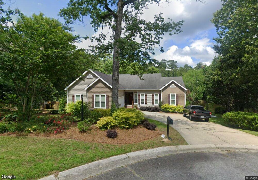
127 Huntington Place Macon, GA 31210
Estimated Value: $308,000 - $364,000
3
Beds
2
Baths
2,414
Sq Ft
$139/Sq Ft
Est. Value
About This Home
This home is located at 127 Huntington Place, Macon, GA 31210 and is currently estimated at $334,350, approximately $138 per square foot. 127 Huntington Place is a home located in Bibb County with nearby schools including Lane Elementary School, Howard Middle School, and Howard High School.
Ownership History
Date
Name
Owned For
Owner Type
Purchase Details
Closed on
Feb 6, 2007
Sold by
Brennan William R and Brennan Jean M
Bought by
Edelkind Gilda P
Current Estimated Value
Home Financials for this Owner
Home Financials are based on the most recent Mortgage that was taken out on this home.
Original Mortgage
$180,000
Outstanding Balance
$106,781
Interest Rate
6.17%
Mortgage Type
Purchase Money Mortgage
Estimated Equity
$227,569
Create a Home Valuation Report for This Property
The Home Valuation Report is an in-depth analysis detailing your home's value as well as a comparison with similar homes in the area
Home Values in the Area
Average Home Value in this Area
Purchase History
| Date | Buyer | Sale Price | Title Company |
|---|---|---|---|
| Edelkind Gilda P | $225,000 | None Available |
Source: Public Records
Mortgage History
| Date | Status | Borrower | Loan Amount |
|---|---|---|---|
| Open | Edelkind Gilda P | $180,000 |
Source: Public Records
Tax History Compared to Growth
Tax History
| Year | Tax Paid | Tax Assessment Tax Assessment Total Assessment is a certain percentage of the fair market value that is determined by local assessors to be the total taxable value of land and additions on the property. | Land | Improvement |
|---|---|---|---|---|
| 2025 | $2,607 | $113,079 | $25,337 | $87,742 |
| 2024 | $2,610 | $109,774 | $22,032 | $87,742 |
| 2023 | $2,874 | $104,034 | $22,032 | $82,002 |
| 2022 | $3,862 | $118,562 | $18,662 | $99,900 |
| 2021 | $2,997 | $85,875 | $15,551 | $70,324 |
| 2020 | $2,884 | $81,274 | $15,551 | $65,723 |
| 2019 | $2,907 | $81,274 | $15,551 | $65,723 |
| 2018 | $4,633 | $81,274 | $15,551 | $65,723 |
| 2017 | $2,783 | $81,274 | $15,551 | $65,723 |
| 2016 | $2,570 | $81,274 | $15,551 | $65,723 |
| 2015 | $3,638 | $81,274 | $15,551 | $65,723 |
| 2014 | $1,215 | $81,274 | $15,551 | $65,723 |
Source: Public Records
Map
Nearby Homes
- 668 Monticlair Dr
- 602 Commanche Dr
- 556 Commanche Place
- 106 Brandon Way
- 750 Stonington Place
- 673 Commanche Dr
- 1224 Timberlane Dr
- 4713 Lattimore Dr
- 4811 Guerry Dr
- 825 Forest Lake Dr S
- 4620 S Stratford Oaks Dr
- 731 Lokchapee Dr
- 1270 Lake Valley Rd
- 753 Lokchapee Dr
- 636 Lokchapee Ridge
- 859 Forest Lake Dr S
- 627 Lokchapee Ridge
- 1344 Lake Valley Rd
- 203 Oberon Place
- 125 Huntington Place
- 129 Huntington Place
- 126 Huntington Place
- 123 Huntington Place
- 124 Huntington Place
- 122 Huntington Place
- 121 Huntington Place
- 692 Sioux Dr
- 696 Sioux Dr
- 120 Huntington Place
- 678 Sioux Dr
- 652 Monticlair Dr
- 119 Huntington Place Unit 18
- 584 Commanche Dr
- 570 Commanche Dr
- 662 Sioux Dr
- 558 Commanche Dr
- 656 Monticlair Dr
- 640 Sioux Dr
- 672 Monticlair Dr