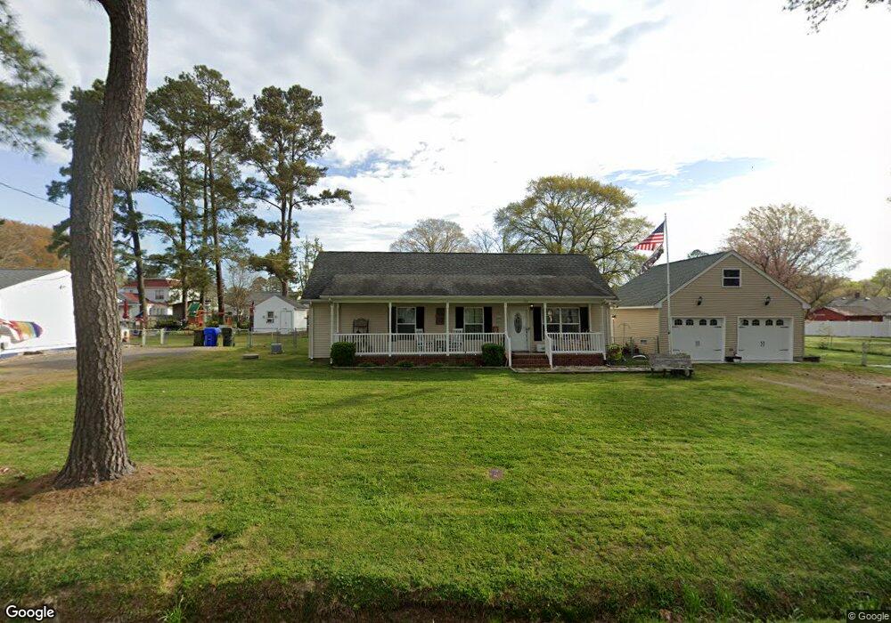
127 Lane St Suffolk, VA 23438
Estimated Value: $366,577 - $376,000
3
Beds
2
Baths
1,965
Sq Ft
$189/Sq Ft
Est. Value
About This Home
This home is located at 127 Lane St, Suffolk, VA 23438 and is currently estimated at $370,894, approximately $188 per square foot. 127 Lane St is a home located in Suffolk City with nearby schools including Southwestern Elementary School, John F. Kennedy Middle School, and Lakeland High School.
Ownership History
Date
Name
Owned For
Owner Type
Purchase Details
Closed on
Mar 30, 2021
Sold by
Mcdermott Deborah S
Bought by
Paulosky William F
Current Estimated Value
Home Financials for this Owner
Home Financials are based on the most recent Mortgage that was taken out on this home.
Original Mortgage
$262,305
Outstanding Balance
$192,144
Interest Rate
2.8%
Mortgage Type
VA
Estimated Equity
$178,750
Purchase Details
Closed on
Nov 2, 2018
Sold by
Mcdermott Paul and Mcdermott Deborah
Bought by
Mcdermott Deborah S
Create a Home Valuation Report for This Property
The Home Valuation Report is an in-depth analysis detailing your home's value as well as a comparison with similar homes in the area
Purchase History
| Date | Buyer | Sale Price | Title Company |
|---|---|---|---|
| Paulosky William F | $290,000 | Attorney | |
| Mcdermott Deborah S | -- | None Available |
Source: Public Records
Mortgage History
| Date | Status | Borrower | Loan Amount |
|---|---|---|---|
| Open | Paulosky William F | $262,305 |
Source: Public Records
Tax History
| Year | Tax Paid | Tax Assessment Tax Assessment Total Assessment is a certain percentage of the fair market value that is determined by local assessors to be the total taxable value of land and additions on the property. | Land | Improvement |
|---|---|---|---|---|
| 2025 | $4,166 | $347,300 | $51,400 | $295,900 |
| 2024 | $4,166 | $332,300 | $51,400 | $280,900 |
| 2023 | $3,949 | $321,800 | $51,400 | $270,400 |
| 2022 | $3,141 | $288,200 | $51,400 | $236,800 |
| 2021 | $2,485 | $223,900 | $42,900 | $181,000 |
| 2020 | $2,083 | $187,700 | $39,000 | $148,700 |
| 2019 | $1,880 | $169,400 | $39,000 | $130,400 |
| 2018 | $1,903 | $164,800 | $39,000 | $125,800 |
| 2017 | $1,707 | $159,500 | $33,700 | $125,800 |
| 2016 | $1,707 | $159,500 | $33,700 | $125,800 |
| 2015 | $993 | $159,500 | $33,700 | $125,800 |
| 2014 | $993 | $159,500 | $33,700 | $125,800 |
Source: Public Records
Map
Nearby Homes
- 6200 Whaleyville Blvd
- 6322 Whaleyville Blvd
- 6140 Whaleyville Blvd
- 238 Mineral Spring Rd
- 115 Robertson St
- 118 Sumner St
- 5055 Mineral Spring Rd
- 5059 Mineral Spring Rd
- 4AC Little Fork Rd
- 377 Little Fork Rd
- 5748 Whaleyville Blvd
- .110ac Mineral Spring Rd
- 2AC+/- Little Fork Rd
- 2.87AC Little Fork Rd
- 3.36AC Little Fork Rd
- 1691 Freeman Mill Rd
- 4809 Mineral Spring Rd
- 865 Greenway Rd
- 1120 Rountree Crescent
- 2468 Freeman Mill Rd
Your Personal Tour Guide
Ask me questions while you tour the home.