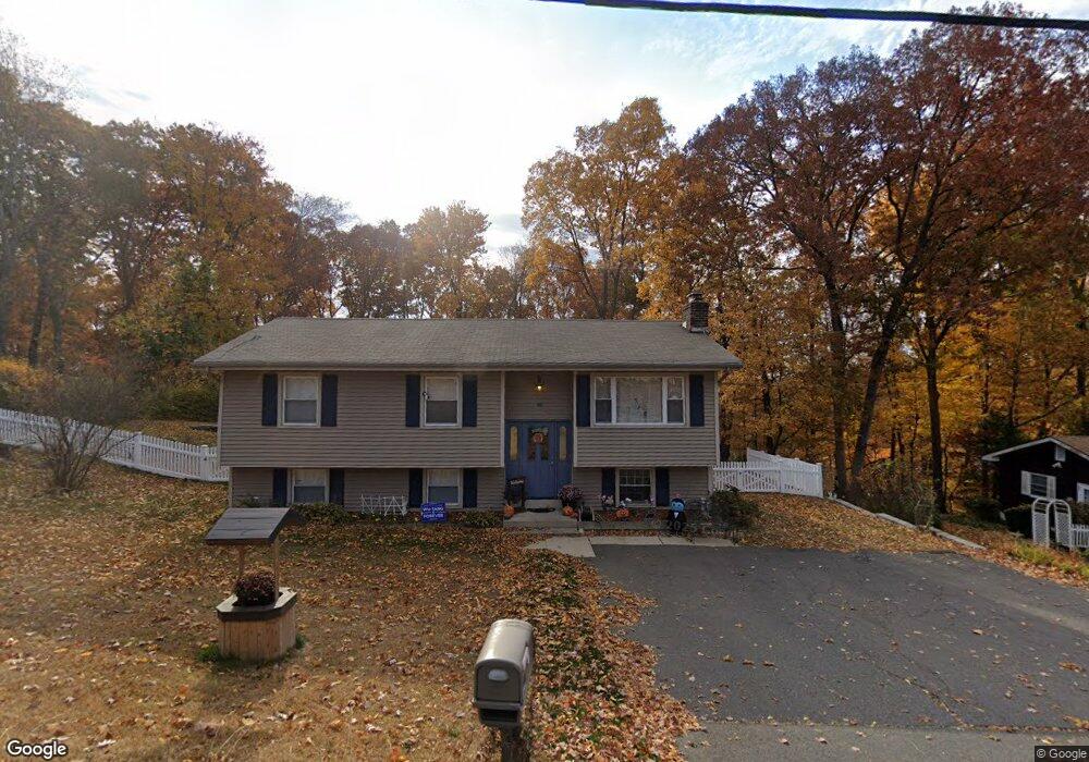
127 Lyman Rd Wolcott, CT 06716
Estimated Value: $366,000 - $396,000
3
Beds
2
Baths
1,474
Sq Ft
$258/Sq Ft
Est. Value
About This Home
This home is located at 127 Lyman Rd, Wolcott, CT 06716 and is currently estimated at $380,503, approximately $258 per square foot. 127 Lyman Rd is a home located in New Haven County with nearby schools including Tyrrell Middle School and Wolcott High School.
Ownership History
Date
Name
Owned For
Owner Type
Purchase Details
Closed on
Jun 12, 2017
Sold by
Ricciardi Carmine and Ricciardi Katy A
Bought by
Ricciardi Alexander
Current Estimated Value
Home Financials for this Owner
Home Financials are based on the most recent Mortgage that was taken out on this home.
Original Mortgage
$131,000
Outstanding Balance
$108,995
Interest Rate
4.03%
Mortgage Type
Purchase Money Mortgage
Estimated Equity
$271,508
Purchase Details
Closed on
Nov 28, 1995
Sold by
Monahan Leona
Bought by
Ricciardi Carmine and Ricciardi Katy A
Home Financials for this Owner
Home Financials are based on the most recent Mortgage that was taken out on this home.
Original Mortgage
$65,900
Interest Rate
7.47%
Mortgage Type
Unknown
Create a Home Valuation Report for This Property
The Home Valuation Report is an in-depth analysis detailing your home's value as well as a comparison with similar homes in the area
Home Values in the Area
Average Home Value in this Area
Purchase History
| Date | Buyer | Sale Price | Title Company |
|---|---|---|---|
| Ricciardi Alexander | $200,000 | -- | |
| Ricciardi Carmine | $87,900 | -- |
Source: Public Records
Mortgage History
| Date | Status | Borrower | Loan Amount |
|---|---|---|---|
| Open | Ricciardi Alexander | $131,000 | |
| Previous Owner | Ricciardi Carmine | $64,000 | |
| Previous Owner | Ricciardi Carmine | $24,169 | |
| Previous Owner | Ricciardi Carmine | $65,900 |
Source: Public Records
Tax History
| Year | Tax Paid | Tax Assessment Tax Assessment Total Assessment is a certain percentage of the fair market value that is determined by local assessors to be the total taxable value of land and additions on the property. | Land | Improvement |
|---|---|---|---|---|
| 2025 | $6,023 | $167,630 | $38,700 | $128,930 |
| 2024 | $5,544 | $167,630 | $38,700 | $128,930 |
| 2023 | $5,342 | $167,630 | $38,700 | $128,930 |
| 2022 | $5,163 | $167,630 | $38,700 | $128,930 |
| 2021 | $4,824 | $145,570 | $36,710 | $108,860 |
| 2020 | $4,824 | $145,570 | $36,710 | $108,860 |
| 2019 | $4,824 | $145,570 | $36,710 | $108,860 |
| 2018 | $4,687 | $145,570 | $36,710 | $108,860 |
| 2017 | $4,552 | $145,570 | $36,710 | $108,860 |
| 2016 | $4,414 | $152,680 | $37,370 | $115,310 |
| 2015 | $4,287 | $152,680 | $37,370 | $115,310 |
| 2014 | $4,148 | $152,680 | $37,370 | $115,310 |
Source: Public Records
Map
Nearby Homes
- 128 Lyman Rd Unit 24
- 63 Lyman Rd
- 9 Pembroke Hill Rd
- 22 Pembroke Hill Rd
- 19 Klan Dr
- 8 Oakengate Rd
- 17 Forestview Dr
- 16 Oakengate Rd
- 25 Hillside Dr
- 65 Munson Rd
- 69 Munson Rd
- 210 Munson Rd Unit 2-D
- 210 Munson Rd Unit 2-B
- 210 Munson Rd Unit 2-F
- 210 Munson Rd Unit 3B
- 210 Munson Rd Unit 2-G
- 210 Munson Rd Unit 2-C
- 18 Manor Ln
- 52 Chestnut Hill Rd
- 866 Wolcott Rd
Your Personal Tour Guide
Ask me questions while you tour the home.